Location
Latitude: |
38-20-15.4000N (38.337611) |
Longitude: |
096-59-17.7000W (-96.98825) |
Elevation: |
1390.0 feet MSL (424 m MSL) |
Magnetic Variation: |
2.8 E (as of April 2024 from WMM2020 model) |
Time Zone: |
UTC -6.0 (Standard Time) UTC -5.0 (Daylight Savings Time) |
From City: |
02 N.M. SE of Marion, Kansas |
Found On: |
Kansas City Chart |
FAA Region: |
ACE |
Contacts
Manager: |
Publicly owned: |
| MARK SKILES 208 EAST SANTA FE MARION, KS 66861 620-382-3703 |
CITY OF MARION 208 EAST SANTA FE MARION, KS 66861 620-382-3703 |
Operations
Airport Status: |
Operational |
Facility Use: |
Public |
Type: |
Airport |
Activation Date: |
12/1945 |
Control tower: |
No |
Attendance (Months/Days/Hours): |
Months/Days/Hours Unattended |
Boundary ARTCC: |
ZKC (Kansas City) |
Responsible ARTCC: |
ZKC (Kansas City) |
Segmented Circle Indicator: |
No |
Traffic Pattern Altitude (MSL): |
2390 feet (728 m) |
NOTAMs Facility: |
ICT |
NOTAM-D Service: |
Yes |
Civil/Military Joint Use: |
No |
Based Aircraft
| Single Engine: | 16 |
| Ultralights: | 1 |
Annual Operations (as of 10/24/2022)
| Total Operations: | 9024 | |
| GA Local: | 6000 | 66.5% |
| GA Itinerant: | 3000 | 33.2% |
| Military Aircraft: | 24 | 0.3% |
Communications
| CTAF: | 122.900 |
Fixed Based Operators (FBOs) & Fuel
(Click on a business for detail)
Please help us keep this information up to date. This is a FREE SERVICE just like everything else on Airport Guide! If you see that a business needs to be added, modified, or deleted please fill out our Update Form.
To add, modify, or delete a business click here.
Please help us keep this information up to date. This is a FREE SERVICE just like everything else on Airport Guide! If you see that a business needs to be added, modified, or deleted please fill out our Update Form.
Area Code: 620 |
| Business Name | Frequency | Phone | Fuel Grade |
|---|
Flight Service Stations
| Primary | Alternate | |
| FSS on Field: | N | |
| FSS Name (ID): | Wichita(ICT) | |
| Frequency: | ||
| Toll Free Phone: | 1-800-WX-BRIEF |
Instrument Procedures / Charts
Terminal Procedures are only available for airports in several countries with more being added all the time. If you are looking for a specific country's charts, please send an email to support(at)airportguide.com stating the country name. This will be used to prioritize the implementation.
Navigation Aids (Navaids) near 43K
| Dist (NM) | ID | Morse Code | Name | Type | Freq | True Hdg | Mag Hdg |
|---|---|---|---|---|---|---|---|
| 17.8 | CA | _ . _ . . _ | Harvs | NDB | 395 | 229 | 226 |
| 21.2 | EWK | . . _ _ _ . _ | Newton | NDB | 281 | 219 | 216 |
| 22.9 | HRU | . . . . . _ . . . _ | Herington | NDB | 407 | 21 | 18 |
| 32.9 | MPR | _ _ . _ _ . . _ . | Mc Pherson | NDB | 227 | 271 | 268 |
| 37.1 | SL | . . . . _ . . | Flory | NDB | 344 | 303 | 300 |
| 38.4 | FRI | . . _ . . _ . . . | Fort Riley | VOR | 109.40 | 8 | 5 |
| 40.1 | EMP | . _ _ . _ _ . | Emporia | VORTAC | 112.80 | 93 | 90 |
| 42.3 | CVY | _ . _ . . . . _ _ . _ _ | Cavalry | NDB | 314 | 12 | 9 |
| 44.9 | IAB | . . . _ _ . . . | Mc Connell | TACAN | 116.50 | 197 | 194 |
| 45.3 | ICT | . . _ . _ . _ | Wichita | VORTAC | 113.80 | 218 | 215 |
| 46.1 | HU | . . . . . . _ | Saltt | NDB | 404 | 254 | 251 |
| 46.1 | SLN | . . . . _ . . _ . | Salina | VORTAC | 117.10 | 320 | 317 |
| 47.0 | ICT | . . _ . _ . _ | Wichita | VOT | 114.00 | 206 | 203 |
| 49.1 | HUT | . . . . . . _ _ | Hutchinson | VOR-DME | 116.80 | 245 | 242 |
| 50.6 | IC | . . _ . _ . | Piche | NDB | 332 | 206 | 203 |
| 50.7 | MHK | _ _ . . . . _ . _ | Manhattan | VOR-DME | 110.20 | 17 | 14 |
| 58.3 | LYO | . _ . . _ . _ _ _ _ _ | Lyons | NDB | 386 | 270 | 267 |
| 59.7 | UKL | . . _ _ . _ . _ . . | Boyd | NDB | 245 | 91 | 89 |
| 63.1 | CYW | _ . _ . _ . _ _ . _ _ | Clay Center | NDB | 362 | 352 | 349 |
| 63.7 | EGT | . _ _ . _ | Wellington | NDB | 414 | 197 | 194 |
Nearby Airports with Fuel
Notices to Airmen (NOTAMS)
Remarks
| A110-1 | FOR CD CTC KANSAS CITY ARTCC AT 913-254-8508. |
| A14 | MR.MAYFIELD IS CITY MGR. OF MARION KS. |
| A17 | PHONE AVBL 24 HRS. |
| A33-03/21 | RY 03/21 IS SLIGHTLY ROUGH. |
| A42-03 | 03/21 THLDS & EDGES MKD WITH YELLOW PAINTED TIRES. |
| A42-13 | 13/31 THLD & EDGES MKD WITH YELLOW PAINTED TIRES. |
| A42-17 | RWY 17 ALIGNMENT NUMBERS FADED. |
| A42-18 | RY 18/36 THLD DELINEATED WITH YELLOW PAINTED TIRES. |
| A42-35 | RWY 35 ALIGNMENT NUMBERS FADED. |
| A52-03 | THE PROXIMITY OF THE FENCE TO THE RWY ESTABLISHES THE CONTROLLING OBSTRUCTION. THE 35' TO 40' TREES DIRECTLY BEHIND WOULD BE MORE OF A CONCERN FOR APPROACHING AIRCRAFT. |
| A58-17 | +4' FENCE 5' FROM RWY END 30' L & R OF CNTRLEN; LOWERED AT RWY. |
| A58-35 | RWY 35 ROAD ABANDONED & IS GATED FM TRAFFIC. +4 FT FENCE; 70 FT FRM END OF RWY; BOTH SIDES OF RWY. |
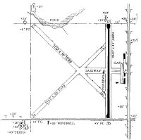
Runways
Runway Summary
| Runways: | 03/21 13/31 17/35 18/36 |
| Longest Runway: | 03/21 is 2745 ft (837 m) long |
| Runways with an Instrument Approach: |
43K Airport Runway Details
| Runway 03/21 | 2745 ft x 95 ft (837 m x 29 m) | |
| Surface: | Turf - Good condition - No special surface treatment | |
Runway 03 |
Runway 21 |
|
Glide Path Angle: |
0.0 degrees | 0.0 degrees |
Traffic Pattern: |
Left | Left |
Object at End: |
FENCE | PLINE |
Object Height: |
5 | 30 |
Distance from End: |
0 | 680 |
Object Centerline Offset: |
0 ft. left and right of centerline | 164 ft. left of centerline |
| Runway 13/31 | 2722 ft x 50 ft (830 m x 15 m) | |
| Surface: | Turf - Good condition - No special surface treatment | |
Runway 13 |
Runway 31 |
|
Glide Path Angle: |
0.0 degrees | 0.0 degrees |
Traffic Pattern: |
Left | Left |
Object at End: |
TREE | |
Object Height: |
46 | |
Distance from End: |
22 | |
Object Centerline Offset: |
0 ft. left and right of centerline | 164 ft. left of centerline |
| Runway 17/35 | 2573 ft x 40 ft (784 m x 12 m) | |
| Surface: | Turf - Good condition - No special surface treatment | |
| Runway Edge Lights: | Low Intensity | |
Runway 17 |
Runway 35 |
|
Elevation: |
1382.0 | 1378.0 |
Latitude: |
38-20-27.3327N | 38-20-01.8917N |
Longitude: |
096-59-13.6390W | 096-59-13.6390W |
|
Runway True Alignment: |
180 | 000 |
Glide Path Angle: |
0.0 degrees | 0.0 degrees |
Traffic Pattern: |
Left | Left |
Runway Markings Type: |
Numbers Only | Numbers Only |
Runway Markings Condition: |
Good | Good |
Object Centerline Offset: |
0 ft. left and right of centerline | 164 ft. left of centerline |
| Runway 18/36 | 2310 ft x 67 ft (704 m x 20 m) | |
| Runway Length Source: | STATE as of 10/21/2002 | |
| Surface: | Turf - Good condition - No special surface treatment | |
Runway 18 |
Runway 36 |
|
Elevation: |
1380.0 | 1378.0 |
Latitude: |
38-20-27.5670N | 38-20-04.7789N |
Longitude: |
096-59-21.1355W | 096-59-23.1002W |
|
Runway True Alignment: |
184 | 004 |
Glide Path Angle: |
0.0 degrees | 0.0 degrees |
Object at End: |
ROAD | TREE |
Object Height: |
15 | 24 |
Distance from End: |
227 | 256 |
Object Centerline Offset: |
0 ft. left and right of centerline | 164 ft. left of centerline |
Services
Airframe Repair: |
Major |
Powerplant Repair: |
Major |
Bottled Oxygen: |
None |
Bulk Oxygen: |
None |
Fuel Available: |
100LL, Jet A |
Landing Fees: |
No |
Parking: |
Hangars and tiedowns available |
Other Services: |
Parachute rental |
Maps & Diagrams
43K Sectional
Flight Planning
at skyvector.com
at skyvector.com