Location
Latitude: |
42-06-12.9600N (42.1036) |
Longitude: |
123-40-56.7000W (-123.682417) |
Elevation: |
1394.0 feet MSL (425 m MSL) |
Magnetic Variation: |
14.2 E (as of April 2024 from WMM2020 model) |
Time Zone: |
UTC -8.0 (Standard Time) UTC -7.0 (Daylight Savings Time) |
From City: |
04 N.M. SW of Cave Junction, Oregon |
Found On: |
Klamath Falls Chart |
FAA Region: |
ANM |
Contacts
Manager: |
Publicly owned: |
| STEVEN DOBBS 1441 BROOKSIDE BLVD GRANTS PASS, OR 97526 541-955-4535 |
JOSEPHINE COUNTY AIRPORTS 1441 BROOKSIDE BLVD GRANTS PASS, OR 97526 541-955-4535 |
Operations
Airport Status: |
Operational |
Facility Use: |
Public |
Type: |
Airport |
Activation Date: |
09/1945 |
Control tower: |
No |
Attendance (Months/Days/Hours): |
Months/Days/Hours ALL/M-F/0800-1700 |
Boundary ARTCC: |
ZSE (Seattle) |
Responsible ARTCC: |
ZSE (Seattle) |
Lighting Schedule: |
SEE RMK |
Segmented Circle Indicator: |
Yes |
Traffic Pattern Altitude (MSL): |
2394 feet (730 m) |
NOTAMs Facility: |
MMV |
NOTAM-D Service: |
Yes |
International Airport of Entry: |
No |
Customs Landing Rights: |
No |
Military Landing Rights: |
Yes |
Civil/Military Joint Use: |
No |
Based Aircraft
| Single Engine: | 17 |
| GA Helicopters: | 1 |
| Ultralights: | 1 |
Annual Operations (as of 05/11/2021)
| Total Operations: | 6000 | |
| GA Local: | 3500 | 58.3% |
| GA Itinerant: | 2500 | 41.7% |
Communications
| CTAF: | 122.900 |
Fixed Based Operators (FBOs) & Fuel
(Click on a business for detail)
Please help us keep this information up to date. This is a FREE SERVICE just like everything else on Airport Guide! If you see that a business needs to be added, modified, or deleted please fill out our Update Form.
To add, modify, or delete a business click here.
Please help us keep this information up to date. This is a FREE SERVICE just like everything else on Airport Guide! If you see that a business needs to be added, modified, or deleted please fill out our Update Form.
Area Code: 541 |
| Business Name | Frequency | Phone | Fuel Grade |
|---|---|---|---|
| Illinois Valley Aviation
Update FBO info |
Unicom 122.8 | 592-5220 | 100LL |
Flight Service Stations
| Primary | Alternate | |
| FSS on Field: | N | |
| FSS Name (ID): | Mc Minnville(MMV) | |
| Frequency: | ||
| Toll Free Phone: | 1-800-WX-BRIEF |
Instrument Procedures / Charts
Terminal Procedures are only available for airports in several countries with more being added all the time. If you are looking for a specific country's charts, please send an email to support(at)airportguide.com stating the country name. This will be used to prioritize the implementation.
Navigation Aids (Navaids) near 3S4
| Dist (NM) | ID | Morse Code | Name | Type | Freq | True Hdg | Mag Hdg |
|---|---|---|---|---|---|---|---|
| 31.6 | CEC | _ . _ . . _ . _ . | Crescent City | VORTAC | 109.00 | 232 | 218 |
| 39.3 | MFR | _ _ . . _ . . _ . | Medford | VOT | 117.20 | 66 | 52 |
| 39.7 | MEF | _ _ . . . _ . | Medford | NDB | 356 | 63 | 49 |
| 40.9 | OED | _ _ _ . _ . . | Rogue Valley | VORTAC | 113.60 | 56 | 42 |
| 55.5 | FJS | . . _ . . _ _ _ . . . | Fort Jones | VOR-DME | 116.25 | 134 | 120 |
| 58.2 | MOG | _ _ _ _ _ _ _ . | Montague | NDB | 404 | 112 | 98 |
| 66.3 | RBG | . _ . _ . . . _ _ . | Roseburg | VOR-DME | 108.20 | 12 | 358 |
| 69.4 | RBG | . _ . _ . . . _ _ . | Roseburg | NDB | 400 | 11 | 357 |
| 70.0 | ACV | . _ _ . _ . . . . _ | Arcata | VOR-DME | 115.05 | 195 | 181 |
| 81.6 | OTH | _ _ _ _ . . . . | North Bend | VOR-DME | 112.10 | 344 | 330 |
| 82.2 | OT | _ _ _ _ | Emire | NDB | 378 | 340 | 326 |
| 87.0 | LMT | . _ . . _ _ _ | Klamath Falls | VORTAC | 115.90 | 87 | 73 |
| 89.5 | FOT | . . _ . _ _ _ _ | Fortuna | VORTAC | 114.00 | 196 | 182 |
Nearby Airports with Fuel
Notices to Airmen (NOTAMS)
Remarks
| A110-1 | (E94) USFS WX STN. |
| A110-2 | RY 36 DESIGNATED CALM WIND RY. |
| A110-3 | FREQUENT ULTRA-LIGHT ACTIVITY. |
| A110-5 | RWY HAS BASIC MARKINGS WITH SIDE STRIPES |
| A110-6 | FOR CD CTC SEATTLE ARTCC AT 253-351-3694. |
| A110-7 | 4 FT BRUSH IN PRI SFC AREA. |
| A40-18/36 | MIRL SET 1 FT OFF RWY EDGE |
| A57-18 | RWY 18 14:1 BASED ON DTHR. RWY 18 15 FT ROAD AT 330 FT ON CL 22:1 BASED ON DTHR |
| A81-APT | ACTVT REIL 18 & 36; MIRL RWY 18/36 - CTAF. |
| E100 | AUTOMATED UNICOM. ADZY ALSO AVBL BY CALLING 617-262-3825. |
| E111 | ESTABD PRIOR TO 1959. |
Runways
Runway Summary
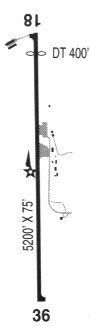
| Runways: | 18/36 |
| Longest Runway: | 18/36 is 4807 ft (1465 m) long |
| Runways with an Instrument Approach: |
3S4 Airport Runway Details
| Runway 18/36 | 4807 ft x 60 ft (1465 m x 18 m) | |
| Runway Length Source: | ADO as of 10/31/2006 | |
| Surface: | Asphalt - Good condition - No special surface treatment | |
| Runway Edge Lights: | Medium Intensity | |
Runway Weight Bearing Capacity (in thousands of pounds) |
||
| Single Wheel Landing Gear: | 20.0 | |
| Dual Wheel Landing Gear: | 30.0 | |
Runway 18 |
Runway 36 |
|
Elevation: |
1353.0 | 1394.0 |
Latitude: |
42-06-35.7130N | 42-05-50.2084N |
Longitude: |
123-40-47.5840W | 123-41-05.8147W |
|
Runway True Alignment: |
197 | 017 |
Glide Path Angle: |
4.0 degrees | 4.0 degrees |
Traffic Pattern: |
Left | Left |
Runway Markings Type: |
Basic | Basic |
Runway Markings Condition: |
Good | Good |
Object at End: |
ROAD | TREES |
Object Height: |
15 | 15 |
Distance from End: |
260 | 325 |
Object Centerline Offset: |
170 ft. left and right of centerline | 140 ft. right of centerline |
Visual Glide Slope Indicators: |
2-Light PAPI On Left Side Of Runway | 2-Light PAPI On Left Side Of Runway |
REIL: |
Yes | Yes |
Threshold Crossing Height: |
57 | 52 |
Threshold Elevation: |
1354.0 | |
Displaced Threshold: |
125 | |
Threshold Latitude: |
42-06-34.5290N | |
Threshold Longitude: |
123-40-48.0580W | |
Declared Distances |
||
Take Off Run Avbl. (TORA): |
4807 | 4682 |
Take Off Distance Avbl. (TODA): |
4807 | 4682 |
Actual Stop Dist. Avbl. (ASDA): |
4807 | 4807 |
Landing Dist. Avbl. (LDA): |
4682 | 4682 |
Services
Bottled Oxygen: |
None |
Bulk Oxygen: |
None |
Fuel Available: |
100LL |
Landing Fees: |
No |
Parking: |
Tiedowns available |
Maps & Diagrams
3S4 Sectional
Flight Planning
at skyvector.com
at skyvector.com