Location
Latitude: |
40-47-44.9000N (40.795806) |
Longitude: |
089-36-48.5000W (-89.613472) |
Elevation: |
793.4 feet MSL (242 m MSL) |
Magnetic Variation: |
2.5 W (as of April 2024 from WMM2020 model) |
Time Zone: |
UTC -6.0 (Standard Time) UTC -5.0 (Daylight Savings Time) |
From City: |
07 N.M. N of Peoria, Illinois |
Found On: |
Chicago Chart |
FAA Region: |
AGL |
Contacts
Manager: |
Publicly owned: |
| GENE OLSON GEN DOWNING PEORIA INTL ARPT, 6100 W. DIRKSEN PKWY PEORIA, IL 61607 309-697-8272 |
METROPOLITAN AIRPORT AUTH OF PEORIA GEN DOWNING PEORIA INTL ARPT, 6100 W. DIRKSEN PKWY PEORIA, IL 61607 309-697-8272 |
Operations
Airport Status: |
Operational |
Facility Use: |
Public |
Type: |
Airport |
Activation Date: |
08/1965 |
Control tower: |
No |
Attendance (Months/Days/Hours): |
Months/Days/Hours ALL/ALL/DAWN-DUSK |
Boundary ARTCC: |
ZAU (Chicago) |
Responsible ARTCC: |
ZKC (Kansas City) |
Lighting Schedule: |
SEE RMK |
Segmented Circle Indicator: |
No |
Traffic Pattern Altitude (MSL): |
1793 feet (547 m) |
NOTAMs Facility: |
IKK |
NOTAM-D Service: |
Yes |
International Airport of Entry: |
No |
Customs Landing Rights: |
No |
Military Landing Rights: |
Yes |
Civil/Military Joint Use: |
No |
Based Aircraft
| Single Engine: | 41 |
| Multi Engine: | 8 |
| GA Helicopters: | 1 |
Annual Operations (as of 08/31/2023)
| Total Operations: | 21000 | |
| Air Taxi: | 300 | 1.4% |
| GA Local: | 12700 | 60.5% |
| GA Itinerant: | 8000 | 38.1% |
Communications
| CTAF: | 122.700 |
| Unicom: | 122.700 |
| Clearance Del.: | 121.6 121.6 121.6 |
| Approach: | SAINT LOUIS |
| Departure: | SAINT LOUIS |
Fixed Based Operators (FBOs) & Fuel
(Click on a business for detail)
Please help us keep this information up to date. This is a FREE SERVICE just like everything else on Airport Guide! If you see that a business needs to be added, modified, or deleted please fill out our Update Form.
To add, modify, or delete a business click here.
Please help us keep this information up to date. This is a FREE SERVICE just like everything else on Airport Guide! If you see that a business needs to be added, modified, or deleted please fill out our Update Form.
Area Code: 309 |
| Business Name | Frequency | Phone | Fuel Grade |
|---|---|---|---|
| North Point Aviation, Inc.
Update FBO info |
Unicom 122.7 | 693-1908, -2372 | 100LL, Jet A |
Flight Service Stations
| Primary | Alternate | |
| FSS on Field: | N | |
| FSS Name (ID): | Kankakee(IKK) | |
| Frequency: | ||
| Toll Free Phone: | 1-800-WX-BRIEF |
Instrument Procedures / Charts
FAA Terminal Procedures valid from 0901Z 03/21/24 to 0901Z 04/18/24.
There are various types of charts available for an airport. They are listed in the Page Type column. Here is a legend for those types:
APD - Airport Diagram
DP - Departure Procedure Charts
HOT - Hot Spots
IAP - Instrument Approach Procedure Charts
MIN - Minimums
STAR - Standard Terminal Arrival Charts
| Page Type | Page Name | Volume | Action Since Last Cycle |
|---|---|---|---|
| IAP | RNAV (GPS) RWY 18 | EC-3 | |
| MIN | TAKEOFF MINIMUMS | EC-3 |
Terminal Procedures are only available for airports in several countries with more being added all the time. If you are looking for a specific country's charts, please send an email to support(at)airportguide.com stating the country name. This will be used to prioritize the implementation.
Navigation Aids (Navaids) near 3MY
| Dist (NM) | ID | Morse Code | Name | Type | Freq | True Hdg | Mag Hdg |
|---|---|---|---|---|---|---|---|
| 10.7 | PIA | . _ _ . . . . _ | Peoria | VORTAC | 115.20 | 229 | 231 |
| 11.4 | PI | . _ _ . . . | Tungg | NDB | 356 | 175 | 178 |
| 21.9 | BDF | _ . . . _ . . . . _ . | Bradford | VORTAC | 114.70 | 3 | 6 |
| 25.2 | CTK | _ . _ . _ _ . _ | Canton | NDB | 236 | 236 | 238 |
| 36.4 | BMI | _ . . . _ _ . . | Bloomington | DME | 108.2 | 121 | 124 |
| 36.5 | LH | . _ . . . . . . | Egrow | NDB | 334 | 112 | 115 |
| 38.2 | GBG | _ _ . _ . . . _ _ . | Galesburg | DME | 109.8 | 283 | 285 |
| 40.0 | PNT | . _ _ . _ . _ | Pontiac | VOR-DME | 109.60 | 87 | 90 |
| 40.2 | AAA | . _ . _ . _ | Abraham | NDB | 329 | 161 | 164 |
| 46.2 | JZY | . _ _ _ _ _ . . _ . _ _ | Macomb | NDB | 251 | 249 | 251 |
| 48.3 | OIX | _ _ _ . . _ . . _ | Ottawa | NDB | 266 | 45 | 48 |
| 53.0 | LQ | . _ . . _ _ . _ | Licol | NDB | 375 | 179 | 182 |
| 55.5 | BOZ | _ . . . _ _ _ _ _ . . | Whiteside | NDB | 254 | 352 | 355 |
| 56.1 | MZV | _ _ _ _ . . . . . _ | Moline | VOR-DME | 114.40 | 304 | 306 |
| 57.4 | SPI | . . . . _ _ . . . | Spinner | VORTAC | 112.70 | 182 | 184 |
| 59.8 | BRL | _ . . . . _ . . _ . . | Burlington | VOR-DME | 111.40 | 266 | 268 |
| 60.1 | CJ | _ . _ . . _ _ _ | Calde | NDB | 240 | 179 | 182 |
| 61.7 | SP | . . . . _ _ . | Huskk | NDB | 382 | 186 | 188 |
| 65.7 | DVN | _ . . . . . _ _ . | Davenport Municipal | VOT | 111.80 | 318 | 320 |
| 67.2 | RBS | . _ . _ . . . . . . | Roberts | VOR-DME | 116.80 | 100 | 103 |
Nearby Airports with Fuel
Notices to Airmen (NOTAMS)
Remarks
| A15 | EMAIL ADDRESS: GOLSON@FLYPIA.COM (ALL LOWER CASE) |
| A16 | EXT 100 OR 103 CELL PHONE: 309-303-0998 |
| A70-FUEL-10 | 0LL 24 HOUR 100LL AND JET-A AVAILABLE WITH CREDIT CARD |
| A81-APT | ACTVT REIL & VASI RY 36.- CTAF, MIRL RWY 18/36 OPERATES SS-SR. |
Runways
Runway Summary
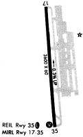
| Runways: | 18/36 |
| Longest Runway: | 18/36 is 4001 ft (1220 m) long |
| Runways with an Instrument Approach: |
3MY Airport Runway Details
| Runway 18/36 | 4001 ft x 60 ft (1220 m x 18 m) | |
| Runway Length Source: | 3RD PARTY SURVEY as of 01/30/2013 | |
| Surface: | Asphalt - Good condition - No special surface treatment | |
| Runway Edge Lights: | Medium Intensity | |
Runway Weight Bearing Capacity (in thousands of pounds) |
||
| Single Wheel Landing Gear: | 20.0 | |
Runway 18 |
Runway 36 |
|
Elevation: |
793.4 | 773.6 |
Latitude: |
40-48-04.6315N | 40-47-25.2524N |
Longitude: |
089-36-50.7574W | 089-36-46.2185W |
|
Runway True Alignment: |
175 | 355 |
Glide Path Angle: |
0.0 degrees | 3.5 degrees |
Traffic Pattern: |
Left | Left |
Runway Markings Type: |
Nonprecision Instrument | Basic |
Runway Markings Condition: |
Good | Good |
Visual Glide Slope Indicators: |
4-Box VASI On Left Side Of Runway | |
REIL: |
No | Yes |
Touchdown Lights: |
No | No |
Centerline Lights: |
No | No |
Threshold Crossing Height: |
32 |
Services
Airframe Repair: |
Major |
Powerplant Repair: |
Major |
Fuel Available: |
100LL |
Landing Fees: |
No |
Parking: |
Hangars and tiedowns available |
Maps & Diagrams
3MY Sectional
Flight Planning
at skyvector.com
at skyvector.com