Location
Latitude: |
40-54-21.6000N (40.906) |
Longitude: |
081-00-00.1000W (-81.000028) |
Elevation: |
1187.5 feet MSL (362 m MSL) |
Magnetic Variation: |
8.7 W (as of April 2024 from WMM2020 model) |
Time Zone: |
UTC -5.0 (Standard Time) UTC -4.0 (Daylight Savings Time) |
From City: |
01 N.M. SE of Sebring, Ohio |
Found On: |
Detroit Chart |
FAA Region: |
AGL |
Contacts
Manager: |
Privately owned: |
| WAYNE HARTER JR 18330 STATE ROUTE 62 BELOIT, OH 44609-9520 330-428-1269 |
3G6 LLC 18330 STATE ROUTE 62 BELOIT, OH 44609-9520 330-938-1216 |
Operations
Airport Status: |
Operational |
Facility Use: |
Public |
Type: |
Airport |
Activation Date: |
07/1969 |
Control tower: |
No |
Attendance (Months/Days/Hours): |
Months/Days/Hours Unattended |
Boundary ARTCC: |
ZOB (Cleveland) |
Responsible ARTCC: |
ZOB (Cleveland) |
Lighting Schedule: |
SEE RMK |
Segmented Circle Indicator: |
No |
Traffic Pattern Altitude (MSL): |
2188 feet (667 m) |
NOTAMs Facility: |
CLE |
NOTAM-D Service: |
Yes |
Based Aircraft
| Single Engine: | 17 |
| Ultralights: | 1 |
Annual Operations (as of 06/21/2023)
| Total Operations: | 1026 | |
| GA Local: | 1000 | 97.5% |
| GA Itinerant: | 26 | 2.5% |
Communications
| CTAF: | 122.900 |
| Approach: | CLEVELAND 125.5 125.5 CLEVELAND ARTCC |
| Departure: | CLEVELAND 125.5 125.5 CLEVELAND ARTCC |
- APCH/DEP SVC PRVDD BY CLEVELAND APCH (CLE) 0600-0100. APCH/DEP SVC PRVDD BY CLEVELAND ARTCC (ZOB) ON FREQS 120.6/379.275 (MOUNT HOPE RCAG) 0100-0600.
Fixed Based Operators (FBOs) & Fuel
(Click on a business for detail)
Please help us keep this information up to date. This is a FREE SERVICE just like everything else on Airport Guide! If you see that a business needs to be added, modified, or deleted please fill out our Update Form.
To add, modify, or delete a business click here.
Please help us keep this information up to date. This is a FREE SERVICE just like everything else on Airport Guide! If you see that a business needs to be added, modified, or deleted please fill out our Update Form.
Area Code: 330 |
| Business Name | Frequency | Phone | Fuel Grade |
|---|---|---|---|
| TopFun Skydiving
Update FBO info |
800-300-5098 | ||
| Tri-City Aviation, Inc.
Update FBO info |
938-1216 | 80, 100LL |
Flight Service Stations
| Primary | Alternate | |
| FSS on Field: | N | |
| FSS Name (ID): | Cleveland(CLE) | |
| Frequency: | ||
| Toll Free Phone: | 1-800-WX-BRIEF |
Instrument Procedures / Charts
FAA Terminal Procedures valid from 0901Z 03/21/24 to 0901Z 04/18/24.
There are various types of charts available for an airport. They are listed in the Page Type column. Here is a legend for those types:
APD - Airport Diagram
DP - Departure Procedure Charts
HOT - Hot Spots
IAP - Instrument Approach Procedure Charts
MIN - Minimums
STAR - Standard Terminal Arrival Charts
| Page Type | Page Name | Volume | Action Since Last Cycle |
|---|---|---|---|
| IAP | RNAV (GPS) RWY 18 | EC-2 | |
| IAP | VOR RWY 18 | EC-2 | |
| MIN | TAKEOFF MINIMUMS | EC-2 |
Terminal Procedures are only available for airports in several countries with more being added all the time. If you are looking for a specific country's charts, please send an email to support(at)airportguide.com stating the country name. This will be used to prioritize the implementation.
Navigation Aids (Navaids) near 3G6
| Dist (NM) | ID | Morse Code | Name | Type | Freq | True Hdg | Mag Hdg |
|---|---|---|---|---|---|---|---|
| 15.2 | ACO | . _ _ . _ . _ _ _ | Akron | VOR-DME | 114.40 | 323 | 332 |
| 20.1 | CAK | _ . _ . . _ _ . _ | Akron/Canton Regional | VOT | 110.60 | 271 | 280 |
| 20.1 | AK | . _ _ . _ | Akron | NDB | 362 | 299 | 308 |
| 22.0 | BSV | _ . . . . . . . . . _ | Briggs | VOR-DME | 112.40 | 243 | 252 |
| 25.4 | YN | _ . _ _ _ . | Fetch | NDB | 338 | 45 | 54 |
| 25.9 | HBD | . . . . _ . . . _ . . | Hubbard | NDB | 408 | 54 | 63 |
| 27.4 | UCP | . . _ _ . _ . . _ _ . | Castle | NDB | 272 | 74 | 83 |
| 29.4 | YNG | _ . _ _ _ . _ _ . | Youngstown | VORTAC | 109.00 | 29 | 38 |
| 36.1 | EWC | . . _ _ _ . _ . | Ellwood City | VOR-DME | 115.80 | 97 | 106 |
| 37.4 | CXR | _ . _ . _ . . _ . _ . | Chardon | VOR-DME | 112.70 | 348 | 357 |
| 40.2 | CFX | _ . _ . . . _ . _ . . _ | Cadiz | NDB | 239 | 180 | 189 |
| 43.5 | HLG | . . . . . _ . . _ _ . | Wheeling | VOR-DME | 114.25 | 152 | 161 |
| 44.4 | MMJ | _ _ _ _ . _ _ _ | Montour | DME | 112 | 124 | 133 |
| 45.3 | MLR | _ _ . _ . . . _ . | Millersburg/Dcmsnd | NDB | 382 | 241 | 249 |
| 46.1 | CTW | _ . _ . _ . _ _ | Newcomerstown | DME | 111.8 | 208 | 217 |
| 49.2 | CLE | _ . _ . . _ . . . | Cleveland | VOT | 110.40 | 308 | 316 |
| 49.6 | LQL | . _ . . _ _ . _ . _ . . | Lakeland | NDB | 263 | 339 | 348 |
| 52.5 | JFN | . _ _ _ . . _ . _ . | Jefferson | DME | 115.2 | 12 | 21 |
| 54.0 | AIR | . _ . . . _ . | Bellaire | VOR-DME | 117.10 | 171 | 180 |
| 56.9 | AAU | . _ . _ . . _ | Ashland | NDB | 329 | 273 | 281 |
Nearby Airports with Fuel
Notices to Airmen (NOTAMS)
Remarks
| A110*G | THIS AIRPORT HAS BEEN SURVEYED BY THE NATIONAL GEODETIC SURVEY. |
| A110-1 | FOR CD CTC CLEVELAND APCH AT 216-352-2323, WHEN APCH CLSD CTC CLEVELAND ARTCC AT 440-774-0223/0490. |
| A110-2 | DEER, BIRDS, & WILDLIFE ON & INVOF ARPT. |
| A33-18/36 | EXCESSIVE CRACKING, VEGETATION THRU CRACKS & JOINTS, & UNEVEN ROUGH PAVEMENT. |
| A40-18/36 | NSTD LIRL DUE TO LAYOUT, COLORS, & NON-FRANGIBLE FIXTURES. |
| A42-18 | CNTRLN FADED. |
| A42-18 1 | NSTD BASIC DUE TO NRS LAYOUT & SIZE. |
| A42-36 | CNTRLN FADED. |
| A42-36 1 | NSTD BASIC DUE TO NRS LAYOUT & SIZE. |
| A58-18 | +18 FT TREES, 46 FT DIST, 92 FT R; +5 FT TREES, 119 FT DIST, 34 FT R. |
| A58-36 | +45 FT TREE, 188 FT DIST, 108 FT R. |
| A70-FUEL-10 | 0LL AVBL ON REQ CALL AMGR. |
| A75 | ROPES NOT PRVDD. |
| A81-APT | ACTVT NSTD LIRL RWY 18/36 - CTAF. |
Runways
Runway Summary
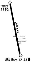
| Runways: | 18/36 |
| Longest Runway: | 18/36 is 2768 ft (844 m) long |
| Runways with an Instrument Approach: |
3G6 Airport Runway Details
| Runway 18/36 | 2768 ft x 45 ft (844 m x 14 m) | |
| Runway Length Source: | NGS as of 11/25/1995 | |
| Surface: | Asphalt - Poor condition - No special surface treatment | |
| Runway Edge Lights: | Non-standard lighting system Intensity | |
Runway 18 |
Runway 36 |
|
Elevation: |
1184.7 | 1177.9 |
Latitude: |
40-54-35.1350N | 40-54-08.0730N |
Longitude: |
081-00-02.6730W | 080-59-57.4570W |
|
Runway True Alignment: |
172 | 352 |
Glide Path Angle: |
0.0 degrees | 0.0 degrees |
Runway Markings Type: |
Nonstandard (other than numbers only) | Nonstandard (other than numbers only) |
Runway Markings Condition: |
Fair | Fair |
Object at End: |
POLE | |
Object Height: |
18 | |
Distance from End: |
315 | |
Object Centerline Offset: |
130 ft. left and right of centerline |
Services
Bottled Oxygen: |
None |
Fuel Available: |
100LL, Jet A, Jet A+ |
Landing Fees: |
No |
Parking: |
Hangars and tiedowns available |
Maps & Diagrams
3G6 Sectional
Flight Planning
at skyvector.com
at skyvector.com