Location
Latitude: |
42-14-59.1400N (42.249761) |
Longitude: |
111-20-29.8580W (-111.341627) |
Elevation: |
5932.9 feet MSL (1808 m MSL) |
Magnetic Variation: |
10.9 E (as of April 2024 from WMM2020 model) |
Time Zone: |
UTC -7.0 (Standard Time) UTC -6.0 (Daylight Savings Time) |
From City: |
03 N.M. E of Paris, Idaho |
Found On: |
Salt Lake City Chart |
FAA Region: |
ANM |
Contacts
Manager: |
Publicly owned: |
| TREVOR KEETCH P O BOX 163 MONTPELIER, ID 83254 208-223-0416 |
BEAR LAKE COUNTY PO BOX 190 PARIS, ID 83261 208-945-2212 |
Operations
Airport Status: |
Operational |
Facility Use: |
Public |
Type: |
Airport |
Activation Date: |
02/1944 |
Control tower: |
No |
Attendance (Months/Days/Hours): |
Months/Days/Hours ALL/ALL/ALL |
Boundary ARTCC: |
ZLC (Salt Lake City) |
Responsible ARTCC: |
ZLC (Salt Lake City) |
Lighting Schedule: |
SEE RMK |
Segmented Circle Indicator: |
Yes |
Traffic Pattern Altitude (MSL): |
6933 feet (2113 m) |
NOTAMs Facility: |
BOI |
NOTAM-D Service: |
Yes |
International Airport of Entry: |
No |
Customs Landing Rights: |
No |
Military Landing Rights: |
No |
Civil/Military Joint Use: |
No |
Based Aircraft
| Single Engine: | 15 |
Annual Operations (as of 06/30/2021)
| Total Operations: | 2600 | |
| GA Local: | 400 | 15.4% |
| GA Itinerant: | 2200 | 84.6% |
Communications
| CTAF: | 122.800 |
| Unicom: | 122.800 |
| AWOS-3: | 118.525 (208 847 0613) |
- APCH/DEP CTL SVC PRVDD BY SALT LAKE ARTCC (ZLC) ON 128.35/239.25 BLACKFOOT RCAG.
Fixed Based Operators (FBOs) & Fuel
(Click on a business for detail)
Please help us keep this information up to date. This is a FREE SERVICE just like everything else on Airport Guide! If you see that a business needs to be added, modified, or deleted please fill out our Update Form.
To add, modify, or delete a business click here.
Please help us keep this information up to date. This is a FREE SERVICE just like everything else on Airport Guide! If you see that a business needs to be added, modified, or deleted please fill out our Update Form.
Area Code: 208 |
| Business Name | Frequency | Phone | Fuel Grade |
|---|---|---|---|
| Bear Lake County Airport
Update FBO info |
Unicom 122.8 | 847-1374 | 100LL |
Flight Service Stations
| Primary | Alternate | |
| FSS on Field: | N | |
| FSS Name (ID): | Boise(BOI) | |
| Frequency: | ||
| Toll Free Phone: | 1-800-WX-BRIEF |
Instrument Procedures / Charts
FAA Terminal Procedures valid from 0901Z 03/21/24 to 0901Z 04/18/24.
There are various types of charts available for an airport. They are listed in the Page Type column. Here is a legend for those types:
APD - Airport Diagram
DP - Departure Procedure Charts
HOT - Hot Spots
IAP - Instrument Approach Procedure Charts
MIN - Minimums
STAR - Standard Terminal Arrival Charts
| Page Type | Page Name | Volume | Action Since Last Cycle |
|---|---|---|---|
| IAP | RNAV (GPS) RWY 10 | NW-1 | |
| IAP | RNAV (GPS) RWY 28 | NW-1 | |
| MIN | ALTERNATE MINIMUMS | NW-1 | |
| MIN | TAKEOFF MINIMUMS | NW-1 | |
| ODP | BEAR LAKE ONE (OBSTACLE) (RNAV) | NW-1 | |
| ODP | FIROS ONE (OBSTACLE) (RNAV) | NW-1 |
Terminal Procedures are only available for airports in several countries with more being added all the time. If you are looking for a specific country's charts, please send an email to support(at)airportguide.com stating the country name. This will be used to prioritize the implementation.
Navigation Aids (Navaids) near 1U7
| Dist (NM) | ID | Morse Code | Name | Type | Freq | True Hdg | Mag Hdg |
|---|---|---|---|---|---|---|---|
| 40.5 | LHO | . _ . . . . . . _ _ _ | Brigham City | VOR-DME | 112.90 | 227 | 216 |
| 49.4 | MLD | _ _ . _ . . _ . . | Malad City | VOR-DME | 117.40 | 266 | 255 |
| 55.0 | BMC | _ . . . _ _ _ . _ . | Brigham City | NDB | 294 | 217 | 206 |
| 58.1 | BPI | _ . . . . _ _ . . . | Big Piney | VOR-DME | 116.50 | 69 | 58 |
| 60.1 | EVW | . . . . _ . _ _ | Evanston | VOR-DME | 109.60 | 167 | 156 |
| 66.5 | FBR | . . _ . _ . . . . _ . | Fort Bridger | VOR-DME | 114.45 | 141 | 130 |
| 67.3 | PI | . _ _ . . . | Tyhee | NDB | 383 | 309 | 298 |
| 68.9 | PIH | . _ _ . . . . . . . | Pocatello | VOR-DME | 112.60 | 303 | 292 |
| 70.2 | OGD | _ _ _ _ _ . _ . . | Ogden | VORTAC | 115.70 | 209 | 198 |
| 73.3 | HIF | . . . . . . . . _ . | Hill | TACAN | 111.20 | 202 | 191 |
| 75.3 | PNA | . _ _ . _ . . _ | Wenz | NDB | 392 | 63 | 52 |
| 79.6 | SWU | . . . . _ _ . . _ | Sweden | NDB | 350 | 333 | 322 |
| 82.5 | IDA | . . _ . . . _ | Idaho Falls | VOR-DME | 113.85 | 337 | 326 |
| 85.6 | ID | . . _ . . | Uconn | NDB | 324 | 341 | 330 |
| 86.5 | JAC | . _ _ _ . _ _ . _ . | Jackson | VOR-DME | 115.40 | 17 | 6 |
| 88.8 | TCH | _ _ . _ . . . . . | Wasatch | VORTAC | 116.80 | 199 | 188 |
| 93.2 | SLC | . . . . _ . . _ . _ . | Salt Lake City | VOT | 111.00 | 197 | 186 |
Nearby Airports with Fuel
Notices to Airmen (NOTAMS)
Remarks
| A110-2 | BIRDS ON & INVOF OF ARPT. |
| A110-3 | REFLECTORS ON ALL TWYS AND APRONS. |
| A110-4 | PARTIAL TWY 25 FT WIDE. |
| A110-7 | NO SNOW REMOVAL RWY 16/34. |
| A110-8 | FOR CD CTC SALT LAKE ARTCC AT 801-320-2568. |
| A110-9 | COLD TEMPERATURE AIRPORT. ALTITUDE CORRECTION REQUIRED AT OR BELOW -23C. |
| A16 | 208-223-0416 CELL, AVBL 24 HRS. |
| A30-16/34 | NO SNOW REMOVAL RWY 16/34. |
| A42-16 | RUNWAY 16/34 HAS RUNWAY SIDE STRIPE MARKING |
| A43-10 | PAPI UNSUBL BYD 8 NM FM THR DUE TO MOUNTAINOUS TRRN. |
| A70-FUEL-10 | 0LL 100 LL FUEL AVBL 24 HRS WITH CREDIT CARD SELF SVC. |
| A81-APT | ACTVT REIL RWY 10 & 28; MIRL RWY 10/28 - CTAF. |
| E111 | ESTABD PRIOR TO 15 MAY 1959. |
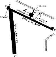
Runways
Runway Summary
| Runways: | 10/28 16/34 |
| Longest Runway: | 10/28 is 5728 ft (1746 m) long |
| Runways with an Instrument Approach: |
1U7 Airport Runway Details
| Runway 10/28 | 5728 ft x 75 ft (1746 m x 23 m) | |
| Runway Length Source: | 3RD PARTY SURVEY as of 06/02/2020 | |
| Surface: | Asphalt - Excellent condition - No special surface treatment | |
| Runway Edge Lights: | Medium Intensity | |
Runway Weight Bearing Capacity (in thousands of pounds) |
||
| Single Wheel Landing Gear: | 14.0 | |
| Dual Wheel Landing Gear: | 28.0 | |
| Dual Tandem Wheel Landing Gear: | 60.0 | |
Runway 10 |
Runway 28 |
|
Elevation: |
5930.2 | 5932.9 |
Latitude: |
42-15-17.0808N | 42-14-53.0840N |
Longitude: |
111-20-51.8817W | 111-19-42.9312W |
|
Runway True Alignment: |
115 | 295 |
Glide Path Angle: |
3.5 degrees | 3.5 degrees |
Traffic Pattern: |
Left | Left |
Runway Markings Type: |
Nonprecision Instrument | Nonprecision Instrument |
Runway Markings Condition: |
Good | Good |
Object at End: |
PLINE | ROAD |
Object Height: |
60 | 12 |
Distance from End: |
2500 | 500 |
Object Centerline Offset: |
0 ft. left and right of centerline | 0 ft. left and right of centerline |
Visual Glide Slope Indicators: |
2-Light PAPI On Left Side Of Runway | 2-Light PAPI On Left Side Of Runway |
REIL: |
Yes | Yes |
Threshold Crossing Height: |
45 | 51 |
| Runway 16/34 | 4590 ft x 60 ft (1399 m x 18 m) | |
| Runway Length Source: | 3RD PARTY SURVEY as of 06/02/2020 | |
| Surface: | Asphalt - Excellent condition - No special surface treatment | |
Runway Weight Bearing Capacity (in thousands of pounds) |
||
| Single Wheel Landing Gear: | 50.0 | |
| Dual Wheel Landing Gear: | 64.0 | |
| Dual Tandem Wheel Landing Gear: | 102.0 | |
Runway 16 |
Runway 34 |
|
Elevation: |
5930.0 | 5929.6 |
Latitude: |
42-15-14.3054N | 42-14-29.1403N |
Longitude: |
111-20-48.0004W | 111-20-42.7856W |
|
Runway True Alignment: |
175 | 355 |
Glide Path Angle: |
0.0 degrees | 0.0 degrees |
Traffic Pattern: |
Left | Left |
Runway Markings Type: |
Basic | Basic |
Runway Markings Condition: |
Good | Good |
Object at End: |
ROAD | |
Object Height: |
19 | |
Distance from End: |
1000 | |
Object Centerline Offset: |
0 ft. left and right of centerline | 0 ft. left and right of centerline |
Services
Airframe Repair: |
None |
Powerplant Repair: |
None |
Bottled Oxygen: |
None |
Bulk Oxygen: |
None |
Fuel Available: |
100LL |
Landing Fees: |
No |
Parking: |
Tiedowns available |
Maps & Diagrams
1U7 Sectional
Flight Planning
at skyvector.com
at skyvector.com