Location
Latitude: |
37-34-50.5350N (37.580704) |
Longitude: |
095-50-13.7600W (-95.837156) |
Elevation: |
882.0 feet MSL (269 m MSL) |
Magnetic Variation: |
2.1 E (as of April 2024 from WMM2020 model) |
Time Zone: |
UTC -6.0 (Standard Time) UTC -5.0 (Daylight Savings Time) |
From City: |
02 N.M. N of Fredonia, Kansas |
Found On: |
Kansas City Chart |
FAA Region: |
ACE |
Contacts
Manager: |
Publicly owned: |
| KELLEY ZELLNER - CITY ADMINISTRATOR 100 N. 15TH STREET FREDONIA, KS 66736 620-378-2231 |
CITY OF FREDONIA 100 N. 15TH STREET FREDONIA, KS 66736 620-378-2231 |
Operations
Airport Status: |
Operational |
Facility Use: |
Public |
Type: |
Airport |
Activation Date: |
06/1947 |
Control tower: |
No |
Attendance (Months/Days/Hours): |
Months/Days/Hours Unattended |
Boundary ARTCC: |
ZKC (Kansas City) |
Responsible ARTCC: |
ZKC (Kansas City) |
Segmented Circle Indicator: |
No |
Traffic Pattern Altitude (MSL): |
1882 feet (574 m) |
NOTAMs Facility: |
ICT |
NOTAM-D Service: |
Yes |
Civil/Military Joint Use: |
No |
Based Aircraft
| Single Engine: | 5 |
Annual Operations (as of 08/12/2020)
| Total Operations: | 1700 | |
| GA Local: | 1500 | 88.2% |
| GA Itinerant: | 200 | 11.8% |
Communications
| CTAF: | 122.900 |
Fixed Based Operators (FBOs) & Fuel
(Click on a business for detail)
Please help us keep this information up to date. This is a FREE SERVICE just like everything else on Airport Guide! If you see that a business needs to be added, modified, or deleted please fill out our Update Form.
To add, modify, or delete a business click here.
Please help us keep this information up to date. This is a FREE SERVICE just like everything else on Airport Guide! If you see that a business needs to be added, modified, or deleted please fill out our Update Form.
Area Code: 620 |
| Business Name | Frequency | Phone | Fuel Grade |
|---|
Flight Service Stations
| Primary | Alternate | |
| FSS on Field: | N | |
| FSS Name (ID): | Wichita(ICT) | |
| Frequency: | ||
| Toll Free Phone: | 1-800-WX-BRIEF |
Instrument Procedures / Charts
Terminal Procedures are only available for airports in several countries with more being added all the time. If you are looking for a specific country's charts, please send an email to support(at)airportguide.com stating the country name. This will be used to prioritize the implementation.
Navigation Aids (Navaids) near 1K7
| Dist (NM) | ID | Morse Code | Name | Type | Freq | True Hdg | Mag Hdg |
|---|---|---|---|---|---|---|---|
| 11.9 | CNU | _ . _ . _ . . . _ | Chanute | VOR-DME | 109.20 | 76 | 74 |
| 23.7 | MSB | _ _ . . . _ . . . | Monarch | NDB | 410 | 57 | 55 |
| 31.9 | CFV | _ . _ . . . _ . . . . _ | Coffeyville | NDB | 212 | 156 | 154 |
| 39.5 | OSW | _ _ _ . . . . _ _ | Oswego | DME | 117.6 | 129 | 127 |
| 43.5 | UKL | . . _ _ . _ . _ . . | Boyd | NDB | 245 | 7 | 5 |
| 44.9 | EMP | . _ _ . _ _ . | Emporia | VORTAC | 112.80 | 341 | 339 |
| 45.3 | BV | _ . . . . . . _ | Dewie | NDB | 201 | 190 | 188 |
| 45.6 | BVO | _ . . . . . . _ _ _ _ | Bartlesville | VOR-DME | 117.90 | 191 | 189 |
| 52.5 | FSK | . . _ . . . . _ . _ | Fort Scott | NDB | 379 | 75 | 73 |
| 53.5 | PTS | . _ _ . _ . . . | Pittsburg | NDB | 365 | 98 | 96 |
| 64.3 | SO | . . . _ _ _ | Sawcy | NDB | 353 | 243 | 241 |
| 65.0 | JL | . _ _ _ . _ . . | Lunns | NDB | 344 | 110 | 108 |
| 68.1 | IAB | . . . _ _ . . . | Mc Connell | TACAN | 116.50 | 272 | 269 |
| 72.9 | LLU | . _ . . . _ . . . . _ | Spring River | NDB | 356 | 93 | 91 |
| 74.0 | EWK | . . _ _ _ . _ | Newton | NDB | 281 | 293 | 290 |
| 75.5 | PN | . _ _ . _ . | Ponca | NDB | 515 | 233 | 231 |
| 75.6 | EGT | . _ _ . _ | Wellington | NDB | 414 | 258 | 255 |
| 76.0 | ICT | . . _ . _ . _ | Wichita | VOT | 114.00 | 273 | 270 |
| 76.1 | CA | _ . _ . . _ | Harvs | NDB | 395 | 296 | 293 |
| 76.1 | BUM | _ . . . . . _ _ _ | Butler | VORTAC | 115.90 | 56 | 54 |
Nearby Airports with Fuel
Notices to Airmen (NOTAMS)
Remarks
| A110-2 | WILDLIFE ON & INVOF ARPT. |
| A110-3 | A DRAINAGE DITCH 70 FT LEFT OF AER 17 RUNS PARL 700 FT. |
| A110-4 | FOR CD CTC KANSAS CITY ARTCC AT 913-254-8508. |
| A14 | SHANE GLOVER, STREETS SUPERINTENDENT IS CO-MANAGER OF AIRPORT FACILITY. |
| A42-17 | NSTD NPI MKGS. NO THLD BAR PRESENT. |
| A42-35 | NSTD SMALL BSC MARKINGS |
| A58-35 | +15 FT ROAD 175 FT FM AER 35. |
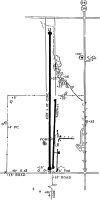
Runways
Runway Summary
| Runways: | 17/35 |
| Longest Runway: | 17/35 is 4557 ft (1389 m) long |
| Runways with an Instrument Approach: |
1K7 Airport Runway Details
| Runway 17/35 | 4557 ft x 60 ft (1389 m x 18 m) | |
| Runway Length Source: | FAA-EST IMAGERY as of 09/15/2020 | |
| Surface: | Concrete - Fair condition - No special surface treatment | |
| Runway Edge Lights: | Low Intensity | |
Runway 17 |
Runway 35 |
|
Elevation: |
882.0 | 877.0 |
Latitude: |
37-35-13.0600N | 37-34-28.0100N |
Longitude: |
095-50-13.6300W | 095-50-13.8900W |
|
Runway True Alignment: |
180 | 000 |
Glide Path Angle: |
0.0 degrees | 0.0 degrees |
Runway Markings Type: |
Nonprecision Instrument | Basic |
Runway Markings Condition: |
Fair | Fair |
Object at End: |
POLE | |
Object Height: |
35 | |
Distance from End: |
524 | |
Object Centerline Offset: |
107 ft. left of centerline | |
Threshold Elevation: |
878.0 | |
Displaced Threshold: |
541 | |
Threshold Latitude: |
37-34-33.3600N | |
Threshold Longitude: |
095-50-13.8600W |
Services
Airframe Repair: |
Major |
Powerplant Repair: |
Major |
Bottled Oxygen: |
None |
Bulk Oxygen: |
None |
Fuel Available: |
100LL, Jet A |
Landing Fees: |
No |
Parking: |
Hangars and tiedowns available |
Maps & Diagrams
1K7 Sectional
Flight Planning
at skyvector.com
at skyvector.com