Location
Latitude: |
37-51-05.8180N (37.851616) |
Longitude: |
096-17-31.2880W (-96.292024) |
Elevation: |
1208.1 feet MSL (368 m MSL) |
Magnetic Variation: |
2.4 E (as of April 2024 from WMM2020 model) |
Time Zone: |
UTC -6.0 (Standard Time) UTC -5.0 (Daylight Savings Time) |
From City: |
02 N.M. N of Eureka, Kansas |
Found On: |
Kansas City Chart |
FAA Region: |
ACE |
Contacts
Manager: |
Publicly owned: |
| CITY OF EUREKA MEMORIAL HALL EUREKA, KS 67045 620-583-6511 |
Operations
Airport Status: |
Operational |
Facility Use: |
Public |
Type: |
Airport |
Activation Date: |
07/1959 |
Control tower: |
No |
Attendance (Months/Days/Hours): |
Months/Days/Hours ALL/ALL/IREG |
Boundary ARTCC: |
ZKC (Kansas City) |
Responsible ARTCC: |
ZKC (Kansas City) |
Lighting Schedule: |
SEE RMK |
Segmented Circle Indicator: |
Yes |
Traffic Pattern Altitude (MSL): |
2208 feet (673 m) |
NOTAMs Facility: |
ICT |
NOTAM-D Service: |
Yes |
International Airport of Entry: |
No |
Customs Landing Rights: |
No |
Military Landing Rights: |
Yes |
Civil/Military Joint Use: |
No |
Based Aircraft
| Single Engine: | 12 |
| GA Helicopters: | 1 |
Annual Operations (as of 09/23/2020)
| Total Operations: | 4900 | |
| GA Local: | 3900 | 79.6% |
| GA Itinerant: | 1000 | 20.4% |
Communications
| CTAF: | 122.800 |
| Unicom: | 122.800 |
| AWOS-3PT: | 120.975 (620-583-2760) |
- APCH/DEP CTL SVC PRVDD BY KANSAS CITY ARTCC (ZKC) ON FREQS 120.2/323.2 (EMPORIA RCAG).
Fixed Based Operators (FBOs) & Fuel
(Click on a business for detail)
Please help us keep this information up to date. This is a FREE SERVICE just like everything else on Airport Guide! If you see that a business needs to be added, modified, or deleted please fill out our Update Form.
To add, modify, or delete a business click here.
Please help us keep this information up to date. This is a FREE SERVICE just like everything else on Airport Guide! If you see that a business needs to be added, modified, or deleted please fill out our Update Form.
Area Code: 620 |
| Business Name | Frequency | Phone | Fuel Grade |
|---|---|---|---|
| Kenneson Aircraft
Update FBO info |
Unicom 122.8 | 583-7732 | 100LL, MOGAS |
Flight Service Stations
| Primary | Alternate | |
| FSS on Field: | N | |
| FSS Name (ID): | Wichita(ICT) | |
| Frequency: | ||
| Toll Free Phone: | 1-800-WX-BRIEF |
Instrument Procedures / Charts
FAA Terminal Procedures valid from 0901Z 03/21/24 to 0901Z 04/18/24.
There are various types of charts available for an airport. They are listed in the Page Type column. Here is a legend for those types:
APD - Airport Diagram
DP - Departure Procedure Charts
HOT - Hot Spots
IAP - Instrument Approach Procedure Charts
MIN - Minimums
STAR - Standard Terminal Arrival Charts
| Page Type | Page Name | Volume | Action Since Last Cycle |
|---|---|---|---|
| IAP | RNAV (GPS) RWY 18 | NC-2 | |
| IAP | VOR/DME RWY 18 | NC-2 | |
| MIN | TAKEOFF MINIMUMS | NC-2 |
Terminal Procedures are only available for airports in several countries with more being added all the time. If you are looking for a specific country's charts, please send an email to support(at)airportguide.com stating the country name. This will be used to prioritize the implementation.
Navigation Aids (Navaids) near 13K
| Dist (NM) | ID | Morse Code | Name | Type | Freq | True Hdg | Mag Hdg |
|---|---|---|---|---|---|---|---|
| 27.4 | EMP | . _ _ . _ _ . | Emporia | VORTAC | 112.80 | 15 | 13 |
| 35.8 | CNU | _ . _ . _ . . . _ | Chanute | VOR-DME | 109.20 | 111 | 109 |
| 38.1 | UKL | . . _ _ . _ . _ . . | Boyd | NDB | 245 | 44 | 42 |
| 41.7 | MSB | _ _ . . . _ . . . | Monarch | NDB | 410 | 94 | 92 |
| 48.1 | EWK | . . _ _ _ . _ | Newton | NDB | 281 | 285 | 282 |
| 48.3 | IAB | . . . _ _ . . . | Mc Connell | TACAN | 116.50 | 253 | 250 |
| 49.7 | CA | _ . _ . . _ | Harvs | NDB | 395 | 291 | 288 |
| 55.7 | ICT | . . _ . _ . _ | Wichita | VOT | 114.00 | 256 | 253 |
| 56.1 | HRU | . . . . . _ . . . _ | Herington | NDB | 407 | 334 | 331 |
| 57.0 | CFV | _ . _ . . . _ . . . . _ | Coffeyville | NDB | 212 | 142 | 140 |
| 57.6 | IC | . . _ . _ . | Piche | NDB | 332 | 253 | 250 |
| 57.8 | SO | . . . _ _ _ | Sawcy | NDB | 353 | 218 | 215 |
| 61.1 | EGT | . _ _ . _ | Wellington | NDB | 414 | 239 | 236 |
| 61.6 | ICT | . . _ . _ . _ | Wichita | VORTAC | 113.80 | 264 | 261 |
| 62.2 | BV | _ . . . . . . _ | Dewie | NDB | 201 | 167 | 165 |
| 62.4 | BVO | _ . . . . . . _ _ _ _ | Bartlesville | VOR-DME | 117.90 | 167 | 165 |
| 66.5 | OSW | _ _ _ . . . . _ _ | Oswego | DME | 117.6 | 128 | 126 |
| 70.4 | FO | . . _ . _ _ _ | Riply | NDB | 326 | 28 | 26 |
| 72.1 | FOE | . . _ . _ _ _ . | Forbes | TACAN | 111.60 | 24 | 22 |
| 72.3 | FRI | . . _ . . _ . . . | Fort Riley | VOR | 109.40 | 338 | 335 |
Nearby Airports with Fuel
Notices to Airmen (NOTAMS)
Remarks
| A110-1 | WILDLIFE ON & INVOF ARPT. |
| A110-3 | FOR CD CTC KANSAS CITY ARTCC AT 913-254-8508. |
| A42-08 | WHITE TIRES MARK RY END. |
| A42-26 | WHITE TIRES MARK RY END. |
| A52-08 | PLINE AND POLES EXCEED RWY 26 APCH AND DEP SFCS. EXER CTN. |
| A53-08 | DELINEATED WITH WHITE PAINTED TIRES. |
| A57-08 | CONTROLLING OBSTN EXCEEDS A 45 DEG SLP. |
| A58-36 | GROUND DROPS DOWN ABRUPTLY 85 FT FM END OF RY. |
| A81-APT | ACTVT PAPI RWY 18; MIRL RWY 18/36 - CTAF. |
| E111 | A 20:1 APCH MAINTD OVR FENCE. |
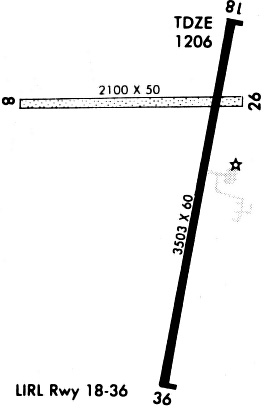
Runways
Runway Summary
| Runways: | 08/26 18/36 |
| Longest Runway: | 18/36 is 3504 ft (1068 m) long |
| Runways with an Instrument Approach: |
13K Airport Runway Details
| Runway 08/26 | 2143 ft x 55 ft (653 m x 17 m) | |
| Runway Length Source: | 3RD PARTY SURVEY as of 09/26/2019 | |
| Surface: | Turf - No special surface treatment | |
Runway 08 |
Runway 26 |
|
Elevation: |
1194.6 | 1208.1 |
Latitude: |
37-51-10.9363N | 37-51-11.8665N |
Longitude: |
096-17-48.0998W | 096-17-21.4070W |
|
Runway True Alignment: |
087 | 267 |
Glide Path Angle: |
0.0 degrees | 0.0 degrees |
Traffic Pattern: |
Left | Left |
Runway Markings Type: |
Nonstandard (other than numbers only) | Nonstandard (other than numbers only) |
Runway Markings Condition: |
Fair | Fair |
Object at End: |
FENCE | |
Object Height: |
4 | |
Object Marked/Lighted?: |
Marked | |
Distance from End: |
0 | |
Object Centerline Offset: |
0 ft. left and right of centerline | |
REIL: |
No | No |
Touchdown Lights: |
No | No |
Centerline Lights: |
No | No |
| Runway 18/36 | 3504 ft x 60 ft (1068 m x 18 m) | |
| Runway Length Source: | 3RD PARTY SURVEY as of 09/26/2019 | |
| Surface: | Turf - No special surface treatment | |
| Runway Pavement Class: | 3 /F/C/Y/U | |
| Runway Edge Lights: | Medium Intensity | |
Runway Weight Bearing Capacity (in thousands of pounds) |
||
| Single Wheel Landing Gear: | 8.0 | |
Runway 18 |
Runway 36 |
|
Elevation: |
1206.4 | 1195.6 |
Latitude: |
37-51-19.4263N | 37-50-45.3792N |
Longitude: |
096-17-25.1585W | 096-17-33.1782W |
|
Runway True Alignment: |
191 | 011 |
Glide Path Angle: |
3.0 degrees | 3.0 degrees |
Traffic Pattern: |
Left | Left |
Runway Markings Type: |
Nonprecision Instrument | Numbers Only |
Runway Markings Condition: |
Good | Good |
Object Centerline Offset: |
0 ft. left and right of centerline | |
Visual Glide Slope Indicators: |
2-Light PAPI On Left Side Of Runway | 2-Light PAPI On Left Side Of Runway |
REIL: |
No | No |
Touchdown Lights: |
No | No |
Centerline Lights: |
No | No |
Threshold Crossing Height: |
34 | 40 |
Services
Airframe Repair: |
None |
Powerplant Repair: |
None |
Bottled Oxygen: |
None |
Bulk Oxygen: |
None |
Fuel Available: |
100LL, Jet A |
Landing Fees: |
No |
Parking: |
Hangars and tiedowns available |
Maps & Diagrams
13K Sectional
Flight Planning
at skyvector.com
at skyvector.com