Location
Latitude: |
38-26-27.2000N (38.440889) |
Longitude: |
082-12-02.8000W (-82.200778) |
Elevation: |
571.7 feet MSL (174 m MSL) |
Magnetic Variation: |
7.5 W (as of April 2024 from WMM2020 model) |
Time Zone: |
UTC -5.0 (Standard Time) UTC -4.0 (Daylight Savings Time) |
From City: |
04 N.M. W of Milton, West Virginia |
Found On: |
Cincinnati Chart |
FAA Region: |
AEA |
Contacts
Manager: |
Privately owned: |
| BILL & LYNN BAUER # 1 FAIR SKIES DR. ONA, WV 25545-1500 (954) 328-7646 |
ONA LAND MANAGEMENT SERVICES, LLC #1 FAIR SKIES DR ONA, WV 25545-1500 (954) 328-7646 |
Operations
Airport Status: |
Operational |
Facility Use: |
Public |
Type: |
Airport |
Activation Date: |
09/1987 |
Control tower: |
No |
Attendance (Months/Days/Hours): |
Months/Days/Hours ALL/ALL/ALL |
Boundary ARTCC: |
ZID (Indianapolis) |
Responsible ARTCC: |
ZID (Indianapolis) |
Lighting Schedule: |
SS-SR |
Segmented Circle Indicator: |
No |
Traffic Pattern Altitude (MSL): |
1572 feet (479 m) |
NOTAMs Facility: |
EKN |
NOTAM-D Service: |
Yes |
Based Aircraft
| Single Engine: | 50 |
| Multi Engine: | 4 |
Annual Operations (as of 07/06/2022)
| Total Operations: | 6940 | |
| GA Local: | 5480 | 79.0% |
| GA Itinerant: | 1460 | 21.0% |
Communications
| CTAF: | 122.800 |
| Unicom: | 122.800 |
| Approach: | HUNTINGTON 124.1 ;EAST 124.1 ;EAST 124.1 ;EAST 124.1 ;EAST CHARLESTON |
| Departure: | HUNTINGTON 124.1 ;EAST 124.1 ;EAST 124.1 ;EAST 124.1 ;EAST CHARLESTON |
- APPROACHES FROM THE EAST USE CHARLESTON APCH 124.1/269.125. APPROACHES FROM THE WEST USE HUNTINGTON APCH 119.75/270.1.
Fixed Based Operators (FBOs) & Fuel
(Click on a business for detail)
Please help us keep this information up to date. This is a FREE SERVICE just like everything else on Airport Guide! If you see that a business needs to be added, modified, or deleted please fill out our Update Form.
To add, modify, or delete a business click here.
Please help us keep this information up to date. This is a FREE SERVICE just like everything else on Airport Guide! If you see that a business needs to be added, modified, or deleted please fill out our Update Form.
Area Code: 304 |
| Business Name | Frequency | Phone | Fuel Grade |
|---|
Flight Service Stations
| Primary | Alternate | |
| FSS on Field: | ||
| FSS Name (ID): | Elkins(EKN) | |
| Frequency: | ||
| Toll Free Phone: | 1-800-WX-BRIEF |
Instrument Procedures / Charts
FAA Terminal Procedures valid from 0901Z 03/21/24 to 0901Z 04/18/24.
There are various types of charts available for an airport. They are listed in the Page Type column. Here is a legend for those types:
APD - Airport Diagram
DP - Departure Procedure Charts
HOT - Hot Spots
IAP - Instrument Approach Procedure Charts
MIN - Minimums
STAR - Standard Terminal Arrival Charts
| Page Type | Page Name | Volume | Action Since Last Cycle |
|---|---|---|---|
| IAP | RNAV (GPS)-A | NE-4 | |
| IAP | VOR-A | NE-4 | |
| MIN | TAKEOFF MINIMUMS | NE-4 |
Terminal Procedures are only available for airports in several countries with more being added all the time. If you are looking for a specific country's charts, please send an email to support(at)airportguide.com stating the country name. This will be used to prioritize the implementation.
Navigation Aids (Navaids) near 12V
| Dist (NM) | ID | Morse Code | Name | Type | Freq | True Hdg | Mag Hdg |
|---|---|---|---|---|---|---|---|
| 20.5 | HNN | . . . . _ . _ . | Henderson | DME | 115.9 | 23 | 31 |
| 21.0 | HVQ | . . . . . . . _ _ _ . _ | Charleston | VOR-DME | 117.40 | 104 | 112 |
| 28.9 | CRW | _ . _ . . _ . . _ _ | Charleston | VOT | 108.80 | 97 | 105 |
| 37.5 | ECB | . _ . _ . _ . . . | Newcombe | DME | 110.4 | 243 | 250 |
| 38.5 | YRK | _ . _ _ . _ . _ . _ | York | VORTAC | 112.80 | 288 | 295 |
| 41.9 | GTC | _ _ . _ _ . _ . | Guyandot | NDB | 293 | 160 | 168 |
| 47.1 | UNI | . . _ _ . . . | Athens | FAN MARKER | 0 | 8 | |
| 49.1 | UGS | . . _ _ _ . . . . | University | NDB | 250 | 4 | 12 |
| 55.4 | EOP | . _ _ _ . _ _ . | Waverly | NDB | 385 | 322 | 329 |
| 59.2 | PK | . _ _ . _ . _ | Versi | NDB | 388 | 34 | 42 |
| 60.1 | PZO | . _ _ . _ _ . . _ _ _ | Peebles | NDB | 329 | 299 | 306 |
| 64.5 | BKW | _ . . . _ . _ . _ _ | Beckley | VOR-DME | 117.70 | 127 | 135 |
| 67.5 | PKB | . _ _ . _ . _ _ . . . | Marietta Ohio | FAN MARKER | 32 | 40 | |
| 68.4 | XW | _ . . _ . _ _ | Flmng | NDB | 400 | 277 | 284 |
| 68.5 | AMT | . _ _ _ _ | West Union | NDB | 359 | 291 | 298 |
| 71.2 | RZT | . _ . _ _ . . _ | Ross County | NDB | 236 | 327 | 334 |
| 71.3 | JPU | . _ _ _ . _ _ . . . _ | Parkersburg | VOR-DME | 114.45 | 32 | 40 |
| 71.4 | RNL | . _ . _ . . _ . . | Rainelle | VOR | 116.60 | 112 | 120 |
| 74.6 | XUB | _ . . _ . . _ _ . . . | Yellow Bud | VOR | 112.50 | 331 | 338 |
| 77.0 | HOC | . . . . _ _ _ _ . _ . | Hillsboro | NDB | 278 | 305 | 312 |
Nearby Airports with Fuel
Notices to Airmen (NOTAMS)
Remarks
| A110*G | THIS AIRPORT HAS BEEN SURVEYED BY THE NATIONAL GEODETIC SURVEY. |
| A110-10 | VEHICLES CROSSING RWY. |
| A110-12 | FOR CD CTC HUNTINGTON ATCT AT 304-453-2490. |
| A110-3 | NOISE ABATEMENT PROCEDURES IN EFFECT; DEP RWY 25 FLY 240 DEGS & DEP RWY 07 FLY 090 DEGS TO 1600 FT ALTITUDE. |
| A110-4 | RWY EXIT TO RAMP HAS DEPRESSION. |
| A110-6 | (A52-09) +350 HILL 1300 FT DSTC. |
| A110-7 | FENCE, POLES, BLDGS, IN PRIMARY SFC, WEST SIDE. |
| A110-8 | RACE TRACK ADJACENT TO RWY 07/25. |
| A40-07/25 | NSTD LIRL LIGHTS, NSTD SPACING AND COLORS. |
| A42-07 | MARKINGS FADED. NUMBERS ONLY. NO CNTRLN MKGS. |
| A42-25 | MARKINGS FADED. NUMBERS ONLY. NO CNTRLN MKGS. |
| A52-25 | ALSO +350 FT HILL 1300 FT DISTANCE. |
| A57-07 | ACTUAL OBSTN CLNC SLOPE IS 0:1. |
| A58-25 | 20 FT HILL, 200 FT FM RWY END, 172 FT RIGHT, 40 FT TREES, 200 DSTC, 60-247 FT L. |
| A70-FUEL-10 | 0LL 24 HR SELF-SERVE. |
Runways
Runway Summary
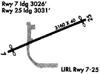
| Runways: | 07/25 |
| Longest Runway: | 07/25 is 3154 ft (961 m) long |
| Runways with an Instrument Approach: |
12V Airport Runway Details
| Runway 07/25 | 3154 ft x 40 ft (961 m x 12 m) | |
| Surface: | Asphalt - Fair condition - No special surface treatment | |
| Runway Edge Lights: | Non-standard lighting system Intensity | |
Runway 07 |
Runway 25 |
|
Elevation: |
567.1 | 569.4 |
Latitude: |
38-26-19.2290N | 38-26-35.1610N |
Longitude: |
082-12-19.8080W | 082-11-45.7380W |
|
Runway True Alignment: |
059 | 239 |
Glide Path Angle: |
0.0 degrees | 0.0 degrees |
Runway Markings Type: |
Basic | Basic |
Runway Markings Condition: |
Fair | Fair |
Object at End: |
TREES | TREES |
Object Height: |
75 | 40 |
Distance from End: |
615 | 201 |
Object Centerline Offset: |
28 ft. left of centerline | 60 ft. left of centerline |
Services
Fuel Available: |
80 |
Landing Fees: |
No |
Parking: |
Tiedowns available |
Maps & Diagrams
12V Sectional
Flight Planning
at skyvector.com
at skyvector.com