Location
Latitude: |
44-00-59.1000N (44.016417) |
Longitude: |
097-05-08.2000W (-97.085611) |
Elevation: |
1718.4 feet MSL (524 m MSL) |
Magnetic Variation: |
2.9 E (as of April 2024 from WMM2020 model) |
Time Zone: |
UTC -6.0 (Standard Time) UTC -5.0 (Daylight Savings Time) |
From City: |
01 N.M. NE of Madison, South Dakota |
Found On: |
Omaha Chart |
FAA Region: |
AGL |
Contacts
Manager: |
Publicly owned: |
| MORRIS RIGGIN 1600 AIRPORT DRIVE MADISON, SD 57042 605-256-9774 |
CITY OF MADISON 116 W. CENTER MADISON, SD 57042 605-256-7500 |
Operations
Airport Status: |
Operational |
Facility Use: |
Public |
Type: |
Airport |
Activation Date: |
01/1965 |
Control tower: |
No |
Attendance (Months/Days/Hours): |
Months/Days/Hours ALL/7 DAYS A WEEK/0700-1800 |
Boundary ARTCC: |
ZMP (Minneapolis) |
Responsible ARTCC: |
ZMP (Minneapolis) |
Lighting Schedule: |
SEE RMK |
Segmented Circle Indicator: |
No |
Traffic Pattern Altitude (MSL): |
2718 feet (828 m) |
NOTAMs Facility: |
HON |
NOTAM-D Service: |
Yes |
International Airport of Entry: |
No |
Customs Landing Rights: |
No |
Military Landing Rights: |
Yes |
Civil/Military Joint Use: |
No |
Based Aircraft
| Single Engine: | 48 |
| Multi Engine: | 5 |
| GA Helicopters: | 2 |
| Gliders: | 2 |
Annual Operations (as of 04/18/2023)
| Total Operations: | 37895 | |
| Air Taxi: | 60 | 0.2% |
| GA Local: | 34500 | 91.0% |
| GA Itinerant: | 3335 | 8.8% |
Communications
| CTAF: | 122.800 |
| Unicom: | 122.800 |
| AWOS-3: | 118.35 (605-427-9380) |
- APCH/DEP SVC PRVDD BY MINNEAPOLIS ARTCC ON FREQS 132.050/317.4 (SIOUX FALLS RCAG).
Fixed Based Operators (FBOs) & Fuel
(Click on a business for detail)
Please help us keep this information up to date. This is a FREE SERVICE just like everything else on Airport Guide! If you see that a business needs to be added, modified, or deleted please fill out our Update Form.
To add, modify, or delete a business click here.
Please help us keep this information up to date. This is a FREE SERVICE just like everything else on Airport Guide! If you see that a business needs to be added, modified, or deleted please fill out our Update Form.
Area Code: 605 |
| Business Name | Frequency | Phone | Fuel Grade |
|---|---|---|---|
| Dakota Wings Corporation
Update FBO info |
Unicom 122.95 | 256-9737 | 100LL, Jet A, MOGAS |
| Madison Aircraft
Update FBO info |
Unicom 122.8 | 256-9774 | 100LL, MOGAS |
Flight Service Stations
| Primary | Alternate | |
| FSS on Field: | N | |
| FSS Name (ID): | Huron(HON) | |
| Frequency: | ||
| Toll Free Phone: | 1-800-WX-BRIEF |
Instrument Procedures / Charts
FAA Terminal Procedures valid from 0901Z 03/21/24 to 0901Z 04/18/24.
There are various types of charts available for an airport. They are listed in the Page Type column. Here is a legend for those types:
APD - Airport Diagram
DP - Departure Procedure Charts
HOT - Hot Spots
IAP - Instrument Approach Procedure Charts
MIN - Minimums
STAR - Standard Terminal Arrival Charts
| Page Type | Page Name | Volume | Action Since Last Cycle |
|---|---|---|---|
| IAP | RNAV (GPS) RWY 15 | NC-1 | |
| IAP | RNAV (GPS) RWY 33 | NC-1 | |
| MIN | ALTERNATE MINIMUMS | NC-1 | |
| MIN | TAKEOFF MINIMUMS | NC-1 |
Terminal Procedures are only available for airports in several countries with more being added all the time. If you are looking for a specific country's charts, please send an email to support(at)airportguide.com stating the country name. This will be used to prioritize the implementation.
Navigation Aids (Navaids) near XMD
| Dist (NM) | ID | Morse Code | Name | Type | Freq | True Hdg | Mag Hdg |
|---|---|---|---|---|---|---|---|
| 0.2 | MDS | _ _ _ . . . . . | Wentworth | NDB | 400 | 212 | 209 |
| 20.8 | BKX | _ . . . _ . _ _ . . _ | Brookings | VOR-DME | 108.80 | 33 | 30 |
| 21.1 | BK | _ . . . _ . _ | Chrlz | NDB | 335 | 16 | 13 |
| 25.7 | FSD | . . _ . . . . _ . . | Sioux Falls | VORTAC | 115.00 | 148 | 145 |
| 33.3 | FS | . . _ . . . . | Rokky | NDB | 245 | 160 | 157 |
| 43.6 | MHE | _ _ . . . . . | Mitchell | VOR-DME | 109.20 | 251 | 248 |
| 47.3 | AT | . _ _ | Lican | NDB | 215 | 356 | 353 |
| 57.8 | ATY | . _ _ _ . _ _ | Watertown | TACAN | 116.60 | 357 | 354 |
| 58.3 | GB | _ _ . _ . . . | Garno | NDB | 253 | 59 | 57 |
| 58.5 | HON | . . . . _ _ _ _ . | Huron | DME | 117.6 | 296 | 293 |
| 59.6 | HO | . . . . _ _ _ | Beady | NDB | 302 | 295 | 292 |
| 60.1 | MML | _ _ _ _ . _ . . | Marshall | VOR-DME | 111.00 | 64 | 62 |
| 65.8 | SOY | . . . _ _ _ _ . _ _ | Sioux Center | NDB | 368 | 143 | 140 |
| 67.2 | YKN | _ . _ _ _ . _ _ . | Yankton | DME | 111.4 | 191 | 188 |
| 68.8 | OTG | _ _ _ _ _ _ . | Worthington | DME | 110.6 | 108 | 106 |
| 69.7 | ISB | . . . . . _ . . . | Sibley | NDB | 269 | 123 | 121 |
| 69.8 | DXX | _ . . _ . . _ _ . . _ | Dawson/Madison | NDB | 341 | 33 | 30 |
| 71.0 | YK | _ . _ _ _ . _ | Cagur | NDB | 347 | 187 | 184 |
| 72.6 | SHL | . . . . . . . . _ . . | Sheldon | NDB | 338 | 131 | 129 |
| 74.2 | OT | _ _ _ _ | Wondd | NDB | 277 | 108 | 106 |
Nearby Airports with Fuel
Notices to Airmen (NOTAMS)
Remarks
| A110-2 | ULTRA-LIGHT ACTIVITY ON AND INVOF ARPT. |
| A110-3 | GCO AVBL ON FREQ 121.725 (4 CLICKS TO MINNEAPOLIS CENTER AND 6 CLICKS TO FLT SVCS) |
| A110-4 | FOR CD IF UNA VIA GCO CTC MINNEAPOLIS ARTCC AT 651-463-5588. |
| A30-03/21 | RY 03 21 CLSD 1 NOV-1 APR EXCEPT WITH PPR CALL 605-256-9774. |
| A42-03 | RY 03/21 MKD WITHBLACK & WHITE CONES. |
| A81-APT | ACTVT MIRL RY 15/33 & REIL RY 15 & 33 - CTAF. |
Runways
Runway Summary
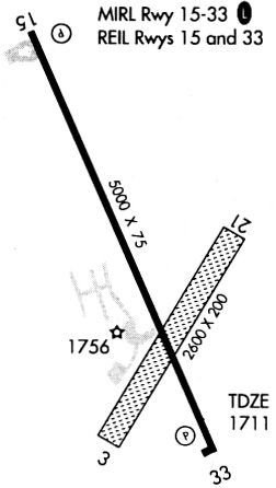
| Runways: | 03/21 15/33 |
| Longest Runway: | 15/33 is 5000 ft (1524 m) long |
| Runways with an Instrument Approach: |
XMD Airport Runway Details
| Runway 03/21 | 2380 ft x 200 ft (725 m x 61 m) | |
| Runway Length Source: | 3RD PARTY SURVEY as of 08/03/2011 | |
| Surface: | Turf - Good condition - No special surface treatment | |
Runway 03 |
Runway 21 |
|
Elevation: |
1714.7 | 1708.3 |
Latitude: |
44-00-46.8023N | 44-01-06.1484N |
Longitude: |
097-05-09.2051W | 097-04-50.7180W |
|
Runway True Alignment: |
034 | 214 |
Glide Path Angle: |
0.0 degrees | 0.0 degrees |
Traffic Pattern: |
Left | Left |
REIL: |
No | No |
Touchdown Lights: |
No | No |
Centerline Lights: |
No | No |
| Runway 15/33 | 5000 ft x 75 ft (1524 m x 23 m) | |
| Runway Length Source: | 3RD PARTY SURVEY as of 08/03/2011 | |
| Surface: | Turf - Good condition - No special surface treatment | |
| Runway Pavement Class: | 20 /R/D/Y/T | |
| Runway Edge Lights: | Medium Intensity | |
Runway Weight Bearing Capacity (in thousands of pounds) |
||
| Single Wheel Landing Gear: | 56.0 | |
| Dual Wheel Landing Gear: | 69.0 | |
Runway 15 |
Runway 33 |
|
Elevation: |
1718.4 | 1709.4 |
Latitude: |
44-01-22.4883N | 44-00-38.2118N |
Longitude: |
097-05-27.2268W | 097-04-56.9582W |
|
Runway True Alignment: |
154 | 334 |
Glide Path Angle: |
3.0 degrees | 3.0 degrees |
Traffic Pattern: |
Left | Left |
Runway Markings Type: |
Nonprecision Instrument | Nonprecision Instrument |
Runway Markings Condition: |
Good | Good |
Object at End: |
TREES | |
Object Height: |
40 | |
Distance from End: |
1300 | |
Visual Glide Slope Indicators: |
4-Light PAPI On Left Side Of Runway | 4-Light PAPI On Left Side Of Runway |
REIL: |
Yes | Yes |
Touchdown Lights: |
No | No |
Centerline Lights: |
No | No |
Threshold Crossing Height: |
32 | 39 |
Services
Airframe Repair: |
Minor |
Powerplant Repair: |
Minor |
Bottled Oxygen: |
None |
Bulk Oxygen: |
None |
Fuel Available: |
100LL |
Landing Fees: |
No |
Parking: |
Hangars and tiedowns available |
Maps & Diagrams
XMD Sectional
Flight Planning
at skyvector.com
at skyvector.com