Location
Latitude: |
25-29-57.2170N (25.499227) |
Longitude: |
080-33-15.2880W (-80.554247) |
Elevation: |
7.0 feet MSL (2 m MSL) |
Magnetic Variation: |
6.9 W (as of April 2024 from WMM2020 model) |
Time Zone: |
UTC -5.0 (Standard Time) UTC -4.0 (Daylight Savings Time) |
From City: |
04 N.M. NW of Homestead, Florida |
Found On: |
Miami Chart |
FAA Region: |
ASO |
Contacts
Manager: |
Publicly owned: |
| JONATHAN SPICER 12800 SOUTHWEST 145TH AVENUE MIAMI, FL 33186 (305) 869-1702 |
MIAMI-DADE COUNTY MIAMI-DADE AVIATION DEPARTMENT, P.O. BOX 025504 MIAMI, FL 33102-5504 305-876-0464 |
Operations
Airport Status: |
Operational |
Facility Use: |
Public |
Type: |
Airport |
Activation Date: |
04/1963 |
Control tower: |
No |
Attendance (Months/Days/Hours): |
Months/Days/Hours ALL/ALL/ALL |
Boundary ARTCC: |
ZMA (Miami) |
Responsible ARTCC: |
ZMA (Miami) |
Lighting Schedule: |
SS-SR |
Segmented Circle Indicator: |
Yes, Lighted |
Traffic Pattern Altitude (MSL): |
1007 feet (307 m) |
NOTAMs Facility: |
MIA |
NOTAM-D Service: |
Yes |
International Airport of Entry: |
No |
Customs Landing Rights: |
No |
Military Landing Rights: |
Yes |
Civil/Military Joint Use: |
No |
Based Aircraft
| Single Engine: | 19 |
| Gliders: | 2 |
| Ultralights: | 1 |
Annual Operations (as of 05/04/2018)
| Total Operations: | 76617 | |
| Air Taxi: | 2100 | 2.7% |
| GA Local: | 46582 | 60.8% |
| GA Itinerant: | 26451 | 34.5% |
| Military Aircraft: | 1484 | 1.9% |
Communications
| CTAF: | 122.800 |
| Unicom: | 122.800 |
| Approach: | MIAMI |
| Departure: | MIAMI |
| AWOS-3: | 118.375 (305-247-2791) |
Fixed Based Operators (FBOs) & Fuel
(Click on a business for detail)
Please help us keep this information up to date. This is a FREE SERVICE just like everything else on Airport Guide! If you see that a business needs to be added, modified, or deleted please fill out our Update Form.
To add, modify, or delete a business click here.
Please help us keep this information up to date. This is a FREE SERVICE just like everything else on Airport Guide! If you see that a business needs to be added, modified, or deleted please fill out our Update Form.
Area Code: 305 |
| Business Name | Frequency | Phone | Fuel Grade |
|---|---|---|---|
| Miami-Dade Aviation Department
Update FBO info |
876-7862, night phone 247-4883 | ||
| Roberts Air South, Inc.
Website Update FBO info |
122.8 | 305-246-0179 | 100LL, Jet A |

|
AvFuel | 100LL - 4.90 USD per gallon on 02/10/2021 |
24 Hour Self-Serve Credit Card Pumps |
|
|
AvFuel | Jet A+ - 4.45 USD per gallon on 02/22/2021 |
24 Hour Self-Serve Credit Card Pumps |
| Skydive Miami, Inc.
Update FBO info |
759-3483 | ||
| Wyatt Aviation
Update FBO info |
123.3 | 305-247-7757 | 100LL, Jet A |
Flight Service Stations
| Primary | Alternate | |
| FSS on Field: | N | |
| FSS Name (ID): | Miami(MIA) | |
| Frequency: | ||
| Toll Free Phone: | 1-800-WX-BRIEF |
Instrument Procedures / Charts
FAA Terminal Procedures valid from 0901Z 03/21/24 to 0901Z 04/18/24.
There are various types of charts available for an airport. They are listed in the Page Type column. Here is a legend for those types:
APD - Airport Diagram
DP - Departure Procedure Charts
HOT - Hot Spots
IAP - Instrument Approach Procedure Charts
MIN - Minimums
STAR - Standard Terminal Arrival Charts
Terminal Procedures are only available for airports in several countries with more being added all the time. If you are looking for a specific country's charts, please send an email to support(at)airportguide.com stating the country name. This will be used to prioritize the implementation.
Navigation Aids (Navaids) near X51
| Dist (NM) | ID | Morse Code | Name | Type | Freq | True Hdg | Mag Hdg |
|---|---|---|---|---|---|---|---|
| 9.0 | TM | _ _ _ | Qeezy | NDB | 266 | 17 | 24 |
| 9.5 | HST | . . . . . . . _ | Homestead | TACAN | 108.20 | 93 | 100 |
| 21.2 | DHP | _ . . . . . . . _ _ . | Dolphin | VORTAC | 113.90 | 31 | 38 |
| 23.2 | MIA | _ _ . . . _ | Miami Intl | VOT | 112.00 | 39 | 46 |
| 26.4 | VKZ | . . . _ _ . _ _ _ . . | Virginia Key | VOR-DME | 117.10 | 54 | 61 |
| 32.9 | TN | _ _ . | Monry | NDB | 227 | 311 | 318 |
| 40.3 | FLL | . . _ . . _ . . . _ . . | Fort Lauderdale | VOR-DME | 114.40 | 31 | 38 |
| 43.4 | FX | . . _ . _ . . _ | Praiz | NDB | 221 | 18 | 25 |
| 55.6 | MTH | _ _ _ . . . . | Marathon | NDB | 260 | 212 | 219 |
| 69.3 | ZBV | _ _ . . _ . . . . . . _ | Bimini | VORTAC | 116.70 | 79 | 86 |
| 75.2 | PBI | . _ _ . _ . . . . . | Palm Beach | VORTAC | 115.70 | 19 | 26 |
| 75.3 | PBI | . _ _ . _ . . . . . | Palm Beach | VOT | 109.00 | 18 | 25 |
| 76.9 | CYY | _ . _ . _ . _ _ _ . _ _ | Cypress | VOR-DME | 108.60 | 300 | 307 |
| 77.4 | PHK | . _ _ . . . . . _ . _ | Pahokee | VOR-DME | 115.40 | 354 | 361 |
| 82.5 | NQX | _ . _ _ . _ _ . . _ | Key West | TACAN | 113.10 | 228 | 235 |
| 85.4 | UTX | . . _ _ _ . . _ | United | NDB | 405 | 7 | 14 |
| 87.1 | EYW | . _ . _ _ . _ _ | Key West | VORTAC | 113.50 | 231 | 238 |
| 88.0 | FIS | . . _ . . . . . . | Fish Hook | NDB | 332 | 229 | 236 |
| 90.3 | RSW | . _ . . . . . _ _ | Lee County | VORTAC | 114.15 | 313 | 320 |
| 91.6 | LBV | . _ . . _ . . . . . . _ | La Belle | VORTAC | 110.40 | 330 | 337 |
Nearby Airports with Fuel
Notices to Airmen (NOTAMS)
Remarks
| A11 | LONNY CRAVEN |
| A110-1 | PAJA SE CORNER OF ARPT . |
| A110-4 | AEROBATIC BOX S OF ARPT & E OF RWY 18/36. |
| A110-6 | REMOTE CTL MODEL FLYING FLDS 1.8 NM N RWY 18. |
| A110-8 | GLIDER ACT 8000 FT & BLW & CROP DUSTING INVOF ARPT. |
| A110-9 | FOR CD CTC MIAMI APCH AT 305-869-5432. |
| A42-09U | MKD WITH WHITE CONES. |
| A42-27U | MKD WITH WHITE CONES. |
| E111 | VFR ONLY. |
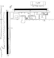
Runways
Runway Summary
| Runways: | 09U/27U 10/28 18/36 |
| Longest Runway: | 18/36 is 4001 ft (1220 m) long |
| Runways with an Instrument Approach: |
X51 Airport Runway Details
| Runway 09U/27U | 2500 ft x 150 ft (762 m x 46 m) | |
| Runway Length Source: | STATE as of 01/05/2011 | |
| Surface: | Turf - Fair condition - No special surface treatment | |
Runway 09U |
Runway 27U |
|
Glide Path Angle: |
0.0 degrees | 0.0 degrees |
Runway Markings Type: |
Nonstandard (other than numbers only) | Nonstandard (other than numbers only) |
Runway Markings Condition: |
Good | Good |
Object at End: |
TREES | |
Object Height: |
46 | |
Distance from End: |
2270 | |
Object Centerline Offset: |
40 ft. left of centerline |
| Runway 10/28 | 3000 ft x 75 ft (914 m x 23 m) | |
| Runway Length Source: | OWNER as of 05/12/2009 | |
| Surface: | Turf - Fair condition - Saw-cut or plastic grooved | |
| Runway Pavement Class: | 5 /F/A/Y/T | |
| Runway Edge Lights: | Medium Intensity | |
Runway Weight Bearing Capacity (in thousands of pounds) |
||
| Single Wheel Landing Gear: | 20.0 | |
Runway 10 |
Runway 28 |
|
Elevation: |
6.0 | 6.9 |
Latitude: |
25-30-09.8352N | 25-30-09.9967N |
Longitude: |
080-33-18.3516W | 080-32-45.6445W |
|
Runway True Alignment: |
090 | 270 |
Glide Path Angle: |
3.0 degrees | 0.0 degrees |
Traffic Pattern: |
Left | Right |
Runway Markings Type: |
Nonprecision Instrument | Nonprecision Instrument |
Runway Markings Condition: |
Good | Good |
Object at End: |
TREE | |
Object Height: |
22 | |
Distance from End: |
1270 | |
Object Centerline Offset: |
40 ft. left of centerline | |
Visual Glide Slope Indicators: |
2-Light PAPI On Left Side Of Runway | |
Threshold Crossing Height: |
71 |
| Runway 18/36 | 4001 ft x 100 ft (1220 m x 30 m) | |
| Runway Length Source: | ADO as of 07/14/2021 | |
| Surface: | Turf - Fair condition - No special surface treatment | |
| Runway Pavement Class: | 12 /F/A/Y/T | |
| Runway Edge Lights: | Medium Intensity | |
Runway Weight Bearing Capacity (in thousands of pounds) |
||
| Single Wheel Landing Gear: | 40.0 | |
| Dual Wheel Landing Gear: | 65.0 | |
| Dual Tandem Wheel Landing Gear: | 110.0 | |
Runway 18 |
Runway 36 |
|
Elevation: |
6.9 | 7.0 |
Latitude: |
25-30-07.5168N | 25-29-27.8919N |
Longitude: |
080-33-25.4394W | 080-33-25.0470W |
|
Runway True Alignment: |
179 | 359 |
Glide Path Angle: |
0.0 degrees | 3.0 degrees |
Traffic Pattern: |
Right | Left |
Runway Markings Type: |
Basic | Basic |
Runway Markings Condition: |
Good | Good |
Object Centerline Offset: |
40 ft. left of centerline | |
Visual Glide Slope Indicators: |
4-Light PAPI On Right Side Of Runway | |
Threshold Crossing Height: |
24 |
Services
Airframe Repair: |
Major |
Powerplant Repair: |
Major |
Fuel Available: |
100LL, Jet A |
Parking: |
Hangars and tiedowns available |
Maps & Diagrams
X51 Sectional
Flight Planning
at skyvector.com
at skyvector.com