Location
Latitude: |
32-14-20.9220N (32.239145) |
Longitude: |
090-55-41.5020W (-90.928195) |
Elevation: |
107.0 feet MSL (33 m MSL) |
Magnetic Variation: |
1 W (as of April 2024 from WMM2020 model) |
Time Zone: |
UTC -6.0 (Standard Time) UTC -5.0 (Daylight Savings Time) |
From City: |
07 N.M. SW of Vicksburg, Mississippi |
Found On: |
Memphis Chart |
FAA Region: |
ASO |
Contacts
Manager: |
Publicly owned: |
| RON DAVIS 5855 HIGHWAY 61 SOUTH VICKSBURG, MS 39180 601-218-5789 |
CITY OF VICKSBURG PO BOX 150 VICKSBURG, MS 39180 601-634-4525 |
Operations
Airport Status: |
Operational |
Facility Use: |
Public |
Type: |
Airport |
Activation Date: |
03/1950 |
Control tower: |
No |
Attendance (Months/Days/Hours): |
Months/Days/Hours ALL/MON-FRI/0600-1700 |
Boundary ARTCC: |
ZME (Memphis) |
Responsible ARTCC: |
ZME (Memphis) |
Lighting Schedule: |
SEE RMK |
Segmented Circle Indicator: |
Yes |
Traffic Pattern Altitude (MSL): |
1107 feet (337 m) |
NOTAMs Facility: |
GWO |
NOTAM-D Service: |
Yes |
International Airport of Entry: |
No |
Customs Landing Rights: |
No |
Military Landing Rights: |
Yes |
Civil/Military Joint Use: |
No |
Based Aircraft
| Single Engine: | 9 |
| Multi Engine: | 2 |
| GA Helicopters: | 1 |
Annual Operations (as of 02/01/2023)
| Total Operations: | 1525 | |
| GA Local: | 950 | 62.3% |
| GA Itinerant: | 419 | 27.5% |
| Military Aircraft: | 156 | 10.2% |
Communications
| CTAF: | 122.800 |
| Unicom: | 122.800 |
| AWOS-3: | 118.85 (601-801-5376) |
- APCH/DEP SVC PRVDD BY MEMPHIS ARTCC ON FREQS 132.5/259.1 (GREENWOOD & JACKSON RCAGS).
Fixed Based Operators (FBOs) & Fuel
(Click on a business for detail)
Please help us keep this information up to date. This is a FREE SERVICE just like everything else on Airport Guide! If you see that a business needs to be added, modified, or deleted please fill out our Update Form.
To add, modify, or delete a business click here.
Please help us keep this information up to date. This is a FREE SERVICE just like everything else on Airport Guide! If you see that a business needs to be added, modified, or deleted please fill out our Update Form.
Area Code: 601 |
| Business Name | Frequency | Phone | Fuel Grade |
|---|---|---|---|
| General Aviation Svcs of Mississippi
Update FBO info |
Unicom 122.8 | 636-4925 | 100LL, Jet A |
Flight Service Stations
| Primary | Alternate | |
| FSS on Field: | N | |
| FSS Name (ID): | Greenwood(GWO) | |
| Frequency: | ||
| Toll Free Phone: | 1-800-WX-BRIEF |
Instrument Procedures / Charts
FAA Terminal Procedures valid from 0901Z 03/21/24 to 0901Z 04/18/24.
There are various types of charts available for an airport. They are listed in the Page Type column. Here is a legend for those types:
APD - Airport Diagram
DP - Departure Procedure Charts
HOT - Hot Spots
IAP - Instrument Approach Procedure Charts
MIN - Minimums
STAR - Standard Terminal Arrival Charts
| Page Type | Page Name | Volume | Action Since Last Cycle |
|---|---|---|---|
| IAP | RNAV (GPS) RWY 01 | SC-4 | |
| IAP | RNAV (GPS) RWY 19 | SC-4 | |
| MIN | ALTERNATE MINIMUMS | SC-4 | |
| MIN | TAKEOFF MINIMUMS | SC-4 |
Terminal Procedures are only available for airports in several countries with more being added all the time. If you are looking for a specific country's charts, please send an email to support(at)airportguide.com stating the country name. This will be used to prioritize the implementation.
Navigation Aids (Navaids) near VKS
| Dist (NM) | ID | Morse Code | Name | Type | Freq | True Hdg | Mag Hdg |
|---|---|---|---|---|---|---|---|
| 5.0 | TKH | _ _ . _ . . . . | Tallulah | NDB | 344 | 274 | 275 |
| 26.5 | RYB | . _ . _ . _ _ _ . . . | Raymond | NDB | 375 | 81 | 82 |
| 35.4 | JH | . _ _ _ . . . . | Brenz | NDB | 260 | 72 | 73 |
| 37.8 | HAH | . . . . . _ . . . . | Natchez-Adams County | NDB | 388 | 209 | 210 |
| 37.9 | BLE | _ . . . . _ . . . | Lake Providence | NDB | 278 | 339 | 340 |
| 41.8 | JAN | . _ _ _ . _ _ . | Jackson | VORTAC | 112.60 | 67 | 68 |
| 41.8 | HEZ | . . . . . _ _ . . | Natchez | VOR-DME | 110.00 | 207 | 208 |
| 42.3 | JA | . _ _ _ . _ | Allen | NDB | 365 | 75 | 76 |
| 43.6 | MHZ | _ _ . . . . _ _ . . | Magnolia | VORTAC | 113.20 | 74 | 75 |
| 44.0 | JAN | . _ _ _ . _ _ . | Jackson | VOT | 111.00 | 84 | 85 |
| 44.3 | MRK | _ _ . _ . _ . _ | Molly Ridge | NDB | 338 | 283 | 284 |
| 57.4 | BQP | _ . . . _ _ . _ . _ _ . | Bastrop | NDB | 329 | 302 | 303 |
| 58.6 | MLU | _ _ . _ . . . . _ | Monroe | VORTAC | 117.20 | 286 | 287 |
| 61.0 | ML | _ _ . _ . . | Sabar | NDB | 392 | 282 | 283 |
| 62.8 | MC | _ _ _ . _ . | Ferni | NDB | 413 | 160 | 161 |
| 65.7 | MCB | _ _ _ . _ . _ . . . | Mc Comb | VORTAC | 116.70 | 148 | 149 |
| 71.2 | MTQ | _ _ _ _ _ . _ | Metcalf | NDB | 359 | 357 | 358 |
| 77.1 | GLH | _ _ . . _ . . . . . . | Greenville | VOR-DME | 114.25 | 357 | 358 |
| 80.5 | SQS | . . . _ _ . _ . . . | Sidon | VORTAC | 114.70 | 23 | 24 |
| 84.8 | TUF | _ . . _ . . _ . | Stuckey | NDB | 350 | 277 | 277 |
Nearby Airports with Fuel
Notices to Airmen (NOTAMS)
Remarks
| A110-1 | N PARL TWY CLSD. |
| A110-4 | TERM STUB TWY ONLY. |
| A110-6 | FOR CD CTC MEMPHIS ARTCC AT 901-368-8453/8449. |
| A16 | OR 601-636-4925. |
| A17 | AFT HRS CALL 601-218-5428. CALL OUT FEE RQRD. |
| A57-01 | APCH RATIO 28:1 TO DTHR. |
| A57-19 | APCH RATIO 41:1 TO DTHR. |
| A70-FUEL-10 | 0LL FUEL 24 HRS WITH CREDIT CARD. |
| A71 | AVBL 601-529-2909. |
| A72 | AVBL 601-529-2909. |
| A75 | HNGR FEE RQRD. |
| A81-APT | ACTVT PAPI RWY 19; MIRL RWY 01/19 - CTAF. PAPI RWY 01 OPR CONSLY. |
| E111 | EXISTED PRIOR TO 1959. |
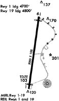
Runways
Runway Summary
| Runways: | 01/19 |
| Longest Runway: | 01/19 is 5000 ft (1524 m) long |
| Runways with an Instrument Approach: |
VKS Airport Runway Details
| Runway 01/19 | 5000 ft x 100 ft (1524 m x 30 m) | |
| Runway Length Source: | 3RD PARTY SURVEY as of 07/15/2020 | |
| Surface: | Asphalt - Fair condition - No special surface treatment | |
| Runway Edge Lights: | Medium Intensity | |
Runway Weight Bearing Capacity (in thousands of pounds) |
||
| Single Wheel Landing Gear: | 30.0 | |
| Dual Wheel Landing Gear: | 50.0 | |
| Dual Tandem Wheel Landing Gear: | 90.0 | |
Runway 01 |
Runway 19 |
|
Elevation: |
100.4 | 106.6 |
Latitude: |
32-13-56.4017N | 32-14-45.4422N |
Longitude: |
090-55-45.3320W | 090-55-37.6597W |
|
Runway True Alignment: |
008 | 188 |
Glide Path Angle: |
3.0 degrees | 3.0 degrees |
Traffic Pattern: |
Left | Left |
Runway Markings Type: |
Nonprecision Instrument | Nonprecision Instrument |
Runway Markings Condition: |
Good | Good |
Object at End: |
TREES | TREE |
Object Height: |
105 | 38 |
Distance from End: |
2500 | 1100 |
Object Centerline Offset: |
0 ft. left and right of centerline | 200 ft. left of centerline |
Visual Glide Slope Indicators: |
2-Light PAPI On Right Side Of Runway | 2-Light PAPI On Left Side Of Runway |
REIL: |
No | No |
Threshold Crossing Height: |
39 | 44 |
Threshold Elevation: |
100.8 | 106.0 |
Displaced Threshold: |
299 | 471 |
Threshold Latitude: |
32-13-59.3368N | 32-14-40.8269N |
Threshold Longitude: |
090-55-44.8729W | 090-55-38.3819W |
Services
Airframe Repair: |
Major |
Powerplant Repair: |
Major |
Bottled Oxygen: |
None |
Bulk Oxygen: |
High Pressure / Low Pressure |
Fuel Available: |
100LL, MOGAS |
Landing Fees: |
No |
Parking: |
Hangars and tiedowns available |
Maps & Diagrams
VKS Sectional
Flight Planning
at skyvector.com
at skyvector.com