Location
Latitude: |
43-54-36.0300N (43.910008) |
Longitude: |
113-36-08.5200W (-113.602367) |
Elevation: |
5892.0 feet MSL (1796 m MSL) |
Magnetic Variation: |
12.1 E (as of April 2024 from WMM2020 model) |
Time Zone: |
UTC -7.0 (Standard Time) UTC -6.0 (Daylight Savings Time) |
From City: |
01 N.M. SE of Mackay, Idaho |
Found On: |
Salt Lake City Chart |
FAA Region: |
ANM |
Contacts
Manager: |
Publicly owned: |
| MIKE FOSTER PO BOX 509 MACKAY, ID 83251 208-721-3450 |
CITY OF MACKAY PO BOX 509 MACKAY, ID 83251 208-588-2274 |
Operations
Airport Status: |
Operational |
Facility Use: |
Public |
Type: |
Airport |
Activation Date: |
04/1940 |
Control tower: |
No |
Attendance (Months/Days/Hours): |
Months/Days/Hours Unattended |
Boundary ARTCC: |
ZLC (Salt Lake City) |
Responsible ARTCC: |
ZLC (Salt Lake City) |
Segmented Circle Indicator: |
Yes |
Traffic Pattern Altitude (MSL): |
6892 feet (2101 m) |
NOTAMs Facility: |
BOI |
NOTAM-D Service: |
Yes |
International Airport of Entry: |
No |
Customs Landing Rights: |
No |
Military Landing Rights: |
No |
Civil/Military Joint Use: |
No |
Based Aircraft
Annual Operations (as of 07/30/2022)
| Total Operations: | 1900 | |
| GA Itinerant: | 1900 | 100.0% |
Communications
| CTAF: | 122.900 |
Fixed Based Operators (FBOs) & Fuel
(Click on a business for detail)
Please help us keep this information up to date. This is a FREE SERVICE just like everything else on Airport Guide! If you see that a business needs to be added, modified, or deleted please fill out our Update Form.
To add, modify, or delete a business click here.
Please help us keep this information up to date. This is a FREE SERVICE just like everything else on Airport Guide! If you see that a business needs to be added, modified, or deleted please fill out our Update Form.
Area Code: 208 |
| Business Name | Frequency | Phone | Fuel Grade |
|---|
Flight Service Stations
| Primary | Alternate | |
| FSS on Field: | N | |
| FSS Name (ID): | Boise(BOI) | |
| Frequency: | ||
| Toll Free Phone: | 1-800-WX-BRIEF |
Instrument Procedures / Charts
Terminal Procedures are only available for airports in several countries with more being added all the time. If you are looking for a specific country's charts, please send an email to support(at)airportguide.com stating the country name. This will be used to prioritize the implementation.
Navigation Aids (Navaids) near U62
| Dist (NM) | ID | Morse Code | Name | Type | Freq | True Hdg | Mag Hdg |
|---|---|---|---|---|---|---|---|
| 44.6 | HLE | . . . . . _ . . . | Hailey | NDB-DME | 220 | 218 | 206 |
| 61.1 | DBS | _ . . _ . . . . . . | Dubois | VORTAC | 116.90 | 79 | 67 |
| 68.7 | SWU | . . . . _ _ . . _ | Sweden | NDB | 350 | 114 | 102 |
| 69.8 | LKT | . _ . . _ . _ _ | Salmon | VOR-DME | 113.50 | 342 | 330 |
| 70.7 | IDA | . . _ . . . _ | Idaho Falls | VOR-DME | 113.85 | 108 | 96 |
| 72.7 | ID | . . _ . . | Uconn | NDB | 324 | 104 | 92 |
| 73.9 | PI | . _ _ . . . | Tyhee | NDB | 383 | 139 | 127 |
| 74.9 | PIH | . _ _ . . . . . . . | Pocatello | VOR-DME | 112.60 | 146 | 134 |
| 75.8 | HDG | . . . . _ . . _ _ . | Steelhead | NDB | 211 | 218 | 206 |
| 80.6 | BYI | _ . . . _ . _ _ . . | Burley | VOR-DME | 114.10 | 188 | 176 |
| 92.0 | TW | _ . _ _ | Strik | NDB | 389 | 201 | 189 |
| 92.1 | DLN | _ . . . _ . . _ . | Dillon | VOR-DME | 113.00 | 28 | 16 |
| 94.2 | TWF | _ . _ _ . . _ . | Twin Falls | VORTAC | 113.10 | 204 | 192 |
Nearby Airports with Fuel
Notices to Airmen (NOTAMS)
Remarks
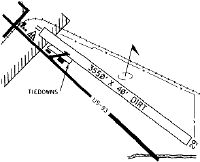
| A110-1 | RWY 12 HAS +35 FT PLINE MKD AT 1600 FT ON CNTRLN. |
| A110-2 | RECOMMEND LAND RY 30; DEPART RY 12, WHEN WINDS PERMIT. |
| A110-3 | FOR CD CTC SALT LAKE ARTCC AT 801-320-2568. |
| A30-H1 | RWY H1 SQUARE HELIPAD LCTD BETWEEN RWY AND PARKING AREA. |
| A34-12/30 | RY 12/30 VERY ROUGH CHIP SEAL. |
| A58-12 | +35 FT PLINE AT 0 FT 115 FT L. |
Runways
Runway Summary
| Runways: | 12/30 H1 |
| Longest Runway: | 12/30 is 4389 ft (1338 m) long |
| Runways with an Instrument Approach: |
U62 Airport Runway Details
| Runway 12/30 | 4389 ft x 60 ft (1338 m x 18 m) | |
| Runway Length Source: | ADO as of 05/02/2007 | |
| Surface: | Asphalt - Fair condition - No special surface treatment | |
Runway 12 |
Runway 30 |
|
Elevation: |
5892.0 | 5863.0 |
Latitude: |
43-54-51.0600N | 43-54-21.0000N |
Longitude: |
113-36-30.1200W | 113-35-46.9200W |
Glide Path Angle: |
0.0 degrees | 0.0 degrees |
Traffic Pattern: |
Left | Left |
Runway Markings Type: |
Basic | Basic |
Runway Markings Condition: |
Fair | Fair |
Object at End: |
PLINE | BRUSH |
Object Height: |
35 | 25 |
Object Marked/Lighted?: |
Marked | |
Distance from End: |
200 | 375 |
Object Centerline Offset: |
115 ft. left of centerline | 0 ft. left and right of centerline |
| Helipad H1 | 50 ft x 50 ft (15 m x 15 m) | |
| Surface: | Asphalt - Fair condition - No special surface treatment | |
Helipad H1 |
||
Glide Path Angle: |
0.0 degrees | 0.0 degrees |
Runway Markings Type: |
None | |
Object Centerline Offset: |
115 ft. left of centerline | 0 ft. left and right of centerline |
Services
Airframe Repair: |
Major |
Powerplant Repair: |
Major |
Bottled Oxygen: |
None |
Bulk Oxygen: |
None |
Fuel Available: |
100LL, MOGAS |
Landing Fees: |
No |
Parking: |
Tiedowns available |
Maps & Diagrams
U62 Sectional
Flight Planning
at skyvector.com
at skyvector.com