Location
Latitude: |
44-38-05.1000N (44.63475) |
Longitude: |
111-20-33.7000W (-111.342694) |
Elevation: |
6596.0 feet MSL (2010 m MSL) |
Magnetic Variation: |
11.3 E (as of April 2024 from WMM2020 model) |
Time Zone: |
UTC -7.0 (Standard Time) UTC -6.0 (Daylight Savings Time) |
From City: |
03 N.M. SE of Island Park, Idaho |
Found On: |
Great Falls Chart |
FAA Region: |
ANM |
Contacts
Manager: |
Publicly owned: |
| DIV ADMIN P.O. BOX 7129 BOISE, ID 83707-1129 208-334-8775 |
STATE OF ID, ITD-DIV OF AERONAUTICS P.O. BOX 7129 BOISE, ID 83707-1129 208-334-8775 |
Operations
Airport Status: |
Operational |
Facility Use: |
Public |
Type: |
Airport |
Activation Date: |
07/1945 |
Control tower: |
No |
Attendance (Months/Days/Hours): |
Months/Days/Hours Unattended |
Boundary ARTCC: |
ZLC (Salt Lake City) |
Responsible ARTCC: |
ZLC (Salt Lake City) |
Segmented Circle Indicator: |
Yes |
Traffic Pattern Altitude (MSL): |
7596 feet (2315 m) |
NOTAMs Facility: |
BOI |
NOTAM-D Service: |
Yes |
Military Landing Rights: |
No |
Civil/Military Joint Use: |
No |
Based Aircraft
Annual Operations (as of 08/30/2023)
| Total Operations: | 1850 | |
| Air Taxi: | 100 | 5.4% |
| GA Itinerant: | 1750 | 94.6% |
Communications
| CTAF: | 122.900 |
Fixed Based Operators (FBOs) & Fuel
(Click on a business for detail)
Please help us keep this information up to date. This is a FREE SERVICE just like everything else on Airport Guide! If you see that a business needs to be added, modified, or deleted please fill out our Update Form.
To add, modify, or delete a business click here.
Please help us keep this information up to date. This is a FREE SERVICE just like everything else on Airport Guide! If you see that a business needs to be added, modified, or deleted please fill out our Update Form.
| Business Name | Frequency | Phone | Fuel Grade |
|---|
Flight Service Stations
| Primary | Alternate | |
| FSS on Field: | N | |
| FSS Name (ID): | Boise(BOI) | |
| Frequency: | ||
| Toll Free Phone: | 1-800-WX-BRIEF |
Instrument Procedures / Charts
Terminal Procedures are only available for airports in several countries with more being added all the time. If you are looking for a specific country's charts, please send an email to support(at)airportguide.com stating the country name. This will be used to prioritize the implementation.
Navigation Aids (Navaids) near U53
| Dist (NM) | ID | Morse Code | Name | Type | Freq | True Hdg | Mag Hdg |
|---|---|---|---|---|---|---|---|
| 7.1 | LO | . _ . . _ _ _ | Targy | NDB | 415 | 119 | 108 |
| 9.5 | WYS | . _ _ _ . _ _ . . . | West Yellowstone | DME | 114.85 | 74 | 63 |
| 10.0 | ESY | . . . . _ . _ _ | Yellowstone | NDB | 338 | 70 | 59 |
| 40.2 | EKS | . _ . _ . . . | Ennis | NDB | 286 | 340 | 329 |
| 49.5 | DBS | _ . . _ . . . . . . | Dubois | VORTAC | 116.90 | 228 | 217 |
| 63.0 | DLN | _ . . . _ . . _ . | Dillon | VOR-DME | 113.00 | 306 | 294 |
| 64.9 | DNW | _ . . _ . . _ _ | Dunoir | VOR-DME | 117.20 | 137 | 126 |
| 66.3 | JAC | . _ _ _ . _ _ . _ . | Jackson | VOR-DME | 115.40 | 156 | 145 |
| 68.0 | ID | . . _ . . | Uconn | NDB | 324 | 204 | 193 |
| 69.4 | BZN | _ . . . _ _ . . _ . | Bozeman | VOR-DME | 112.40 | 6 | 355 |
| 73.8 | IDA | . . _ . . . _ | Idaho Falls | VOR-DME | 113.85 | 205 | 194 |
| 74.3 | BZ | _ . . . _ _ . . | Manni | NDB | 266 | 1 | 350 |
| 74.5 | LVM | . _ . . . . . _ _ _ | Livingston | VOR-DME | 116.10 | 30 | 19 |
| 80.4 | SWU | . . . . _ _ . . _ | Sweden | NDB | 350 | 206 | 195 |
| 81.5 | HIA | . . . . . . . _ | Whitehall | VOR-DME | 113.70 | 334 | 322 |
Nearby Airports with Fuel
Notices to Airmen (NOTAMS)
Remarks
| A110-1 | NO WINTER MAINTENANCE. |
| A110-2 | RECOMMEND LAND RWY 06 TAKEOFF RWY 24 WHEN WIND CONDITIONS ALLOW. |
| A110-3 | LIVESTOCK & BIG GAME ANIMALS HAVE ACCESS TO RY DURING FALL, WINTER & SPRING; DO NOT LEAVE ACFT UNATNDD DURING THESE SEASONS. |
| A110-4 | FOR CD CTC SALT LAKE ARTCC AT 801-320-2568. |
| A110-5 | FST 700 FT OF RWY 6 IS ROUGH DUE TO UNEVEN SFC/BUNCH GRASS AND RODENT ACTIVITY. |
| A42-06 | 06/24 EDGES & THRS MARKED WITH WHITE ROCKS. |
| A52-06 | +4 FT FENCE 20 FT ON CNTRLN. |
| A52-24 | HAS +1200 FT MT 4500 FT ON CNTRLN; +10 FT ROAD 140 FT ON CNTRLN. |
| A57-06 | 4 FT BARB WIRE FENCE SRNDS RWY 6 ON ALL SIDES, 90 FT LEFT & RIGHT, 20 FT ON CNTRLN. |
| A57-24 | 4 FT BARB WIRE FENCE AT 0 FT, 90 FT RIGHT. |
| E111 | ESTABD PRIOR TO 15 MAY 1959. |
Runways
Runway Summary
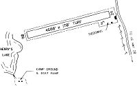
| Runways: | 06/24 |
| Longest Runway: | 06/24 is 4600 ft (1402 m) long |
| Runways with an Instrument Approach: |
U53 Airport Runway Details
| Runway 06/24 | 4600 ft x 170 ft (1402 m x 52 m) | |
| Surface: | Turf - Good condition - No special surface treatment | |
Runway 06 |
Runway 24 |
|
Latitude: |
44-37-59.7600N | 44-38-10.5000N |
Longitude: |
111-21-04.6300W | 111-20-02.8200W |
Glide Path Angle: |
0.0 degrees | 0.0 degrees |
Traffic Pattern: |
Left | Right |
Object at End: |
FENCE | FENCE |
Object Height: |
4 | 4 |
Distance from End: |
0 | 0 |
Object Centerline Offset: |
90 ft. left and right of centerline | 90 ft. right of centerline |
Services
Airframe Repair: |
Major |
Powerplant Repair: |
Major |
Bottled Oxygen: |
None |
Bulk Oxygen: |
High Pressure |
Fuel Available: |
100, 100LL, Jet A, Jet A+ |
Landing Fees: |
Yes |
Parking: |
Hangars and tiedowns available |
Maps & Diagrams
U53 Sectional
Flight Planning
at skyvector.com
at skyvector.com