Location
Latitude: |
29-46-11.3332N (29.769815) |
Longitude: |
094-39-48.5535W (-94.663487) |
Elevation: |
21.2 feet MSL (6 m MSL) |
Magnetic Variation: |
1.4 E (as of April 2024 from WMM2020 model) |
Time Zone: |
UTC -6.0 (Standard Time) UTC -5.0 (Daylight Savings Time) |
From City: |
01 N.M. E of Anahuac, Texas |
Found On: |
Houston Chart |
FAA Region: |
ASW |
Contacts
Manager: |
Publicly owned: |
| RONNIE BROWN PO BOX 938 ANAHUAC, TX 77514 409-267-2719 |
CHAMBERS COUNTY PO BOX 938 ANAHUAC, TX 77514 409-267-2400 |
Operations
Airport Status: |
Operational |
Facility Use: |
Public |
Type: |
Airport |
Activation Date: |
10/1978 |
Control tower: |
No |
Attendance (Months/Days/Hours): |
Months/Days/Hours ALL/MON-FRI/0800-1700 |
Boundary ARTCC: |
ZHU (Houston) |
Responsible ARTCC: |
ZHU (Houston) |
Lighting Schedule: |
SEE RMK |
Segmented Circle Indicator: |
Yes |
Traffic Pattern Altitude (MSL): |
1021 feet (311 m) |
NOTAMs Facility: |
CXO |
NOTAM-D Service: |
Yes |
International Airport of Entry: |
No |
Customs Landing Rights: |
No |
Military Landing Rights: |
Yes |
Civil/Military Joint Use: |
No |
Based Aircraft
| Single Engine: | 8 |
| Multi Engine: | 1 |
| GA Helicopters: | 11 |
Annual Operations (as of 04/04/2023)
| Total Operations: | 2400 | |
| GA Local: | 1600 | 66.7% |
| GA Itinerant: | 800 | 33.3% |
Communications
| CTAF: | 122.900 |
| Approach: | HOUSTON |
| Departure: | HOUSTON |
Fixed Based Operators (FBOs) & Fuel
(Click on a business for detail)
Please help us keep this information up to date. This is a FREE SERVICE just like everything else on Airport Guide! If you see that a business needs to be added, modified, or deleted please fill out our Update Form.
To add, modify, or delete a business click here.
Please help us keep this information up to date. This is a FREE SERVICE just like everything else on Airport Guide! If you see that a business needs to be added, modified, or deleted please fill out our Update Form.
Area Code: 409 |
| Business Name | Frequency | Phone | Fuel Grade |
|---|
Flight Service Stations
| Primary | Alternate | |
| FSS on Field: | N | |
| FSS Name (ID): | Montgomery County(CXO) | |
| Frequency: | ||
| Toll Free Phone: | 1-800-WX-BRIEF |
Instrument Procedures / Charts
FAA Terminal Procedures valid from 0901Z 03/21/24 to 0901Z 04/18/24.
There are various types of charts available for an airport. They are listed in the Page Type column. Here is a legend for those types:
APD - Airport Diagram
DP - Departure Procedure Charts
HOT - Hot Spots
IAP - Instrument Approach Procedure Charts
MIN - Minimums
STAR - Standard Terminal Arrival Charts
| Page Type | Page Name | Volume | Action Since Last Cycle |
|---|---|---|---|
| DP | BLTWY SEVEN (RNAV) | SC-5 | |
| DP | BORRN SIX (RNAV) | SC-5 | |
| DP | BORRN SIX (RNAV)[DELIMITER] CONT.1 | SC-5 | |
| DP | HOODO SEVEN (RNAV) | SC-5 | |
| DP | INDIE EIGHT (RNAV) | SC-5 | |
| DP | KARRR SEVEN (RNAV) | SC-5 | |
| DP | KARRR SEVEN (RNAV)[DELIMITER] CONT.1 | SC-5 | |
| DP | LURIC EIGHT (RNAV) | SC-5 | |
| DP | MMALT SEVEN (RNAV) | SC-5 | |
| DP | PALACIOS THREE | SC-5 | |
| DP | PALACIOS THREE[DELIMITER] CONT.1 | SC-5 | |
| DP | STRYA EIGHT (RNAV) | SC-5 | |
| DP | STYCK EIGHT (RNAV) | SC-5 | |
| DP | WATFO SIX (RNAV) | SC-5 | |
| DP | WYLSN EIGHT (RNAV) | SC-5 | |
| IAP | RNAV (GPS) RWY 12 | SC-5 | |
| MIN | TAKEOFF MINIMUMS | SC-5 | |
| STAR | BLUBELL FOUR | SC-5 | |
| STAR | CESAN FOUR (RNAV) | SC-5 | |
| STAR | CESAN FOUR (RNAV)[DELIMITER] CONT.1 | SC-5 | |
| STAR | HUDZY FOUR | SC-5 | |
| STAR | HUDZY FOUR[DELIMITER] CONT.1 | SC-5 | |
| STAR | OHIIO FOUR | SC-5 | |
| STAR | TKNIQ THREE (RNAV) | SC-5 | |
| STAR | TKNIQ THREE (RNAV)[DELIMITER] CONT.1 | SC-5 | |
| STAR | TSHRT TWO | SC-5 | |
| STAR | TSHRT TWO[DELIMITER] CONT.1 | SC-5 | |
| STAR | WAPPL SIX (RNAV) | SC-5 | |
| STAR | WAPPL SIX (RNAV)[DELIMITER] CONT.1 | SC-5 | |
| STAR | WAPPL SIX (RNAV)[DELIMITER] CONT.2 | SC-5 |
Terminal Procedures are only available for airports in several countries with more being added all the time. If you are looking for a specific country's charts, please send an email to support(at)airportguide.com stating the country name. This will be used to prioritize the implementation.
Navigation Aids (Navaids) near T00
| Dist (NM) | ID | Morse Code | Name | Type | Freq | True Hdg | Mag Hdg |
|---|---|---|---|---|---|---|---|
| 14.1 | MHF | _ _ . . . . . . _ . | Trinity | VOR-DME | 114.75 | 198 | 197 |
| 22.0 | JPA | . _ _ _ . _ _ . . _ | Sanjac | NDB | 347 | 254 | 252 |
| 25.2 | DAS | _ . . . _ . . . | Daisetta | VORTAC | 116.90 | 2 | 1 |
| 26.6 | GLS | _ _ . . _ . . . . . | Galveston | NDB | 206 | 190 | 189 |
| 27.7 | EFD | . . . _ . _ . . | Ellington | TACAN | 109.40 | 249 | 247 |
| 29.7 | GDE | _ _ . _ . . . | Goodhue | NDB | 368 | 52 | 51 |
| 31.7 | BVP | _ . . . . . . _ . _ _ . | Nixin | NDB | 326 | 295 | 293 |
| 31.9 | VUH | . . . _ . . _ . . . . | Scholes | VOR-DME | 113.00 | 199 | 198 |
| 32.7 | HUB | . . . . . . _ _ . . . | Hobby | VOR-DME | 117.10 | 258 | 256 |
| 32.9 | HOU | . . . . _ _ _ . . _ | Houston | VOT | 108.40 | 257 | 255 |
| 33.0 | SBI | . . . _ . . . . . | Sabine Pass | VOR-DME | 115.40 | 98 | 97 |
| 35.3 | BPT | _ . . . . _ _ . _ | Beaumont | VOR-DME | 114.50 | 72 | 71 |
| 37.2 | IAH | . . . _ . . . . | Humble | VORTAC | 116.60 | 287 | 285 |
| 39.9 | HRD | . . . . . _ . _ . . | Hardin County | NDB | 524 | 31 | 30 |
| 48.6 | ORG | _ _ _ . _ . _ _ . | Orange | NDB | 211 | 68 | 67 |
| 51.5 | DWH | _ . . . _ _ . . . . | David Hooks | NDB | 521 | 294 | 292 |
| 51.8 | EYQ | . _ . _ _ _ _ . _ | Weiser | NDB | 286 | 281 | 279 |
| 54.2 | LB | . _ . . _ . . . | Freep | NDB | 263 | 230 | 228 |
| 58.0 | CX | _ . _ . _ . . _ | Alibi | NDB | 281 | 313 | 311 |
| 69.5 | AUR | . _ . . _ . _ . | Sulphur | NDB | 278 | 67 | 66 |
Nearby Airports with Fuel
Notices to Airmen (NOTAMS)
Remarks
| A110-1 | RWY 17/35 SOFT WHEN WET. |
| A110-3 | RWY 17, PAPI RWY 12 IN RWY 17 APCH, DO NOT LAND BFR XNG RWY 12. |
| A110-4 | FOR CD CTC HOUSTON APCH AT 281-443-5844 TO CNL IFR CALL 281-443-5888. |
| A70-FUEL-10 | 0LL FUEL 24 HR SELF-SERVE. |
| A81-APT | DUSK-DAWN. MIRL RWY 12/30 PRESET LOW INTST; TO INCR INTST ACTVT - CTAF. |
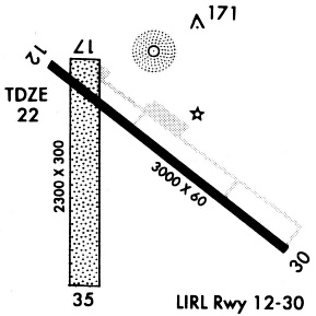
Runways
Runway Summary
| Runways: | 12/30 17/35 |
| Longest Runway: | 12/30 is 3005 ft (916 m) long |
| Runways with an Instrument Approach: |
T00 Airport Runway Details
| Runway 12/30 | 3005 ft x 60 ft (916 m x 18 m) | |
| Runway Length Source: | NGS as of 03/27/1998 | |
| Surface: | Asphalt - Fair condition - No special surface treatment | |
| Runway Edge Lights: | Medium Intensity | |
Runway Weight Bearing Capacity (in thousands of pounds) |
||
| Single Wheel Landing Gear: | 13.0 | |
Runway 12 |
Runway 30 |
|
Elevation: |
20.4 | 20.4 |
Latitude: |
29-46-21.8392N | 29-46-03.2289N |
Longitude: |
094-39-57.9635W | 094-39-31.3658W |
|
Runway True Alignment: |
129 | 309 |
Glide Path Angle: |
4.0 degrees | 0.0 degrees |
Traffic Pattern: |
Left | Right |
Runway Markings Type: |
Nonprecision Instrument | Nonprecision Instrument |
Runway Markings Condition: |
Good | Good |
Object at End: |
POLE | ROAD |
Object Height: |
45 | 15 |
Distance from End: |
882 | 530 |
Object Centerline Offset: |
160 ft. left of centerline | 280 ft. left of centerline |
Visual Glide Slope Indicators: |
2-Light PAPI On Left Side Of Runway | |
Threshold Crossing Height: |
28 |
| Runway 17/35 | 1900 ft x 300 ft (579 m x 91 m) | |
| Runway Length Source: | STATE as of 09/30/2007 | |
| Surface: | Asphalt - Fair condition - No special surface treatment | |
Runway 17 |
Runway 35 |
|
Elevation: |
20.0 | 20.0 |
Latitude: |
29-46-18.8379N | 29-46-00.0300N |
Longitude: |
094-39-54.7040W | 094-39-54.7040W |
|
Runway True Alignment: |
180 | 000 |
Glide Path Angle: |
0.0 degrees | 0.0 degrees |
Traffic Pattern: |
Left | Right |
Runway Markings Type: |
None | None |
Runway Markings Condition: |
Good | Good |
Object at End: |
TREES | ROAD |
Object Height: |
60 | 17 |
Distance from End: |
890 | 230 |
Object Centerline Offset: |
160 ft. left of centerline | 280 ft. left of centerline |
Services
Airframe Repair: |
Minor |
Powerplant Repair: |
Major |
Bottled Oxygen: |
Low Pressure |
Fuel Available: |
100LL, Jet A |
Landing Fees: |
No |
Parking: |
Hangars and tiedowns available |
Maps & Diagrams
T00 Sectional
Flight Planning
at skyvector.com
at skyvector.com