Location
Latitude: |
44-54-34.3000N (44.909528) |
Longitude: |
123-00-09.0000W (-123.0025) |
Elevation: |
213.4 feet MSL (65 m MSL) |
Magnetic Variation: |
14.7 E (as of April 2024 from WMM2020 model) |
Time Zone: |
UTC -8.0 (Standard Time) UTC -7.0 (Daylight Savings Time) |
From City: |
02 N.M. SE of Salem, Oregon |
Found On: |
Seattle Chart |
FAA Region: |
ANM |
Contacts
Manager: |
Publicly owned: |
| JOHN PASKELL 2990 25TH ST SE SALEM, OR 97302 (503) 589-2057 |
CITY OF SALEM 555 LIBERTY ST SE RM 220 SALEM, OR 97301 (503) 588-6255 |
Operations
Airport Status: |
Operational |
Facility Use: |
Public |
Type: |
Airport |
Activation Date: |
11/1937 |
Control tower: |
Yes |
Attendance (Months/Days/Hours): |
Months/Days/Hours ALL/ALL/0730-DUSK |
Boundary ARTCC: |
ZSE (Seattle) |
Responsible ARTCC: |
ZSE (Seattle) |
Lighting Schedule: |
SEE RMK |
Segmented Circle Indicator: |
Yes |
Traffic Pattern Altitude (MSL): |
1213 feet (370 m) |
NOTAMs Facility: |
SLE |
NOTAM-D Service: |
Yes |
International Airport of Entry: |
No |
Customs Landing Rights: |
No |
Military Landing Rights: |
Yes |
Civil/Military Joint Use: |
No |
Aircraft Rescue and Firefighting: |
Class I ARFF Index: B Air Carrier Service: Scheduled Certification Date: 05/1973 |
Based Aircraft
| Single Engine: | 142 |
| Multi Engine: | 9 |
| Jet Engine: | 6 |
| GA Helicopters: | 9 |
| Gliders: | 2 |
| Military Aircraft: | 19 |
Annual Operations (as of 12/31/2022)
| Total Operations: | 45357 | |
| Commercial: | 5 | 0.0% |
| Air Taxi: | 3466 | 7.6% |
| GA Local: | 18086 | 39.9% |
| GA Itinerant: | 20741 | 45.7% |
| Military Aircraft: | 3059 | 6.7% |
Communications
| CTAF: | 119.100 |
| Unicom: | 122.950 |
| Tower: | SALEM 119.1 257.2 Hrs: 0700-2100 |
| Ground: | 121.9 |
| Approach: | SEATTLE ARTCC |
| Departure: | SEATTLE ARTCC |
| ATIS: | 124.55 Hrs: 24 |
| ASOS: | 124.55 (503-371-1062) |
| EMERG: | 121.5 |
| NG OPS: | 142.8 |
| EMERG: | 243.0 |
| NG OPS: | 248.5 |
| NG OPS: | 40.9FM |
- APCH/DEP CTL SVC PRVDD BY SEATTLE ARTCC (ZSE) ON FREQS 125.8/291.7 (HORTON RCAG).
- DUR NML DUTY HR, CTC GUARD OPS, 40.90, 142.8, 248.5 10 MIN OUT.
Fixed Based Operators (FBOs) & Fuel
(Click on a business for detail)
Please help us keep this information up to date. This is a FREE SERVICE just like everything else on Airport Guide! If you see that a business needs to be added, modified, or deleted please fill out our Update Form.
To add, modify, or delete a business click here.
Please help us keep this information up to date. This is a FREE SERVICE just like everything else on Airport Guide! If you see that a business needs to be added, modified, or deleted please fill out our Update Form.
Area Code: 503 |
| Business Name | Frequency | Phone | Fuel Grade |
|---|---|---|---|
| Buswell Aviation, Inc.
Update FBO info |
Unicom 122.95 | 362-9328 | |
| Salem Air Center
Update FBO info |
122.95 | 364-0111 | 80, 100LL, Jet A |
| Salem Executive Flight Center
Update FBO info |
585-3838 | 100LL, Jet A | |
| Val Avionics
Update FBO info |
370-9429 |
Flight Service Stations
| Primary | Alternate | |
| FSS on Field: | N | |
| FSS Name (ID): | Mc Minnville(MMV) | |
| Frequency: | ||
| Toll Free Phone: | 1-800-WX-BRIEF |
Instrument Procedures / Charts
FAA Terminal Procedures valid from 0901Z 03/21/24 to 0901Z 04/18/24.
There are various types of charts available for an airport. They are listed in the Page Type column. Here is a legend for those types:
APD - Airport Diagram
DP - Departure Procedure Charts
HOT - Hot Spots
IAP - Instrument Approach Procedure Charts
MIN - Minimums
STAR - Standard Terminal Arrival Charts
| Page Type | Page Name | Volume | Action Since Last Cycle |
|---|---|---|---|
| APD | AIRPORT DIAGRAM | NW-1 | |
| DP | SALEM FOUR | NW-1 | |
| IAP | ILS OR LOC Z RWY 31 | NW-1 | |
| IAP | LOC BC RWY 13 | NW-1 | |
| IAP | LOC Y RWY 31 | NW-1 | |
| IAP | RNAV (GPS) RWY 13 | NW-1 | |
| IAP | RNAV (GPS) RWY 31 | NW-1 | |
| LAH | LAHSO | NW-1 | |
| MIN | ALTERNATE MINIMUMS | NW-1 | |
| MIN | TAKEOFF MINIMUMS | NW-1 |
Terminal Procedures are only available for airports in several countries with more being added all the time. If you are looking for a specific country's charts, please send an email to support(at)airportguide.com stating the country name. This will be used to prioritize the implementation.
Navigation Aids (Navaids) near SLE
| Dist (NM) | ID | Morse Code | Name | Type | Freq | True Hdg | Mag Hdg |
|---|---|---|---|---|---|---|---|
| 4.3 | SL | . . . . _ . . | Turno | NDB | 266 | 149 | 134 |
| 21.1 | LWG | . _ . . . _ _ _ _ . | Lewisburg | NDB | 225 | 212 | 197 |
| 26.6 | UBG | . . _ _ . . . _ _ . | Newberg | VOR-DME | 117.40 | 2 | 347 |
| 27.6 | CVO | _ . _ . . . . _ _ _ _ | Corvallis | VOR-DME | 115.40 | 206 | 191 |
| 37.9 | HIO | . . . . . . _ _ _ | Hillsboro | VOT | 115.20 | 3 | 348 |
| 42.8 | EU | . . . _ | Frakk | NDB | 260 | 192 | 177 |
| 43.3 | PND | . _ _ . _ . _ . . | Banks | NDB | 356 | 357 | 342 |
| 44.0 | CBU | _ . _ . _ . . . . . _ | Columbia | TACAN | 109.20 | 21 | 6 |
| 44.2 | LBH | . _ . . _ . . . . . . . | Laker | NDB | 332 | 30 | 15 |
| 44.3 | PDX | . _ _ . _ . . _ . . _ | Portland | VOR-DME | 111.80 | 22 | 7 |
| 44.5 | PDX | . _ _ . _ . . _ . . _ | Portland | VOT | 111.00 | 22 | 7 |
| 48.2 | EUG | . . . _ _ _ . | Eugene | VORTAC | 112.90 | 191 | 176 |
| 49.4 | ONP | _ _ _ _ . . _ _ . | Newport | VORTAC | 117.10 | 246 | 231 |
| 53.2 | BTG | _ . . . _ _ _ . | Battle Ground | VORTAC | 116.60 | 18 | 3 |
| 74.9 | LSO | . _ . . . . . _ _ _ | Kelso | NDB | 256 | 2 | 347 |
| 77.8 | PEN | . _ _ . . _ . | Karpen | NDB | 201 | 341 | 326 |
| 82.6 | DSD | _ . . . . . _ . . | Deschutes | VORTAC | 117.60 | 117 | 103 |
| 83.7 | AST | . _ . . . _ | Astoria | VOR-DME | 114.00 | 334 | 319 |
| 87.8 | AST | . _ . . . _ | Fort Stevens | FAN MARKER | 332 | 317 | |
| 92.1 | RD | . _ . _ . . | Bodey | NDB | 411 | 112 | 98 |
Nearby Airports with Fuel
Notices to Airmen (NOTAMS)
Remarks
| A110-10 | ARNG-OPR 1500-0030Z++ MON-FRI EXCP HOL. NO TSNT ALERT SVC. NO PRK. ROTARY WING NOISE ABATEMENT PROC IN EFCT. TSNT ROTARY WING MUST USE SANTIAM ARR/DEP. |
| A110-11 | ARNG-F/W PASSENGER DROP-OFF AND PICKUP POINT FOR LGT ACFT AT VIP PAD ON S END OF MIL RAMP. PPR FOR ALL TSNT ACFT (DSN 355-1401, C971-355-1401). DUR NML DUTY HR, CTC GUARD OPS, 40.90, 142.8, 248.5 10 MIN OUT. KSLE OSA OPS DSN 355-1409, C971-355-1409. |
| A110-12 | FOR CD IF UNA TO CTC ON FSS FREQ, CTC SEATTLE ARTCC AT 253-351-3694. |
| A110-13 | ACFT PRKG ON S G/A RAMP LTD TO ACFT UNDER 12,500 LBS. |
| A110-14 | AIRFIELD CONDS NOT MNTD BTN 1600-0800Z & ALL TIMES SAT & SUN. |
| A110-15 | ARPT CLSD AFT HEAVY SNWFL. |
| A110-3 | BIRD HAZARD: HVY CONCENTRATION WATERFOWL ADJ TO APT & APCHS TO ALL RYS. FLOCKS OF GEESE CONCENTRATED TRANSITING CLASS D AIRSPACE AT TPA OCT-MAY. |
| A110-4 | TWY 'A' FM TWY 'L' TO 'L9' NOT VISIBLE FM ATCT. |
| A110-5 | SELF FUELING, 100LL ONLY, AVBL 24 HRS A DAY. JET A AVBL AFT NML BUS HRS WITH ADVND NOTICE AT 503-508-4178 OR 503-364-4158. |
| A110-7 | PPR RQD FOR PRKG ACFT ON COML RAMP OVR 99,000 LBS CALL AMGR 503-588-6314. |
| A110-8 | NS ABTMT PROCS IN EFCT. AVD OVR FLT OF SRNG RESL AREAS WHEN POSS. |
| A110-9 | RSG TRRN & TREES W & S OF ARPT, INCLG EXTD CNTRLN OF RWY 34. TREES ON EXTD CNTRLN OF RWY 16. NGT OPS NOT RCMD BOTH RWYS. |
| A14 | JPASKELL@CITYOFSALEM.NET |
| A26 | PPR FOR UNSKED ACR OPNS WITH MORE THAN 30 PSGR SEATS CALL AMGR ON 503-588-6314. |
| A75 | OVNGT TIEDOWN FEE & COMMERCIAL AIR CHARTER LDG FEE; HGR AVBL BY PRIOR REQ CALL (503) 364-4158 OR (503) 585-3838. |
| A81-APT | WHEN ATCT CLSD ACTVT MALSR RWY 31; ODALS RWY 13; REILS RWY 13, 16/34; HIRL RWY 13/31; MIRL RWY 16/34 - CTAF. REILS RWY 16 OTS INDEFLY: PAPI RWY 16 & 34 OTS INDEFLY; BCN OTS INDEFLY. |
| E111 | ESTBD PRIOR TO 1959. |
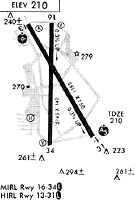
Runways
Runway Summary
| Runways: | 13/31 16/34 H1 |
| Longest Runway: | 13/31 is 5811 ft (1771 m) long |
| Runways with an Instrument Approach: | 31 |
SLE Airport Runway Details
| Runway 13/31 | 5811 ft x 150 ft (1771 m x 46 m) | |
| Runway Length Source: | 3RD PARTY SURVEY as of 10/19/2016 | |
| Surface: | Asphalt - Good condition - Saw-cut or plastic grooved | |
| Runway Pavement Class: | 41 /F/C/X/T | |
| Runway Edge Lights: | High Intensity | |
Runway Weight Bearing Capacity (in thousands of pounds) |
||
| Single Wheel Landing Gear: | 105.0 | |
| Dual Wheel Landing Gear: | 147.0 | |
Runway 13 |
Runway 31 |
|
Elevation: |
194.5 | 213.4 |
Latitude: |
44-55-00.7405N | 44-54-11.0114N |
Longitude: |
123-00-26.1126W | 122-59-45.8523W |
|
Runway True Alignment: |
150 | 330 |
ILS Type: |
ILS/DME | |
Glide Path Angle: |
3.0 degrees | 0.0 degrees |
Traffic Pattern: |
Left | Left |
Runway Markings Type: |
Nonprecision Instrument | Precision Instrument |
Runway Markings Condition: |
Good | Good |
Object at End: |
ROAD | TREE |
Object Height: |
11 | 459 |
Distance from End: |
600 | 15950 |
Object Centerline Offset: |
550 ft. right of centerline | 1900 ft. left of centerline |
Visual Glide Slope Indicators: |
4-Box VASI On Left Side Of Runway | |
Runway Visual Range (RVR): |
Rollout | Touchdown |
Approach Light System: |
Omnidirectional Approach Lighting System | 1,400 Foot Medium Intensity Approach Lighting System With Runway Alignment Indicator Lights |
REIL: |
Yes | |
Threshold Crossing Height: |
50 | |
Declared Distances |
||
Take Off Run Avbl. (TORA): |
5811 | 5811 |
Take Off Distance Avbl. (TODA): |
5811 | 5811 |
Actual Stop Dist. Avbl. (ASDA): |
5811 | 5811 |
Landing Dist. Avbl. (LDA): |
5811 | 5811 |
| Runway 16/34 | 5146 ft x 100 ft (1569 m x 30 m) | |
| Runway Length Source: | 3RD PARTY SURVEY as of 10/19/2016 | |
| Surface: | Asphalt - Good condition - Saw-cut or plastic grooved | |
| Runway Pavement Class: | 15 /F/D/X/T | |
| Runway Edge Lights: | Medium Intensity | |
Runway Weight Bearing Capacity (in thousands of pounds) |
||
| Single Wheel Landing Gear: | 39.5 | |
| Dual Wheel Landing Gear: | 52.0 | |
Runway 16 |
Runway 34 |
|
Elevation: |
195.7 | 210.9 |
Latitude: |
44-54-58.0017N | 44-54-07.1975N |
Longitude: |
123-00-11.8900W | 123-00-12.8554W |
|
Runway True Alignment: |
181 | 001 |
Glide Path Angle: |
3.0 degrees | 4.0 degrees |
Traffic Pattern: |
Left | Left |
Runway Markings Type: |
Nonprecision Instrument | Nonprecision Instrument |
Runway Markings Condition: |
Good | Good |
Object at End: |
ROAD | TREE |
Object Height: |
16 | 216 |
Distance from End: |
430 | 4528 |
Object Centerline Offset: |
550 ft. right of centerline | 1900 ft. left of centerline |
Visual Glide Slope Indicators: |
4-Light PAPI On Left Side Of Runway | 4-Light PAPI On Left Side Of Runway |
REIL: |
Yes | Yes |
Threshold Crossing Height: |
38 | 42 |
Declared Distances |
||
Take Off Run Avbl. (TORA): |
5145 | 5145 |
Take Off Distance Avbl. (TODA): |
5145 | 5145 |
Actual Stop Dist. Avbl. (ASDA): |
5145 | 5145 |
Landing Dist. Avbl. (LDA): |
5145 | 5145 |
| Helipad H1 | 37 ft x 37 ft (11 m x 11 m) | |
| Runway Length Source: | FAA OE/AAA as of 10/25/2018 | |
| Surface: | Asphalt - Good condition - No special surface treatment | |
Helipad H1 |
||
Elevation: |
213.4 | |
Latitude: |
44-54-26.6300N | |
Longitude: |
122-59-45.2600W | |
Glide Path Angle: |
0.0 degrees | 0.0 degrees |
Runway Markings Type: |
Basic | |
Runway Markings Condition: |
Good | |
Object Centerline Offset: |
550 ft. right of centerline | 1900 ft. left of centerline |
Services
Airframe Repair: |
None |
Powerplant Repair: |
None |
Bottled Oxygen: |
None |
Bulk Oxygen: |
None |
Fuel Available: |
100, MOGAS |
Landing Fees: |
No |
Parking: |
Tiedowns available |
Maps & Diagrams
SLE Sectional
Flight Planning
at skyvector.com
at skyvector.com