Location
Latitude: |
47-47-34.7970N (47.792999) |
Longitude: |
103-14-57.6680W (-103.249352) |
Elevation: |
2135.1 feet MSL (651 m MSL) |
Magnetic Variation: |
7.3 E (as of April 2024 from WMM2020 model) |
Time Zone: |
UTC -6.0 (Standard Time) UTC -5.0 (Daylight Savings Time) |
From City: |
01 N.M. ESE of Watford City, North Dakota |
Found On: |
Billings Chart |
FAA Region: |
AGL |
Contacts
Manager: |
Publicly owned: |
| LUKE TAYLOR BOX 730 WATFORD CITY, ND 58854 (701) 570-2646 |
WATFORD CITY ARPT AUTH BOX 730 WATFORD CITY, ND 58854 (701) 570-2646 |
Operations
Airport Status: |
Operational |
Facility Use: |
Public |
Type: |
Airport |
Control tower: |
No |
Attendance (Months/Days/Hours): |
Months/Days/Hours ALL/MON-FRI/0800-1700 |
Boundary ARTCC: |
ZLC (Salt Lake City) |
Responsible ARTCC: |
ZLC (Salt Lake City) |
Lighting Schedule: |
SEE RMK |
Segmented Circle Indicator: |
Yes |
Traffic Pattern Altitude (MSL): |
3135 feet (956 m) |
NOTAMs Facility: |
GFK |
NOTAM-D Service: |
Yes |
International Airport of Entry: |
No |
Customs Landing Rights: |
No |
Military Landing Rights: |
Yes |
Civil/Military Joint Use: |
No |
Based Aircraft
| Single Engine: | 30 |
| Multi Engine: | 3 |
| Jet Engine: | 2 |
Annual Operations (as of 10/14/2016)
| Total Operations: | 7300 | |
| Air Taxi: | 750 | 10.3% |
| GA Local: | 3500 | 47.9% |
| GA Itinerant: | 3000 | 41.1% |
| Military Aircraft: | 50 | 0.7% |
Communications
| CTAF: | 122.800 |
| Unicom: | 122.800 |
| AWOS-3PT: | 118.125 (701-842-4855) |
- APCH/DEP CTL SVC PRVDD BY SALT LAKE CITY ARTCC ( ZLC) ON FREQS 126.85/305.2 (GLASGOW RCAG).
Fixed Based Operators (FBOs) & Fuel
(Click on a business for detail)
Please help us keep this information up to date. This is a FREE SERVICE just like everything else on Airport Guide! If you see that a business needs to be added, modified, or deleted please fill out our Update Form.
To add, modify, or delete a business click here.
Please help us keep this information up to date. This is a FREE SERVICE just like everything else on Airport Guide! If you see that a business needs to be added, modified, or deleted please fill out our Update Form.
Area Code: 701 |
| Business Name | Frequency | Phone | Fuel Grade |
|---|
Flight Service Stations
| Primary | Alternate | |
| FSS on Field: | N | |
| FSS Name (ID): | Grand Forks(GFK) | |
| Frequency: | ||
| Toll Free Phone: | 1-800-WX-BRIEF |
Instrument Procedures / Charts
FAA Terminal Procedures valid from 0901Z 03/21/24 to 0901Z 04/18/24.
There are various types of charts available for an airport. They are listed in the Page Type column. Here is a legend for those types:
APD - Airport Diagram
DP - Departure Procedure Charts
HOT - Hot Spots
IAP - Instrument Approach Procedure Charts
MIN - Minimums
STAR - Standard Terminal Arrival Charts
| Page Type | Page Name | Volume | Action Since Last Cycle |
|---|---|---|---|
| IAP | RNAV (GPS) RWY 12 | NC-1 | |
| IAP | RNAV (GPS) RWY 30 | NC-1 | |
| MIN | ALTERNATE MINIMUMS | NC-1 | |
| MIN | TAKEOFF MINIMUMS | NC-1 |
Terminal Procedures are only available for airports in several countries with more being added all the time. If you are looking for a specific country's charts, please send an email to support(at)airportguide.com stating the country name. This will be used to prioritize the implementation.
Navigation Aids (Navaids) near S25
| Dist (NM) | ID | Morse Code | Name | Type | Freq | True Hdg | Mag Hdg |
|---|---|---|---|---|---|---|---|
| 22.2 | SF | . . . . . _ . | Yuson | NDB | 275 | 331 | 324 |
| 25.1 | ISN | . . . . . _ . | Williston | NDB | 275 | 327 | 320 |
| 34.2 | ISN | . . . . . _ . | Williston | VOR-DME | 116.30 | 324 | 317 |
| 37.9 | SDY | . . . _ . . _ . _ _ | Sidney | NDB | 359 | 262 | 254 |
| 59.2 | DIK | _ . . . . _ . _ | Dickinson | VORTAC | 112.90 | 160 | 153 |
| 69.8 | DI | _ . . . . | Noson | NDB | 353 | 161 | 154 |
| 74.5 | GDV | _ _ . _ . . . . . _ | Glendive | NDB | 410 | 238 | 230 |
| 74.5 | GDV | _ _ . _ . . . . . _ | Glendive | DME | 114.35 | 238 | 230 |
| 78.6 | PWD | . _ _ . . _ _ _ . . | Plentywood | NDB | 251 | 319 | 311 |
| 83.6 | MOT | _ _ _ _ _ _ | Minot | VOR-DME | 117.10 | 69 | 62 |
| 84.2 | MIB | _ _ . . _ . . . | Deering | TACAN | 114.90 | 62 | 55 |
| 86.4 | L7 | Estevan | NDB | 395 | 10 | 3 | |
| 96.0 | BKU | _ . . . _ . _ . . _ | Timber | NDB | 344 | 205 | 197 |
| 96.3 | CRR | _ . _ . . _ . . _ . | Circle | NDB | 245 | 257 | 249 |
| 96.4 | OLF | _ _ _ . _ . . . . _ . | Wolf Point | NDB | 404 | 282 | 274 |
| 96.8 | BOD | _ . . . _ _ _ _ . . | Bowman | NDB | 374 | 184 | 177 |
Nearby Airports with Fuel
Notices to Airmen (NOTAMS)
Remarks
| A110-1 | AFT WINTER STORMS CFM ARPT CONDS WITH AMGR; CALL (701) 300-3045 OR 701-570-2646. |
| A110-2 | DEER & ANTELOPE ON OR INVOF ARPT. |
| A110-3 | FOR CD CTC SALT LAKE ARTCC AT 801-320-2568. |
| A16 | ADDNL CONTACT - FBO PHONE 701-300-3045. |
| A17 | ON CALL WEEKENDS AND NIGHTS |
| A52-12 | ALSO +306 FT TWR 6600 FT FROM THR 4000 FT RIGHT OF CNTRLN EXTDD. |
| A53-30 | +167'HILL LGTD W/OBS LGTS. |
| A70-FUEL-A | FULL SVC FUEL AVBL 800-1700 M-F AND SELF SVC WITH CREDIT CARD ALL OTHER HOURS. |
| A76 | FOR AGRI SVC CALL 701-570-2646. |
| A81-APT | ACTVT PAPI RWY 12 & 30 - CTAF. MIRL RWY 12/30 PRESET ON LOW INTST DUSK-DAWN, TO INCR INTST - CTAF. |
| A82 | UNICOM LCTD AT SHERIFF'S OFFICE. |
Runways
Runway Summary
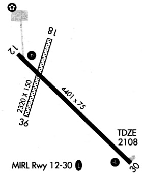
| Runways: | 12/30 |
| Longest Runway: | 12/30 is 6550 ft (1996 m) long |
| Runways with an Instrument Approach: |
S25 Airport Runway Details
| Runway 12/30 | 6550 ft x 75 ft (1996 m x 23 m) | |
| Runway Length Source: | 3RD PARTY SURVEY as of 10/25/2021 | |
| Surface: | Concrete - Excellent condition - Saw-cut or plastic grooved | |
| Runway Pavement Class: | 28 /R/B/W/T | |
| Runway Edge Lights: | Medium Intensity | |
Runway Weight Bearing Capacity (in thousands of pounds) |
||
| Single Wheel Landing Gear: | 78.0 | |
| Dual Wheel Landing Gear: | 98.0 | |
| Dual Tandem Wheel Landing Gear: | 186.0 | |
Runway 12 |
Runway 30 |
|
Elevation: |
2063.1 | 2135.0 |
Latitude: |
47-47-52.2707N | 47-47-17.3196N |
Longitude: |
103-15-38.0217W | 103-14-17.3210W |
|
Runway True Alignment: |
123 | 303 |
Glide Path Angle: |
3.0 degrees | 3.0 degrees |
Traffic Pattern: |
Left | Left |
Runway Markings Type: |
Nonprecision Instrument | Nonprecision Instrument |
Runway Markings Condition: |
Good | Good |
Object at End: |
ROAD | ROAD |
Object Height: |
16 | 16 |
Object Marked/Lighted?: |
Lighted | |
Distance from End: |
240 | 550 |
Object Centerline Offset: |
250 ft. right of centerline | 300 ft. left of centerline |
Visual Glide Slope Indicators: |
2-Light PAPI On Left Side Of Runway | 2-Light PAPI On Left Side Of Runway |
Threshold Crossing Height: |
43 | 45 |
Threshold Elevation: |
2068.5 | 2131.1 |
Displaced Threshold: |
1023 | 750 |
Threshold Latitude: |
47-47-46.8133N | 47-47-21.3219N |
Threshold Longitude: |
103-15-25.4194W | 103-14-26.5609W |
Declared Distances |
||
Take Off Run Avbl. (TORA): |
5800 | 5500 |
Take Off Distance Avbl. (TODA): |
5800 | 5500 |
Actual Stop Dist. Avbl. (ASDA): |
6550 | 6400 |
Landing Dist. Avbl. (LDA): |
5500 | 5650 |
Services
Airframe Repair: |
Major |
Powerplant Repair: |
Major |
Bottled Oxygen: |
None |
Bulk Oxygen: |
None |
Fuel Available: |
100LL |
Landing Fees: |
No |
Parking: |
Hangars and tiedowns available |
Maps & Diagrams
S25 Sectional
Flight Planning
at skyvector.com
at skyvector.com