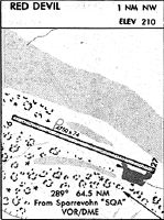
Location
Latitude: |
61-47-17.0000N (61.788056) |
Longitude: |
157-21-00.9000W (-157.35025) |
Elevation: |
180.6 feet MSL (55 m MSL) |
Magnetic Variation: |
11.8 E (as of April 2024 from WMM2020 model) |
Time Zone: |
UTC -9.0 (Standard Time) UTC -8.0 (Daylight Savings Time) |
From City: |
01 N.M. NW of Red Devil, Alaska |
Found On: |
Mc Grath Chart |
FAA Region: |
AAL |
Contacts
Manager: |
Publicly owned: |
| ROXANNE EVAN PO BOX 584 ANIAK, AK 99557 907-675-4345 |
ALASKA DOT&PF CENTRAL REGION PO BOX 196900 ANCHORAGE, AK 99519-6900 907-269-0749 |
Operations
Airport Status: |
Operational |
Facility Use: |
Public |
Type: |
Airport |
Activation Date: |
11/1954 |
Control tower: |
No |
Attendance (Months/Days/Hours): |
Months/Days/Hours Unattended |
Boundary ARTCC: |
ZAN (Anchorage) |
Responsible ARTCC: |
ZAN (Anchorage) |
Segmented Circle Indicator: |
No |
Traffic Pattern Altitude (MSL): |
1181 feet (360 m) |
NOTAMs Facility: |
ENA |
NOTAM-D Service: |
Yes |
International Airport of Entry: |
No |
Customs Landing Rights: |
No |
Military Landing Rights: |
Yes |
Civil/Military Joint Use: |
No |
Based Aircraft
Annual Operations (as of 12/31/2022)
| Total Operations: | 500 | |
| Air Taxi: | 500 | 100.0% |
Communications
| CTAF: | 122.800 |
Fixed Based Operators (FBOs) & Fuel
(Click on a business for detail)
Please help us keep this information up to date. This is a FREE SERVICE just like everything else on Airport Guide! If you see that a business needs to be added, modified, or deleted please fill out our Update Form.
To add, modify, or delete a business click here.
Please help us keep this information up to date. This is a FREE SERVICE just like everything else on Airport Guide! If you see that a business needs to be added, modified, or deleted please fill out our Update Form.
Area Code: 907 |
| Business Name | Frequency | Phone | Fuel Grade |
|---|
Flight Service Stations
| Primary | Alternate | |
| FSS on Field: | N | |
| FSS Name (ID): | Kenai(ENA) | |
| Frequency: | ||
| Toll Free Phone: | 1-866-864-1737 |
Instrument Procedures / Charts
Terminal Procedures are only available for airports in several countries with more being added all the time. If you are looking for a specific country's charts, please send an email to support(at)airportguide.com stating the country name. This will be used to prioritize the implementation.
Navigation Aids (Navaids) near RDV
| Dist (NM) | ID | Morse Code | Name | Type | Freq | True Hdg | Mag Hdg |
|---|---|---|---|---|---|---|---|
| 64.3 | SQA | . . . _ _ . _ . _ | Sparrevohn | VOR-DME | 117.20 | 129 | 117 |
| 65.0 | ANI | . _ _ . . . | Aniak | NDB | 359 | 260 | 249 |
| 65.6 | CRN | _ . _ . . _ . _ . | Cairn Mountain | NDB | 281 | 128 | 116 |
| 84.9 | MCG | _ _ _ . _ . _ _ . | Mc Grath | VORTAC | 115.50 | 33 | 21 |
| 85.6 | VTR | . . . _ _ . _ . | Takotna River | NDB | 350 | 34 | 22 |
| 94.4 | ANV | . _ _ . . . . _ | Anvik | NDB | 365 | 304 | 293 |
Nearby Airports with Fuel
| Dist (NM) | Name (Airport IDs) | True Hdg | Mag Hdg | Fuel Grade |
|---|---|---|---|---|
| 22.9 | Crooked Creek Airport (CKD CJX) |
282 | 271 | MOGAS |
| 63.7 | Aniak Airport (ANI PANI ANI) |
259 | 248 | 100LL, Jet A |
| 85.1 | Mc Grath Airport (MCG PAMC MCG) |
33 | 21 | 100LL, Jet A-1+ |
Notices to Airmen (NOTAMS)
Remarks
| A110-1 | RY CONDITION NOT MONITORED; RECOMMEND VISUAL INSPECTION PRIOR TO USING. |
| A110-6 | NIGHT OPERATIONS PROHIBITED, EXCEPT ROTARY WING. |
| A110-7 | SLEETMUTE AIRSTRIP EIGHT MILES SE. |
| A110-8 | LARGE WILDLIFE AND BIRDS ON RY OR INVOF ARPT. |
| A33-10/28 | PART OF THE RY IS WASHBOARDED AND ROUGH WITH 3 INCH RIDGES AND 2 INCH DEPRESSIONS. |
| A42-10 | RY 10/28 THLD MARKED BY 30 INCH TALL ORANGE CONES WITH REFLECTIVE COLLARS. |
Runways
Runway Summary
| Runways: | 10/28 |
| Longest Runway: | 10/28 is 4820 ft (1469 m) long |
| Runways with an Instrument Approach: |
RDV Airport Runway Details
| Runway 10/28 | 4820 ft x 75 ft (1469 m x 23 m) | |
| Runway Length Source: | 3RD PARTY SURVEY as of 09/03/2010 | |
| Surface: | Gravel - Fair condition - No special surface treatment | |
Runway 10 |
Runway 28 |
|
Elevation: |
179.5 | 180.5 |
Latitude: |
61-47-29.1991N | 61-47-04.8717N |
Longitude: |
157-21-43.9752W | 157-20-17.9073W |
|
Runway True Alignment: |
121 | 301 |
Glide Path Angle: |
0.0 degrees | 0.0 degrees |
Traffic Pattern: |
Left | Left |
Object at End: |
TREES | ROAD |
Object Height: |
25 | 15 |
Distance from End: |
0 | 0 |
Object Centerline Offset: |
120 ft. left and right of centerline | 50 ft. right of centerline |
Services
Airframe Repair: |
Minor |
Powerplant Repair: |
Minor |
Fuel Available: |
100LL, Jet A-1+ |
Landing Fees: |
No |
Parking: |
Hangars and tiedowns available |
Maps & Diagrams
RDV Sectional
Flight Planning
at skyvector.com
at skyvector.com