Location
Latitude: |
29-42-34.3670N (29.709546) |
Longitude: |
091-20-20.3230W (-91.338979) |
Elevation: |
8.5 feet MSL (3 m MSL) |
Magnetic Variation: |
0.6 W (as of April 2024 from WMM2020 model) |
Time Zone: |
UTC -6.0 (Standard Time) UTC -5.0 (Daylight Savings Time) |
From City: |
02 N.M. NW of Patterson, Louisiana |
Found On: |
Houston Chart |
FAA Region: |
ASW |
Contacts
Manager: |
Publicly owned: |
| MR. JEAN PAUL BOURG 500 MAIN ST, 5TH FLOOR COURTHOUSE FRANKLIN, LA 70538 337-828-4100 |
STATE OF LOUISIANA DOTD AVIATION SECTION, PO BOX 94245 BATON ROUGE, LA 70804 225-379-3950 |
Operations
Airport Status: |
Operational |
Facility Use: |
Public |
Type: |
Airport |
Activation Date: |
04/1940 |
Control tower: |
No |
Attendance (Months/Days/Hours): |
Months/Days/Hours ALL/ALL/ALL |
Boundary ARTCC: |
ZHU (Houston) |
Responsible ARTCC: |
ZHU (Houston) |
Lighting Schedule: |
SEE RMK |
Segmented Circle Indicator: |
No |
Traffic Pattern Altitude (MSL): |
1008 feet (307 m) |
NOTAMs Facility: |
PTN |
NOTAM-D Service: |
Yes |
International Airport of Entry: |
No |
Customs Landing Rights: |
Yes |
Military Landing Rights: |
Yes |
Civil/Military Joint Use: |
No |
Based Aircraft
| Single Engine: | 13 |
| Multi Engine: | 2 |
| Jet Engine: | 1 |
| GA Helicopters: | 6 |
Annual Operations (as of 08/11/2020)
| Total Operations: | 45075 | |
| GA Local: | 22000 | 48.8% |
| GA Itinerant: | 23000 | 51.0% |
| Military Aircraft: | 75 | 0.2% |
Communications
| CTAF: | 122.800 |
| Unicom: | 122.800 |
| Approach: | NEW ORLEANS 124.3 124.3 124.3 |
| Departure: | NEW ORLEANS 124.3 124.3 124.3 |
| AWOS-3PT: | 134.575 (985-395-6735) |
Fixed Based Operators (FBOs) & Fuel
(Click on a business for detail)
Please help us keep this information up to date. This is a FREE SERVICE just like everything else on Airport Guide! If you see that a business needs to be added, modified, or deleted please fill out our Update Form.
To add, modify, or delete a business click here.
Please help us keep this information up to date. This is a FREE SERVICE just like everything else on Airport Guide! If you see that a business needs to be added, modified, or deleted please fill out our Update Form.
Area Code: 318 |
| Business Name | Frequency | Phone | Fuel Grade |
|---|---|---|---|
| Perry Flying Center, Inc.
Update FBO info |
Unicom 122.8 | 395-4501, 395-4502 | 100LL, Jet A, MOGAS |
Flight Service Stations
| Primary | Alternate | |
| FSS on Field: | N | |
| FSS Name (ID): | De Ridder(DRI) | |
| Frequency: | ||
| Toll Free Phone: | 1-800-WX-BRIEF |
Instrument Procedures / Charts
FAA Terminal Procedures valid from 0901Z 03/21/24 to 0901Z 04/18/24.
There are various types of charts available for an airport. They are listed in the Page Type column. Here is a legend for those types:
APD - Airport Diagram
DP - Departure Procedure Charts
HOT - Hot Spots
IAP - Instrument Approach Procedure Charts
MIN - Minimums
STAR - Standard Terminal Arrival Charts
| Page Type | Page Name | Volume | Action Since Last Cycle |
|---|---|---|---|
| IAP | ILS OR LOC RWY 24 | SC-4 | |
| IAP | RNAV (GPS) RWY 06 | SC-4 | |
| IAP | RNAV (GPS) RWY 24 | SC-4 | |
| MIN | ALTERNATE MINIMUMS | SC-4 | |
| MIN | TAKEOFF MINIMUMS | SC-4 |
Terminal Procedures are only available for airports in several countries with more being added all the time. If you are looking for a specific country's charts, please send an email to support(at)airportguide.com stating the country name. This will be used to prioritize the implementation.
Navigation Aids (Navaids) near PTN
| Dist (NM) | ID | Morse Code | Name | Type | Freq | True Hdg | Mag Hdg |
|---|---|---|---|---|---|---|---|
| 0.3 | PTN | . _ _ . _ _ . | Patterson | NDB | 245 | 21 | 22 |
| 26.7 | TBD | _ _ . . . _ . . | Tibby | VOR-DME | 112.00 | 95 | 96 |
| 31.0 | AR | . _ . _ . | Acadi | NDB | 269 | 298 | 298 |
| 44.7 | LFT | . _ . . . . _ . _ | Lafayette | VORTAC | 109.80 | 310 | 310 |
| 45.1 | RQR | . _ . _ _ . _ . _ . | Reserve | VOR-DME | 110.80 | 59 | 60 |
| 45.6 | LF | . _ . . . . _ . | Laffs | NDB | 375 | 319 | 319 |
| 45.9 | BNZ | _ . . . _ . _ _ . . | Abbeville | NDB | 230 | 297 | 297 |
| 46.6 | LSU | . _ . . . . . . . _ | Fighting Tiger | VORTAC | 116.50 | 2 | 3 |
| 52.4 | MS | _ _ . . . | Kinte | NDB | 338 | 68 | 69 |
| 52.8 | BT | _ . . . _ | Rundi | NDB | 284 | 7 | 8 |
| 54.0 | LLA | . _ . . . _ . . . _ | White Lake | VOR-DME | 114.95 | 267 | 267 |
| 56.0 | FWX | . . _ . . _ _ _ . . _ | New Roads | NDB | 356 | 352 | 353 |
| 68.2 | HMU | . . . . _ _ . . _ | Hammond | VOR | 109.60 | 44 | 45 |
| 69.1 | OPL | _ _ _ . _ _ . . _ . . | St Landry | NDB | 335 | 325 | 325 |
| 70.1 | HRV | . . . . . _ . . . . _ | Harvey | VORTAC | 114.10 | 82 | 83 |
| 71.9 | HP | . . . . . _ _ . | Anger | NDB | 212 | 41 | 42 |
| 72.1 | LEV | . _ . . . . . . _ | Leeville | VORTAC | 113.50 | 116 | 117 |
| 76.9 | ECY | . _ . _ . _ . _ _ | Duralde | NDB | 263 | 311 | 311 |
| 83.4 | BWK | _ . . . . _ _ _ . _ | Bunkie | NDB | 397 | 326 | 326 |
| 89.6 | LRR | . _ . . . _ . . _ . | Oakdale | NDB | 379 | 308 | 308 |
Nearby Airports with Fuel
Notices to Airmen (NOTAMS)
Remarks
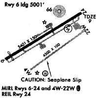
| A110-2 | 4500 FT BY 100 FT WATERWAY HDG 04/22 LCTD 1100 FT SOUTH OF CONC RWY. DUAL LAND/SEA OPERATION. |
| A110-3 | FOR CD CTC NEW ORLEANS APCH AT 504-471-4350 OR 124.3. |
| A57-06 | APCH RATIO 23:1 TO DTHR. |
| A81-APT | ACTVT MALSR RWY 24; MIRL RWY 06/24 PRESET MED INTST, TO INCR INTST - CTAF. |
Runways
Runway Summary
| Runways: | 04W/22W 06/24 |
| Longest Runway: | 06/24 is 5399 ft (1646 m) long |
| Runways with an Instrument Approach: | 24 |
PTN Airport Runway Details
| Runway 04W/22W | 4500 ft x 100 ft (1372 m x 30 m) | |
| Surface: | Water - Good condition - No special surface treatment | |
Runway 04W |
Runway 22W |
|
Elevation: |
1.0 | 1.0 |
Latitude: |
29-42-15.9100N | 29-42-41.7400N |
Longitude: |
091-20-37.9100W | 091-19-56.3830W |
|
Runway True Alignment: |
055 | 235 |
Glide Path Angle: |
0.0 degrees | 0.0 degrees |
Traffic Pattern: |
Right | Left |
Object at End: |
ROAD | |
Object Height: |
20 | |
Distance from End: |
600 | |
Object Centerline Offset: |
0 ft. left and right of centerline |
| Runway 06/24 | 5399 ft x 150 ft (1646 m x 46 m) | |
| Runway Length Source: | NGS as of 12/13/2000 | |
| Surface: | Water - Good condition - No special surface treatment | |
| Runway Edge Lights: | Medium Intensity | |
Runway Weight Bearing Capacity (in thousands of pounds) |
||
| Single Wheel Landing Gear: | 32.0 | |
Runway 06 |
Runway 24 |
|
Elevation: |
6.7 | 8.4 |
Latitude: |
29-42-25.2262N | 29-42-52.6667N |
Longitude: |
091-20-49.2318W | 091-19-56.6989W |
|
Runway True Alignment: |
059 | 239 |
ILS Type: |
ILS/DME | |
Glide Path Angle: |
3.0 degrees | 3.0 degrees |
Traffic Pattern: |
Left | Right |
Runway Markings Type: |
Nonprecision Instrument | Precision Instrument |
Runway Markings Condition: |
Fair | Fair |
Object at End: |
TREES | |
Object Height: |
58 | |
Distance from End: |
1491 | |
Object Centerline Offset: |
0 ft. left and right of centerline | |
Visual Glide Slope Indicators: |
2-Light PAPI On Left Side Of Runway | 2-Light PAPI On Left Side Of Runway |
Approach Light System: |
1,400 Foot Medium Intensity Approach Lighting System With Runway Alignment Indicator Lights | |
REIL: |
Yes | No |
Threshold Crossing Height: |
50 | 50 |
Threshold Elevation: |
7.3 | |
Displaced Threshold: |
394 | |
Threshold Latitude: |
29-42-27.2310N | |
Threshold Longitude: |
091-20-45.3944W |
Services
Airframe Repair: |
None |
Powerplant Repair: |
None |
Bottled Oxygen: |
None |
Bulk Oxygen: |
None |
Fuel Available: |
100LL |
Landing Fees: |
No |
Parking: |
Tiedowns available |
Maps & Diagrams
PTN Sectional
Flight Planning
at skyvector.com
at skyvector.com