Location
Latitude: |
39-51-32.4060N (39.859002) |
Longitude: |
075-17-58.6710W (-75.299631) |
Elevation: |
0.0 feet MSL (0 m MSL) |
Magnetic Variation: |
11.8 W (as of April 2024 from WMM2020 model) |
Time Zone: |
UTC -5.0 (Standard Time) UTC -4.0 (Daylight Savings Time) |
From City: |
01 N.M. S of Essington, Pennsylvania |
Found On: |
Washington Chart |
FAA Region: |
AEA |
Contacts
Manager: |
Publicly owned: |
| DAVID SCHREIBER 97 WANNAMAKER AVE ESSINGTON, PA 19029 610-521-3530 |
TOWNSHIP OF TINICUM 629 N GOVERNOR PRINTZ BLVD ESSINGTON, PA 19029 610-521-3530 |
Operations
Airport Status: |
Operational |
Facility Use: |
Public |
Type: |
Seaplane Base |
Activation Date: |
02/1946 |
Control tower: |
No |
Attendance (Months/Days/Hours): |
Months/Days/Hours UNATTENDED |
Boundary ARTCC: |
ZDC (Washington) |
Responsible ARTCC: |
ZNY (New York) |
Segmented Circle Indicator: |
No |
Traffic Pattern Altitude (MSL): |
1000 feet (305 m) |
NOTAMs Facility: |
IPT |
NOTAM-D Service: |
Yes |
Based Aircraft
Annual Operations (as of 05/31/2022)
| Total Operations: | 12 | |
| GA Itinerant: | 12 | 100.0% |
Communications
| CTAF: | 122.900 |
Fixed Based Operators (FBOs) & Fuel
(Click on a business for detail)
Please help us keep this information up to date. This is a FREE SERVICE just like everything else on Airport Guide! If you see that a business needs to be added, modified, or deleted please fill out our Update Form.
To add, modify, or delete a business click here.
Please help us keep this information up to date. This is a FREE SERVICE just like everything else on Airport Guide! If you see that a business needs to be added, modified, or deleted please fill out our Update Form.
Area Code: 610 |
| Business Name | Frequency | Phone | Fuel Grade |
|---|---|---|---|
| Philadelphia SPB
Update FBO info |
521-3633 | 80 |
Flight Service Stations
| Primary | Alternate | |
| FSS on Field: | N | |
| FSS Name (ID): | Williamsport(IPT) | |
| Frequency: | ||
| Toll Free Phone: | 1-800-WX-BRIEF |
Instrument Procedures / Charts
Terminal Procedures are only available for airports in several countries with more being added all the time. If you are looking for a specific country's charts, please send an email to support(at)airportguide.com stating the country name. This will be used to prioritize the implementation.
Navigation Aids (Navaids) near PSQ
| Dist (NM) | ID | Morse Code | Name | Type | Freq | True Hdg | Mag Hdg |
|---|---|---|---|---|---|---|---|
| 3.1 | PHL | . _ _ . . . . . . _ . . | Philadelphia | VOT | 109.80 | 82 | 94 |
| 13.4 | OOD | _ _ _ _ _ _ _ . . | Woodstown | VORTAC | 112.80 | 180 | 192 |
| 16.0 | ING | . . _ . _ _ . | Ambler | NDB | 275 | 2 | 14 |
| 17.5 | MXE | _ _ _ . . _ . | Modena | VORTAC | 113.20 | 281 | 293 |
| 17.9 | DQO | _ . . _ _ . _ _ _ _ | Dupont | VORTAC | 114.00 | 232 | 244 |
| 18.9 | PNE | . _ _ . _ . . | North Philadelphia | VOR | 112.00 | 44 | 56 |
| 22.1 | IL | . . . _ . . | Hadin | NDB | 248 | 221 | 233 |
| 24.6 | VCN | . . . _ _ . _ . _ . | Cedar Lake | VOR-DME | 115.20 | 141 | 153 |
| 24.9 | PTW | . _ _ . _ . _ _ | Pottstown | VORTAC | 116.50 | 331 | 343 |
| 27.5 | RNB | . _ . _ . _ . . . | Rainbow | NDB | 363 | 163 | 175 |
| 29.7 | ARD | . _ . _ . _ . . | Yardley | VOR-DME | 108.20 | 37 | 49 |
| 33.6 | GXU | _ _ . _ . . _ . . _ | Mc Guire | VORTAC | 110.60 | 74 | 86 |
| 33.9 | UKT | . . _ _ . _ _ | Quakertown | NDB | 208 | 0 | 12 |
| 39.0 | ENO | . _ . _ _ _ | Smyrna | VORTAC | 111.40 | 194 | 206 |
| 40.1 | CYN | _ . _ . _ . _ _ _ . | Coyle | VORTAC | 113.40 | 93 | 105 |
| 41.2 | ACY | . _ _ . _ . _ . _ _ | Atlantic City | VORTAC | 108.60 | 125 | 137 |
| 42.0 | APG | . _ . _ _ . _ _ . | Aberdeen | NDB | 349 | 242 | 254 |
| 42.3 | RBV | . _ . _ . . . . . . _ | Robbinsville | VORTAC | 113.80 | 60 | 72 |
| 44.3 | DOV | _ . . _ _ _ . . . _ | Dover | TACAN | 110.00 | 190 | 202 |
| 44.8 | NEL | _ . . . _ . . | Lakehurst | TACAN | 111.80 | 75 | 87 |
Nearby Airports with Fuel
Notices to Airmen (NOTAMS)
Remarks
| A110-1 | TSNT TFC CTC PHL APCH CTL FOR TFC ADZYS. |
| A110-2 | CALL 610-521-3530 PRIOR TO ARR. |
| A110-3 | NO NIGHT OPS. |
| A110-4 | FOR CD CTC PHILADELPHIA APCH AT 800-354-9884. |
| A110-5 | DEBRIS INVOF GRAVEL RAMP. |
| E111 | VFR USE ONLY |
| E147 | CHECK PHL TCA CHART FOR LNDG AREA. |
Runways
Runway Summary
| Runways: | 11W/29W |
| Longest Runway: | 11W/29W is 9100 ft (2774 m) long |
| Runways with an Instrument Approach: |
PSQ Airport Runway Details
| Waterway 11W/29W | 9100 ft x 250 ft (2774 m x 76 m) | |
| Surface: | Water - No special surface treatment | |
Waterway 11W |
Runway 29W |
|
Glide Path Angle: |
0.0 degrees | 0.0 degrees |
Traffic Pattern: |
Right | Left |
Services
Airframe Repair: |
Minor |
Powerplant Repair: |
Minor |
Fuel Available: |
100LL |
Landing Fees: |
No |
Parking: |
Tiedowns available |
Other Services: |
Parachute rental |
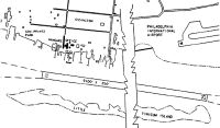
Maps & Diagrams
PSQ Sectional
Flight Planning
at skyvector.com
at skyvector.com