Location
Latitude: |
46-15-52.8540N (46.264682) |
Longitude: |
119-07-08.4860W (-119.119024) |
Elevation: |
410.4 feet MSL (125 m MSL) |
Magnetic Variation: |
14.2 E (as of April 2024 from WMM2020 model) |
Time Zone: |
UTC -8.0 (Standard Time) UTC -7.0 (Daylight Savings Time) |
From City: |
02 N.M. NW of Pasco, Washington |
Found On: |
Seattle Chart |
FAA Region: |
ANM |
Contacts
Manager: |
Publicly owned: |
| DONALD 'BUCK' TAFT 3601 N 20TH AVE PASCO, WA 99301 509-547-6352 |
PORT OF PASCO 3601 N 20TH AVE PASCO, WA 99301 509-547-6352 |
Operations
Airport Status: |
Operational |
Facility Use: |
Public |
Type: |
Airport |
Activation Date: |
11/1937 |
Control tower: |
Yes |
Attendance (Months/Days/Hours): |
Months/Days/Hours ALL/ALL/0800-2000 |
Boundary ARTCC: |
ZSE (Seattle) |
Responsible ARTCC: |
ZSE (Seattle) |
Lighting Schedule: |
SEE RMK |
Segmented Circle Indicator: |
Yes |
Traffic Pattern Altitude (MSL): |
1410 feet (430 m) |
NOTAMs Facility: |
PSC |
NOTAM-D Service: |
Yes |
International Airport of Entry: |
No |
Customs Landing Rights: |
No |
Military Landing Rights: |
Yes |
Civil/Military Joint Use: |
No |
Aircraft Rescue and Firefighting: |
Class I ARFF Index: B Air Carrier Service: Scheduled Certification Date: 05/1973 |
Based Aircraft
| Single Engine: | 80 |
| Multi Engine: | 23 |
| Jet Engine: | 14 |
| GA Helicopters: | 4 |
Annual Operations (as of 12/31/2018)
| Total Operations: | 48211 | |
| Commercial: | 9154 | 19.0% |
| Air Taxi: | 4453 | 9.2% |
| GA Local: | 15744 | 32.7% |
| GA Itinerant: | 16541 | 34.3% |
| Military Aircraft: | 2319 | 4.8% |
Communications
| CTAF: | 135.300 |
| Unicom: | 122.950 |
| Tower: | TRI-CITIES 135.3 323.3 Hrs: 0600-2200 |
| Clearance Del.: | 120.0 |
| Ground: | 121.8 |
| Approach: | SPOKANE 128.75 ;NORTH & WEST 128.75 ;NORTH & WEST 128.75 ;NORTH & WEST 128.75 ;NORTH & WEST SEATTLE ARTCC |
| Departure: | SPOKANE 128.75 ;NORTH & WEST 128.75 ;NORTH & WEST 128.75 ;NORTH & WEST 128.75 ;NORTH & WEST SEATTLE ARTCC |
| ATIS: | 125.65 Hrs: 24 |
| ASOS: | (509-547-7379) |
- COMMUNICATIONS PRVDD BY SEATTLE RADIO ON FREQ 122.4 (JUMP-OFF-JOE RCO).
- APCH/DEP CTL SVC PROVDD BY SEATTLE ARTCC (ZSE) ON 132.6/269.35 (YAKIMA RCAG), WHEN GEG APCH CLSD.
Fixed Based Operators (FBOs) & Fuel
(Click on a business for detail)
Please help us keep this information up to date. This is a FREE SERVICE just like everything else on Airport Guide! If you see that a business needs to be added, modified, or deleted please fill out our Update Form.
To add, modify, or delete a business click here.
Please help us keep this information up to date. This is a FREE SERVICE just like everything else on Airport Guide! If you see that a business needs to be added, modified, or deleted please fill out our Update Form.
Area Code: 509 |
| Business Name | Frequency | Phone | Fuel Grade |
|---|---|---|---|
| Bergstrom Aircraft
Update FBO info |
Unicom 122.95 | 547-6271 | 100LL, Jet A |
| Inter Avionics
Update FBO info |
547-3004 |
Flight Service Stations
| Primary | Alternate | |
| FSS on Field: | N | |
| FSS Name (ID): | Seattle(SEA) | |
| Frequency: | ||
| Toll Free Phone: | 1-800-WX-BRIEF |
Instrument Procedures / Charts
FAA Terminal Procedures valid from 0901Z 03/21/24 to 0901Z 04/18/24.
There are various types of charts available for an airport. They are listed in the Page Type column. Here is a legend for those types:
APD - Airport Diagram
DP - Departure Procedure Charts
HOT - Hot Spots
IAP - Instrument Approach Procedure Charts
MIN - Minimums
STAR - Standard Terminal Arrival Charts
| Page Type | Page Name | Volume | Action Since Last Cycle |
|---|---|---|---|
| APD | AIRPORT DIAGRAM | NW-1 | |
| DP | TRI-CITIES SEVEN | NW-1 | |
| HOT | HOT SPOT | NW-1 | |
| IAP | ILS OR LOC RWY 21R | NW-1 | |
| IAP | RNAV (GPS) Y RWY 03L | NW-1 | |
| IAP | RNAV (GPS) Y RWY 12 | NW-1 | |
| IAP | RNAV (GPS) Y RWY 21R | NW-1 | |
| IAP | RNAV (GPS) Y RWY 30 | NW-1 | |
| IAP | RNAV (RNP) Z RWY 03L | NW-1 | |
| IAP | RNAV (RNP) Z RWY 12 | NW-1 | |
| IAP | RNAV (RNP) Z RWY 21R | NW-1 | |
| IAP | RNAV (RNP) Z RWY 30 | NW-1 | |
| IAP | VOR RWY 21R | NW-1 | |
| IAP | VOR RWY 30 | NW-1 | |
| MIN | ALTERNATE MINIMUMS | NW-1 | |
| MIN | DIVERSE VECTOR AREA | NW-1 | |
| MIN | TAKEOFF MINIMUMS | NW-1 |
Terminal Procedures are only available for airports in several countries with more being added all the time. If you are looking for a specific country's charts, please send an email to support(at)airportguide.com stating the country name. This will be used to prioritize the implementation.
Navigation Aids (Navaids) near PSC
| Dist (NM) | ID | Morse Code | Name | Type | Freq | True Hdg | Mag Hdg |
|---|---|---|---|---|---|---|---|
| 0.3 | PSC | . _ _ . . . . _ . _ . | Pasco | VOR-DME | 113.75 | 11 | 357 |
| 34.8 | PDT | . _ _ . _ . . _ | Pendleton | VORTAC | 114.70 | 167 | 153 |
| 36.0 | ALW | . _ . _ . . . _ _ | Walla Walla | VOR-DME | 116.40 | 106 | 92 |
| 37.8 | PD | . _ _ . _ . . | Foris | NDB | 230 | 154 | 140 |
| 38.7 | AL | . _ . _ . . | Trina | NDB | 353 | 97 | 83 |
| 51.5 | MW | _ _ . _ _ | Pelly | NDB | 408 | 352 | 338 |
| 54.2 | YK | _ . _ _ _ . _ | Donny | NDB | 371 | 287 | 273 |
| 57.4 | MWH | _ _ . _ _ . . . . | Moses Lake | VOR-DME | 115.00 | 351 | 337 |
| 57.8 | YKM | _ . _ _ _ . _ _ _ | Yakima | VORTAC | 116.00 | 288 | 274 |
| 68.0 | EPH | . . _ _ . . . . . | Ephrata | VORTAC | 112.60 | 349 | 335 |
| 71.6 | ELN | . . _ . . _ . | Ellensburg | VOR-DME | 117.90 | 310 | 296 |
| 73.5 | LGD | . _ . . _ _ . _ . . | La Grande | NDB | 296 | 138 | 124 |
| 81.5 | EAT | . . _ _ | Wenatchee | VOR-DME | 111.00 | 327 | 313 |
| 82.1 | PUW | . _ _ . . . _ . _ _ | Pullman | VOR-DME | 117.15 | 71 | 57 |
| 89.0 | LTJ | . _ . . _ . _ _ _ | Klickitat | VOR-DME | 112.30 | 248 | 234 |
| 93.5 | MQG | _ _ _ _ . _ _ _ . | Nez Perce | VOR-DME | 114.45 | 84 | 70 |
| 99.1 | GEG | _ _ . . _ _ . | Spokane | VORTAC | 115.50 | 37 | 23 |
Nearby Airports with Fuel
Notices to Airmen (NOTAMS)
Remarks
| A110-1 | BIRD HAZARD; SEE SPECIAL NOTICE FOR WASHINGTON IN AIM PART 3A. |
| A110-2 | TPA 1500' TURBINE PWRD ACFT; ALL OTRS 1000'. |
| A110-3 | RY 03R/21L IS AVBL FOR ACR ACFT FOR TAXIING DURING DALGT AND VFR CONDITIONS ONLY. |
| A110-4 | RY 21L & 03R NOT AVBL AS MOVEMENT AREA FOR ACR ACFT WITH MORE THAN 9 PSGR SEATS OR GREATER FOR LNDG AND TKOF. |
| A110-5 | WATER FOWL ON & INVOF ARPT SPRING & FALL. |
| A110-6 | TWY G, G1 & E2 LTD TO USE BY ACFT UP TO 100000 LBS AND LESS THAN 20 FT MAIN GEAR WID. |
| A26 | PPR UNSKED ACR OPNS WITH MORE THAN 30 PSGR SEATS CALL AMGR 509-547-6352. |
| A33-03R/21L | RY 03R/21L SFC CRACKING. |
| A57-21R | +81' TWR 3036' & 900'L 37:1 BASED ON DSPLCD THR. |
| A70-FUEL-10 | 0LL AFTER HOURS FUEL CALL (509) 547-6271 OR (509) 545-5524. CALL-OUT FEE. FUEL 24 HR CREDIT CARD SVC AVBL. |
| A81-APT | WHEN ATCT CLSD HIRL RY 03L/21R AND MIRL RY 12/30 PRESET ON LOW INTST TO INCREASE INTST AND ACTVT MALSR RY 21R & ODALS RY 30 - CTAF. |
| E111 | ESTAB PRIOR TO 15 MAY 1959. |
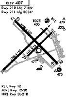
Runways
Runway Summary
| Runways: | 03L/21R 03R/21L 12/30 |
| Longest Runway: | 03L/21R is 7707 ft (2349 m) long |
| Runways with an Instrument Approach: | 21R |
PSC Airport Runway Details
| Runway 03L/21R | 7707 ft x 150 ft (2349 m x 46 m) | |
| Runway Length Source: | 3RD PARTY SURVEY as of 03/19/2019 | |
| Surface: | Asphalt - Good condition - Saw-cut or plastic grooved | |
| Runway Pavement Class: | 47 /F/B/X/T | |
| Runway Edge Lights: | High Intensity | |
Runway Weight Bearing Capacity (in thousands of pounds) |
||
| Single Wheel Landing Gear: | 150.0 | |
| Dual Wheel Landing Gear: | 200.0 | |
| Dual Tandem Wheel Landing Gear: | 400.0 | |
Runway 03L |
Runway 21R |
|
Elevation: |
409.8 | 401.3 |
Latitude: |
46-15-21.4457N | 46-16-14.5522N |
Longitude: |
119-08-00.5699W | 119-06-42.0247W |
|
Runway True Alignment: |
045 | 225 |
ILS Type: |
ILS/DME | |
Glide Path Angle: |
3.0 degrees | 3.0 degrees |
Traffic Pattern: |
Left | Right |
Runway Markings Type: |
Nonprecision Instrument | Precision Instrument |
Runway Markings Condition: |
Good | Good |
Object at End: |
TREE | POLE |
Object Height: |
61 | 49 |
Distance from End: |
2550 | 1900 |
Object Centerline Offset: |
750 ft. right of centerline | 450 ft. left of centerline |
Visual Glide Slope Indicators: |
4-Light PAPI On Left Side Of Runway | 4-Light PAPI On Left Side Of Runway |
Runway Visual Range (RVR): |
Rollout | Touchdown |
Approach Light System: |
1,400 Foot Medium Intensity Approach Lighting System With Runway Alignment Indicator Lights | |
REIL: |
Yes | |
Threshold Crossing Height: |
49 | 54 |
Threshold Elevation: |
401.8 | |
Displaced Threshold: |
597 | |
Threshold Latitude: |
46-16-10.4370N | |
Threshold Longitude: |
119-06-48.1128W | |
Declared Distances |
||
Take Off Run Avbl. (TORA): |
7707 | 7707 |
Take Off Distance Avbl. (TODA): |
7707 | 7707 |
Actual Stop Dist. Avbl. (ASDA): |
7707 | 7707 |
Landing Dist. Avbl. (LDA): |
7707 | 7110 |
| Runway 03R/21L | 4423 ft x 75 ft (1348 m x 23 m) | |
| Runway Length Source: | 3RD PARTY SURVEY as of 03/19/2019 | |
| Surface: | Asphalt - Good condition - No special surface treatment | |
| Runway Pavement Class: | 13 /F/B/X/T | |
Runway Weight Bearing Capacity (in thousands of pounds) |
||
| Single Wheel Landing Gear: | 52.0 | |
| Dual Wheel Landing Gear: | 85.0 | |
| Dual Tandem Wheel Landing Gear: | 108.0 | |
| Dual Dual Tandem Wheel Landing Gear: | 150.0 | |
Runway 03R |
Runway 21L |
|
Elevation: |
402.9 | 403.8 |
Latitude: |
46-15-38.3561N | 46-16-08.8272N |
Longitude: |
119-07-19.2675W | 119-06-34.1837W |
|
Runway True Alignment: |
045 | 225 |
Glide Path Angle: |
0.0 degrees | 0.0 degrees |
Traffic Pattern: |
Right | Left |
Runway Markings Type: |
Basic | Basic |
Runway Markings Condition: |
Good | Good |
Object at End: |
TOWER | |
Object Height: |
79 | |
Distance from End: |
2445 | |
Object Centerline Offset: |
750 ft. right of centerline | 450 ft. left of centerline |
Declared Distances |
||
Take Off Run Avbl. (TORA): |
4423 | 4423 |
Take Off Distance Avbl. (TODA): |
4423 | 4423 |
Actual Stop Dist. Avbl. (ASDA): |
4423 | 4423 |
Landing Dist. Avbl. (LDA): |
4423 | 4423 |
| Runway 12/30 | 7704 ft x 150 ft (2348 m x 46 m) | |
| Runway Length Source: | 3RD PARTY SURVEY as of 03/19/2019 | |
| Surface: | Asphalt - Good condition - Saw-cut or plastic grooved | |
| Runway Pavement Class: | 53 /F/C/X/T | |
| Runway Edge Lights: | Medium Intensity | |
Runway Weight Bearing Capacity (in thousands of pounds) |
||
| Single Wheel Landing Gear: | 150.0 | |
| Dual Wheel Landing Gear: | 200.0 | |
| Dual Tandem Wheel Landing Gear: | 400.0 | |
Runway 12 |
Runway 30 |
|
Elevation: |
395.6 | 402.0 |
Latitude: |
46-16-24.5104N | 46-15-30.0479N |
Longitude: |
119-07-40.6906W | 119-06-24.1669W |
|
Runway True Alignment: |
135 | 315 |
Glide Path Angle: |
3.0 degrees | 3.0 degrees |
Traffic Pattern: |
Left | Left |
Runway Markings Type: |
Nonprecision Instrument | Nonprecision Instrument |
Runway Markings Condition: |
Good | Good |
Object at End: |
TREE | |
Object Height: |
30 | |
Distance from End: |
1312 | |
Object Centerline Offset: |
750 ft. right of centerline | 450 ft. left of centerline |
Visual Glide Slope Indicators: |
4-Box VASI On Left Side Of Runway | 4-Light PAPI On Left Side Of Runway |
Approach Light System: |
Omnidirectional Approach Lighting System | |
REIL: |
Yes | |
Threshold Crossing Height: |
56 | 54 |
Threshold Elevation: |
402.0 | |
Displaced Threshold: |
200 | |
Threshold Latitude: |
46-15-31.4619N | |
Threshold Longitude: |
119-06-26.1557W | |
Declared Distances |
||
Take Off Run Avbl. (TORA): |
7704 | 7704 |
Take Off Distance Avbl. (TODA): |
7704 | 7704 |
Actual Stop Dist. Avbl. (ASDA): |
7504 | 7704 |
Landing Dist. Avbl. (LDA): |
7504 | 7504 |
Services
Airframe Repair: |
Minor |
Powerplant Repair: |
Minor |
Bottled Oxygen: |
None |
Bulk Oxygen: |
None |
Fuel Available: |
100LL, Jet A |
Landing Fees: |
No |
Parking: |
Tiedowns available |
Maps & Diagrams
PSC Sectional
Flight Planning
at skyvector.com
at skyvector.com