Location
Latitude: |
39-43-13.4000N (39.720389) |
Longitude: |
122-08-46.9000W (-122.146361) |
Elevation: |
217.7 feet MSL (66 m MSL) |
Magnetic Variation: |
13.4 E (as of April 2024 from WMM2020 model) |
Time Zone: |
UTC -8.0 (Standard Time) UTC -7.0 (Daylight Savings Time) |
From City: |
03 N.M. SE of Orland, California |
Found On: |
San Francisco Chart |
FAA Region: |
AWP |
Contacts
Manager: |
Publicly owned: |
| DONALD RUST PO BOX 1070 WILLOWS, CA 95988 530-934-6530 |
GLENN COUNTY 525 SYCAMORE ST., STE B1 WILLOWS, CA 95988 530-934-6400 |
Operations
Airport Status: |
Operational |
Facility Use: |
Public |
Type: |
Airport |
Activation Date: |
09/1947 |
Control tower: |
No |
Attendance (Months/Days/Hours): |
Months/Days/Hours ALL/MON-FRI/0700-1530 |
Boundary ARTCC: |
ZOA (Oakland) |
Responsible ARTCC: |
ZOA (Oakland) |
Lighting Schedule: |
SEE RMK |
Segmented Circle Indicator: |
Yes |
Traffic Pattern Altitude (MSL): |
1218 feet (371 m) |
NOTAMs Facility: |
RIU |
NOTAM-D Service: |
Yes |
International Airport of Entry: |
No |
Customs Landing Rights: |
No |
Military Landing Rights: |
Yes |
Civil/Military Joint Use: |
No |
Based Aircraft
| Single Engine: | 41 |
| Multi Engine: | 2 |
| GA Helicopters: | 1 |
Annual Operations (as of 12/31/2021)
| Total Operations: | 20000 | |
| GA Local: | 8000 | 40.0% |
| GA Itinerant: | 12000 | 60.0% |
Communications
| CTAF: | 122.700 |
| Unicom: | 122.700 |
- APCH/DEP CTL SVC PRVDD BY OAKLAND ARTCC (ZOA) ON FREQS 132.2/350.3 (RED BLUFF RCAG).
Fixed Based Operators (FBOs) & Fuel
(Click on a business for detail)
Please help us keep this information up to date. This is a FREE SERVICE just like everything else on Airport Guide! If you see that a business needs to be added, modified, or deleted please fill out our Update Form.
To add, modify, or delete a business click here.
Please help us keep this information up to date. This is a FREE SERVICE just like everything else on Airport Guide! If you see that a business needs to be added, modified, or deleted please fill out our Update Form.
Area Code: 530 |
| Business Name | Frequency | Phone | Fuel Grade |
|---|---|---|---|
| Airport Management
Update FBO info |
Unicom 122.7 | 865-9968 | 80, 100LL |
| Herfi Aircraft
Update FBO info |
865-2861 | ||
| Thompson Aviation
Update FBO info |
865-9344 |
Flight Service Stations
| Primary | Alternate | |
| FSS on Field: | N | |
| FSS Name (ID): | Rancho Murieta(RIU) | |
| Frequency: | ||
| Toll Free Phone: | 1-800-WX-BRIEF |
Instrument Procedures / Charts
FAA Terminal Procedures valid from 0901Z 03/21/24 to 0901Z 04/18/24.
There are various types of charts available for an airport. They are listed in the Page Type column. Here is a legend for those types:
APD - Airport Diagram
DP - Departure Procedure Charts
HOT - Hot Spots
IAP - Instrument Approach Procedure Charts
MIN - Minimums
STAR - Standard Terminal Arrival Charts
| Page Type | Page Name | Volume | Action Since Last Cycle |
|---|---|---|---|
| IAP | RNAV (GPS)-A | SW-2 | |
| MIN | TAKEOFF MINIMUMS | SW-2 |
Terminal Procedures are only available for airports in several countries with more being added all the time. If you are looking for a specific country's charts, please send an email to support(at)airportguide.com stating the country name. This will be used to prioritize the implementation.
Navigation Aids (Navaids) near O37
| Dist (NM) | ID | Morse Code | Name | Type | Freq | True Hdg | Mag Hdg |
|---|---|---|---|---|---|---|---|
| 14.4 | CIC | _ . _ . . . _ . _ . | Chico | VOR-DME | 109.80 | 73 | 60 |
| 23.1 | RBL | . _ . _ . . . . _ . . | Red Bluff | VORTAC | 115.70 | 349 | 336 |
| 24.0 | PBT | . _ _ . _ . . . _ | Proberta | NDB | 338 | 349 | 336 |
| 24.4 | MXW | _ _ _ . . _ . _ _ | Maxwell | VORTAC | 110.00 | 188 | 175 |
| 39.3 | ILA | . . . _ . . . _ | Williams | VORTAC | 114.40 | 171 | 158 |
| 41.4 | MY | _ _ _ . _ _ | Halow | NDB | 222 | 142 | 129 |
| 45.8 | MYV | _ _ _ . _ _ . . . _ | Marysville | VOR-DME | 110.80 | 144 | 131 |
| 47.5 | RDD | . _ . _ . . _ . . | Redding | VOR-DME | 114.35 | 351 | 338 |
| 48.0 | BAB | _ . . . . _ _ . . . | Beale | TACAN | 108.60 | 136 | 123 |
| 57.3 | UK | . . _ _ . _ | Kearn | NDB | 371 | 242 | 229 |
| 65.9 | ENI | . _ . . . | Mendocino | VORTAC | 112.30 | 232 | 219 |
| 67.0 | SMF | . . . _ _ . . _ . | Sacramento Intl | VOT | 111.40 | 157 | 144 |
| 72.0 | MCC | _ _ _ . _ . _ . _ . | Mc Clellan | VOR-DME | 109.20 | 151 | 138 |
| 78.7 | SAC | . . . . _ _ . _ . | Sacramento Executive | VOT | 111.40 | 157 | 144 |
| 79.0 | STS | . . . _ . . . | Santa Rosa | DME | 116.15 | 203 | 190 |
| 81.5 | SAC | . . . . _ _ . _ . | Sacramento | VORTAC | 115.20 | 159 | 146 |
| 84.0 | TZZ | _ _ _ . . _ _ . . | Travis | VOR | 116.40 | 169 | 156 |
| 88.2 | HNW | . . . . _ . . _ _ | Hangtown | VOR-DME | 115.50 | 132 | 119 |
| 89.0 | SUU | . . . . . _ . . _ | Travis | TACAN | 116.60 | 173 | 160 |
| 92.8 | SWR | . . . . _ _ . _ . | Squaw Valley | VOR-DME | 113.20 | 109 | 96 |
Nearby Airports with Fuel
Notices to Airmen (NOTAMS)
Remarks
| A110-1 | FOR CD CTC OAKLAND ARTCC AT 510-745-3380. |
| A14 | DIRECTOR PUBLIC WORKS |
| A16 | OFFICE AT ORLAND ARPT PHONE 530-624-0836. |
| A81-APT | ACTVT MIRL RWY 15/33 - CTAF. |
| A96 | ULTRALIGHT ACTIVITY ON & INVOF ARPT. |
Runways
Runway Summary
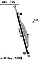
| Runways: | 15/33 |
| Longest Runway: | 15/33 is 4500 ft (1372 m) long |
| Runways with an Instrument Approach: |
O37 Airport Runway Details
| Runway 15/33 | 4500 ft x 60 ft (1372 m x 18 m) | |
| Runway Length Source: | 3RD PARTY SURVEY as of 04/02/2010 | |
| Surface: | Asphalt - Good condition - No special surface treatment | |
| Runway Edge Lights: | Medium Intensity | |
Runway Weight Bearing Capacity (in thousands of pounds) |
||
| Single Wheel Landing Gear: | 30.0 | |
Runway 15 |
Runway 33 |
|
Elevation: |
217.7 | 209.7 |
Latitude: |
39-43-34.9430N | 39-42-51.8646N |
Longitude: |
122-08-54.0871W | 122-08-39.7809W |
|
Runway True Alignment: |
166 | 346 |
Glide Path Angle: |
3.5 degrees | 3.5 degrees |
Traffic Pattern: |
Left | Left |
Runway Markings Type: |
Basic | Basic |
Runway Markings Condition: |
Fair | Fair |
Object at End: |
ROAD | POLE |
Object Height: |
15 | 30 |
Distance from End: |
700 | 1200 |
Object Centerline Offset: |
125 ft. left of centerline | 125 ft. left of centerline |
Visual Glide Slope Indicators: |
2-Light PAPI On Left Side Of Runway | 2-Light PAPI On Left Side Of Runway |
REIL: |
No | No |
Touchdown Lights: |
No | No |
Centerline Lights: |
No | No |
Threshold Crossing Height: |
28 | 27 |
Services
Airframe Repair: |
Major |
Powerplant Repair: |
Major |
Bottled Oxygen: |
None |
Bulk Oxygen: |
None |
Fuel Available: |
100LL, Jet A |
Landing Fees: |
No |
Parking: |
Tiedowns available |
Maps & Diagrams
O37 Sectional
Flight Planning
at skyvector.com
at skyvector.com