
Location
Latitude: |
47-09-11.5137N (47.153198) |
Longitude: |
001-36-38.6282W (-1.61073) |
Elevation: |
90 feet MSL (27 m MSL) |
Magnetic Variation: |
0.7 E (as of April 2024 from WMM2020 model) |
Time Zone: |
UTC +1.0 (Standard Time) UTC +2.0 (Daylight Savings Time) |
Contacts
Manager: |
: |
Operations
Airport Status: |
Operational |
Facility Use: |
Public |
Type: |
Airport |
Traffic Pattern Altitude (MSL): |
1090 feet (332 m) |
Based Aircraft
Annual Operations (as of )
Communications
| INFO: | 129.875 |
| TWR: | 118.65 |
| GND: | 121.875 |
| APP: | 130.275 |
| ATIS: | 126.925 |
Fixed Based Operators (FBOs) & Fuel
(Click on a business for detail)
Please help us keep this information up to date. This is a FREE SERVICE just like everything else on Airport Guide! If you see that a business needs to be added, modified, or deleted please fill out our Update Form.
To add, modify, or delete a business click here.
Please help us keep this information up to date. This is a FREE SERVICE just like everything else on Airport Guide! If you see that a business needs to be added, modified, or deleted please fill out our Update Form.
| Business Name | Frequency | Phone | Fuel Grade |
|---|---|---|---|
| Aviapartner
Website Update FBO info |
131.625 | 0033 (0)2 40 84 95 06 0033 (0) 6 86 56 20 97 0033 (0) 612 87 68 77 |
Flight Service Stations
| Primary | Alternate | |
| FSS on Field: | ||
| FSS Name (ID): | ||
| Frequency: | ||
| Toll Free Phone: |
Instrument Procedures / Charts
Terminal Procedures are only available for airports in several countries with more being added all the time. If you are looking for a specific country's charts, please send an email to support(at)airportguide.com stating the country name. This will be used to prioritize the implementation.
Navigation Aids (Navaids) near NTE
| Dist (NM) | ID | Morse Code | Name | Type | Freq | True Hdg | Mag Hdg |
|---|---|---|---|---|---|---|---|
| 0.5 | NTS | Nantes | VOR-DME | 115.50 | 348 | 347 | |
| 6.8 | GL | Nantes | NDB | 369 | 207 | 206 | |
| 20.7 | MT | Saint Nazaire/Montoir | NDB | 398 | 301 | 300 | |
| 30.9 | YN | La Roche Sur Yon | NDB | 334 | 154 | 153 | |
| 38.5 | ANG | Angers | VOR | 113.00 | 52 | 51 | |
| 55.2 | REN | Rennes | VOR-DME | 109.25 | 354 | 353 | |
| 61.3 | SR | Saumur | NDB | 372 | 83 | 82 | |
| 82.7 | LOR | Lorient | TACAN | 115.80 | 296 | 296 | |
| 82.8 | LOR | Lorient | NDB | 359 | 296 | 296 | |
| 84.8 | LM | Le Mans | NDB | 326 | 57 | 56 | |
| 85.5 | POI | Poitiers | VOR | 113.30 | 112 | 111 | |
| 87.0 | PI | Poitiers | NDB | 363 | 107 | 106 | |
| 88.0 | DIN | Dinard | VOR-DME | 114.30 | 347 | 346 | |
| 96.7 | TUR | Tours | TACAN | 113.80 | 79 | 78 |
Nearby Airports with Fuel
| Dist (NM) | Name (Airport IDs) | True Hdg | Mag Hdg | Fuel Grade |
|---|
Notices to Airmen (NOTAMS)
Remarks
No remarks for this landing facility
Runways
Runway Summary
| Runways: | 03/21 |
| Longest Runway: | 03/21 is 9514 ft (2900 m) long |
| Runways with an Instrument Approach: |
NTE Airport Runway Details
| Runway 03/21 | 9514 ft x 148 ft (2900 m x 45 m) | |
| Runway Edge Lights: | Yes Intensity | |
Runway 03 |
Runway 21 |
|
Elevation: |
73 | 86 |
Latitude: |
47.1416015625 | 47.16479873657 |
Longitude: |
-1.619539976119 | -1.601899981498 |
|
Runway True Alignment: |
28 | 208 |
Glide Path Angle: |
0.0 degrees | 0.0 degrees |
REIL: |
Yes | Yes |
Threshold Elevation: |
73 | 86 |
Displaced Threshold: |
694 |
Services
Other Services: |
Ground Handling - Passenger Services, Ramp Services, Traffic Operations Cargo Services The FBO services we provide are: • Domestic & international handling • Fast turnarounds • Passenger & crew assistance • Airport & airway slot coordination • Flight planning & weather - NOTAMs • Traffic rights & landing permits • Aircraft charter reservation • Catering arrangements • Hotel & restaurant reservations • Limousine & car rental • Customs & immigration assistance • Change aircraft charter reservation (by aircraft & helicopter charter) • Fueling and fueling arrangements |
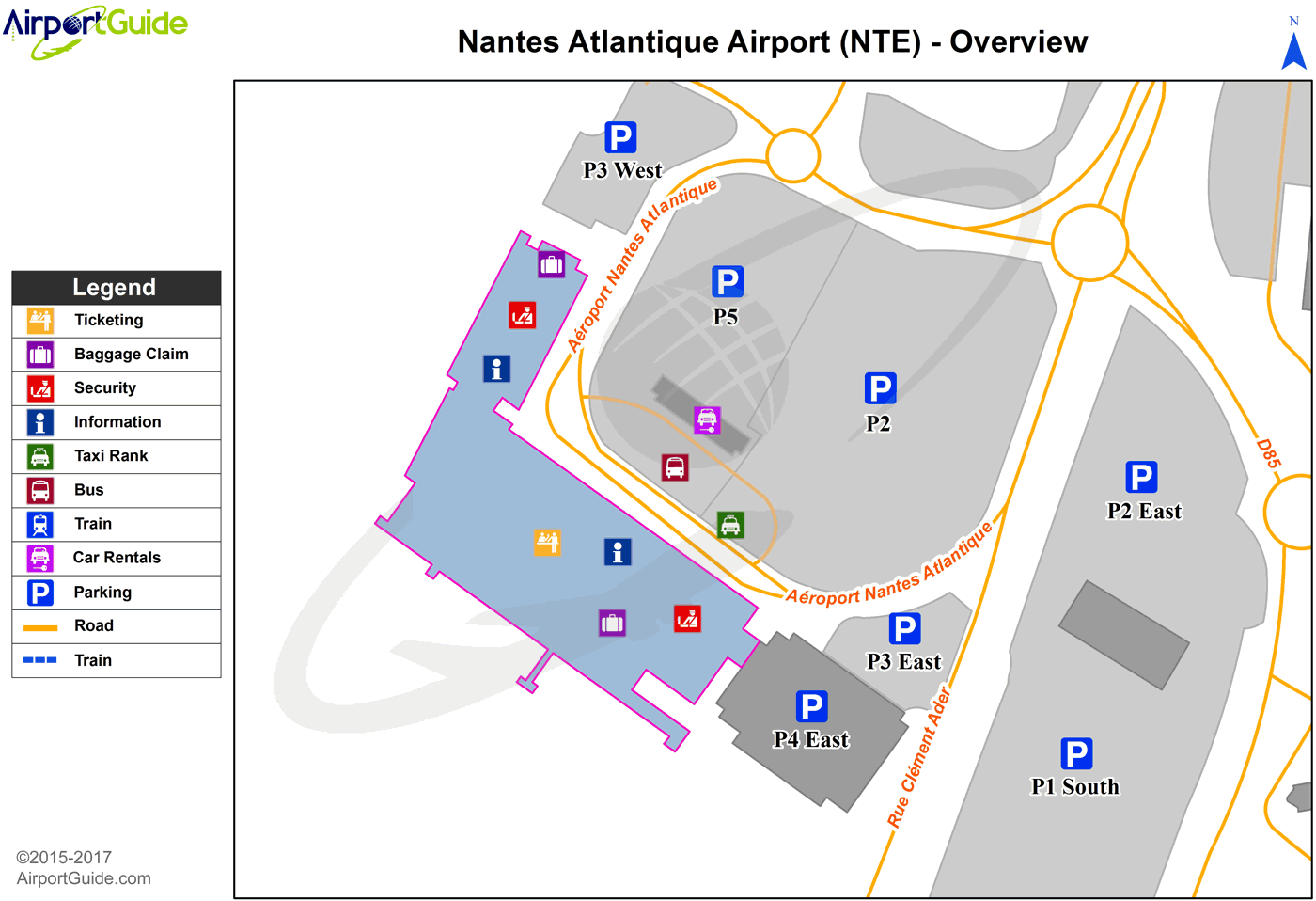
Maps & Diagrams
NTE Sectional
Flight Planning
at skyvector.com
at skyvector.com
