Location
Latitude: |
43-06-37.3680N (43.11038) |
Longitude: |
088-02-03.9060W (-88.034418) |
Elevation: |
744.8 feet MSL (227 m MSL) |
Magnetic Variation: |
4 W (as of April 2024 from WMM2020 model) |
Time Zone: |
UTC -6.0 (Standard Time) UTC -5.0 (Daylight Savings Time) |
From City: |
05 N.M. NW of Milwaukee, Wisconsin |
Found On: |
Chicago Chart |
FAA Region: |
AGL |
Contacts
Manager: |
Publicly owned: |
| BRIAN DRANZIK 5300 S HOWELL MILWAUKEE, WI 53207 414-747-5300 |
MILWAUKEE COUNTY COUNTY COURTHOUSE MILWAUKEE, WI 53233 414-747-5300 |
Operations
Airport Status: |
Operational |
Facility Use: |
Public |
Type: |
Airport |
Activation Date: |
08/1937 |
Control tower: |
Yes |
Attendance (Months/Days/Hours): |
Months/Days/Hours ALL/ALL/0800-1600 |
Boundary ARTCC: |
ZAU (Chicago) |
Responsible ARTCC: |
ZAU (Chicago) |
Lighting Schedule: |
SEE RMK |
Segmented Circle Indicator: |
No |
Traffic Pattern Altitude (MSL): |
1745 feet (532 m) |
NOTAMs Facility: |
MWC |
NOTAM-D Service: |
Yes |
International Airport of Entry: |
No |
Customs Landing Rights: |
No |
Military Landing Rights: |
Yes |
Civil/Military Joint Use: |
No |
Based Aircraft
| Single Engine: | 78 |
| Multi Engine: | 8 |
| Jet Engine: | 3 |
| GA Helicopters: | 1 |
Annual Operations (as of 04/30/2023)
| Total Operations: | 27266 | |
| Commercial: | 8 | 0.0% |
| Air Taxi: | 528 | 1.9% |
| GA Local: | 15113 | 55.4% |
| GA Itinerant: | 11416 | 41.9% |
| Military Aircraft: | 201 | 0.7% |
Communications
| CTAF: | 120.500 |
| Unicom: | 122.950 |
| Tower: | TIMMERMAN 120.5 Hrs: 0700-2100 |
| Clearance Del.: | 121.7 ;WHEN TWR CLSD 121.7 ;WHEN TWR CLSD 121.7 ;WHEN TWR CLSD 121.7 ;WHEN TWR CLSD 121.7 ;WHEN TWR CLSD |
| Ground: | 121.7 |
| Approach: | MILWAUKEE |
| Departure: | MILWAUKEE |
| ATIS: | 128.3 Hrs: 24 |
| AWOS-3: | (414-461-2954) |
Fixed Based Operators (FBOs) & Fuel
(Click on a business for detail)
Please help us keep this information up to date. This is a FREE SERVICE just like everything else on Airport Guide! If you see that a business needs to be added, modified, or deleted please fill out our Update Form.
To add, modify, or delete a business click here.
Please help us keep this information up to date. This is a FREE SERVICE just like everything else on Airport Guide! If you see that a business needs to be added, modified, or deleted please fill out our Update Form.
Area Code: 414 |
| Business Name | Frequency | Phone | Fuel Grade |
|---|---|---|---|
| Gran-Aire, Inc.
Update FBO info |
Unicom 122.95 | 461-3222 | 100LL, Jet A |
| Skycom Avionics, Inc.
Update FBO info |
123.4 | 463-8180 |
Flight Service Stations
| Primary | Alternate | |
| FSS on Field: | N | |
| FSS Name (ID): | Green Bay(GRB) | |
| Frequency: | ||
| Toll Free Phone: | 1-800-WX-BRIEF |
Instrument Procedures / Charts
FAA Terminal Procedures valid from 0901Z 03/21/24 to 0901Z 04/18/24.
There are various types of charts available for an airport. They are listed in the Page Type column. Here is a legend for those types:
APD - Airport Diagram
DP - Departure Procedure Charts
HOT - Hot Spots
IAP - Instrument Approach Procedure Charts
MIN - Minimums
STAR - Standard Terminal Arrival Charts
| Page Type | Page Name | Volume | Action Since Last Cycle |
|---|---|---|---|
| APD | AIRPORT DIAGRAM | EC-3 | |
| DP | ACCRA FIVE (RNAV) | EC-3 | |
| DP | UECKR SIX (RNAV) | EC-3 | |
| IAP | LOC RWY 15L | EC-3 | |
| IAP | RNAV (GPS) RWY 04L | EC-3 | |
| IAP | RNAV (GPS) RWY 15L | EC-3 | |
| IAP | RNAV (GPS) RWY 22R | EC-3 | |
| MIN | ALTERNATE MINIMUMS | EC-3 | |
| MIN | TAKEOFF MINIMUMS | EC-3 | |
| STAR | GOPAC THREE (RNAV) | EC-3 |
Terminal Procedures are only available for airports in several countries with more being added all the time. If you are looking for a specific country's charts, please send an email to support(at)airportguide.com stating the country name. This will be used to prioritize the implementation.
Navigation Aids (Navaids) near MWC
| Dist (NM) | ID | Morse Code | Name | Type | Freq | True Hdg | Mag Hdg |
|---|---|---|---|---|---|---|---|
| 0.1 | LJT | . _ . . . _ _ _ _ | Timmerman | DME | 115.65 | 254 | 258 |
| 7.5 | BL | _ . . . . _ . . | Yanks | NDB | 260 | 113 | 117 |
| 11.0 | BAE | _ . . . . _ . | Badger | VOR-DME | 116.40 | 272 | 276 |
| 11.5 | MKE | _ _ _ . _ . | Milwaukee | VOT | 109.00 | 148 | 152 |
| 12.1 | GM | _ _ . _ _ | Teels | NDB | 242 | 181 | 185 |
| 19.1 | BJB | _ . . . . _ _ _ _ . . . | West Bend | VOR | 109.80 | 348 | 352 |
| 23.0 | HRK | . . . . . _ . _ . _ | Horlick | DME | 114.05 | 155 | 159 |
| 26.3 | RA | . _ . . _ | Paser | NDB | 206 | 166 | 170 |
| 27.9 | BUU | _ . . . . . _ . . _ | Burbun | DME | 114.5 | 205 | 209 |
| 30.5 | RYV | . _ . _ . _ _ . . . _ | Rock River | NDB | 371 | 277 | 281 |
| 31.0 | ENW | . _ . . _ _ | Kenosha | DME | 109.2 | 171 | 175 |
| 33.0 | EN | . _ . | Codee | NDB | 389 | 179 | 183 |
| 34.8 | LVV | . _ . . . . . _ . . . _ | Lake Lawn | NDB | 404 | 225 | 229 |
| 34.9 | UNU | . . _ _ . . . _ | Juneau | NDB | 344 | 303 | 307 |
| 40.1 | UG | . . _ _ _ . | Wauke | NDB | 379 | 165 | 169 |
| 40.3 | FAH | . . _ . . _ . . . . | Falls | DME | 110 | 11 | 15 |
| 51.2 | OS | _ _ _ . . . | Pober | NDB | 395 | 333 | 337 |
| 53.3 | JVL | . _ _ _ . . . _ . _ . . | Janesville | NDB | 375 | 236 | 240 |
| 53.5 | OBK | _ _ _ _ . . . _ . _ | Northbrook | VOR-DME | 113.00 | 176 | 180 |
| 57.2 | MSN | _ _ . . . _ . | Madison | VORTAC | 108.60 | 272 | 276 |
Nearby Airports with Fuel
Notices to Airmen (NOTAMS)
Remarks
| A110-3 | BCN ELEV 797' MSL. |
| A110-4 | TURF RYS 04R/22L & 15R/33L & ALL TURF TWYS CLSD 15 OCT - 1 MAY. |
| A110-6 | BIRDS ON & INVOF ARPT. |
| A110-7 | CONDS UNMON MON-FRI 1530-0630, SAT, SUN, OR FED HOLS. |
| A15 | EMAIL ADDRESS: BDRANZIK@MITCHELLAIRPORT.COM (ALL LOWER CASE) |
| A42-04R | MKD BY WHITE TFC CONES. |
| A42-15R | MKD BY WHITE TFC CONES. |
| A42-22L | MKD BY WHITE TFC CONES. |
| A42-33L | MKD BY WHITE TFC CONES. |
| A43-04L | WHEN VASI OTS, RWY CLSD TO LDG SS-SR. |
| A43-22R | WHEN VASI OTS, RWY CLSD TO LDG SS-SR. |
| A43-33R | UNUSBL BYD 8 DEGS RIGHT OF CNTRLN. WHEN PAPI OTS, RWY CLSD TO LDG SS-SR. |
| A81-APT | WHEN ATCT CLSD, MIRL RWY 15L/33R PRESET TO LOW SS-SR; TO INCR INTST AND ACTVT REIL RWY 04L, 15L, 22R, & 33R; PAPI RWY 15L & 33R; VASI RWY 04L & 22R; AND MIRL RWY 04L/22R CTAF. |
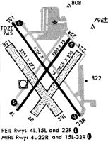
Runways
Runway Summary
| Runways: | 04L/22R 04R/22L 15L/33R 15R/33L |
| Longest Runway: | 15L/33R is 4107 ft (1252 m) long |
| Runways with an Instrument Approach: | 15L |
MWC Airport Runway Details
| Runway 04L/22R | 3203 ft x 75 ft (976 m x 23 m) | |
| Runway Length Source: | 3RD PARTY SURVEY as of 05/15/2021 | |
| Surface: | Asphalt - Excellent condition - No special surface treatment | |
| Runway Edge Lights: | Medium Intensity | |
Runway Weight Bearing Capacity (in thousands of pounds) |
||
| Single Wheel Landing Gear: | 30.0 | |
Runway 04L |
Runway 22R |
|
Elevation: |
737.2 | 738.4 |
Latitude: |
43-06-25.5624N | 43-06-51.0932N |
Longitude: |
088-02-17.2353W | 088-01-51.7480W |
|
Runway True Alignment: |
036 | 216 |
Glide Path Angle: |
4.0 degrees | 4.0 degrees |
Traffic Pattern: |
Left | Left |
Runway Markings Type: |
Nonprecision Instrument | Nonprecision Instrument |
Runway Markings Condition: |
Good | Good |
Object at End: |
TREE | |
Object Height: |
29 | |
Distance from End: |
700 | |
Object Centerline Offset: |
250 ft. left of centerline | |
Visual Glide Slope Indicators: |
4-Box VASI On Left Side Of Runway | 4-Box VASI On Left Side Of Runway |
REIL: |
Yes | Yes |
Touchdown Lights: |
No | No |
Centerline Lights: |
No | No |
Threshold Crossing Height: |
44 | 45 |
| Runway 04R/22L | 2840 ft x 270 ft (866 m x 82 m) | |
| Runway Length Source: | 3RD PARTY SURVEY as of 05/15/2021 | |
| Surface: | Asphalt - Excellent condition - No special surface treatment | |
Runway 04R |
Runway 22L |
|
Elevation: |
732.0 | 736.4 |
Latitude: |
43-06-22.9846N | 43-06-45.6257N |
Longitude: |
088-02-09.7634W | 088-01-47.1692W |
|
Runway True Alignment: |
036 | 216 |
Glide Path Angle: |
0.0 degrees | 0.0 degrees |
Traffic Pattern: |
Left | Left |
Object at End: |
TREES | TREES |
Object Height: |
50 | 53 |
Distance from End: |
915 | 800 |
Object Centerline Offset: |
250 ft. left of centerline | |
REIL: |
No | No |
Touchdown Lights: |
No | No |
Centerline Lights: |
No | No |
| Runway 15L/33R | 4107 ft x 75 ft (1252 m x 23 m) | |
| Runway Length Source: | 3RD PARTY SURVEY as of 05/15/2021 | |
| Surface: | Asphalt - Excellent condition - No special surface treatment | |
| Runway Edge Lights: | Medium Intensity | |
Runway Weight Bearing Capacity (in thousands of pounds) |
||
| Single Wheel Landing Gear: | 30.0 | |
Runway 15L |
Runway 33R |
|
Elevation: |
744.1 | 743.7 |
Latitude: |
43-06-56.9512N | 43-06-23.4945N |
Longitude: |
088-02-19.0456W | 088-01-47.7433W |
|
Runway True Alignment: |
146 | 326 |
ILS Type: |
LOCALIZER | |
Glide Path Angle: |
3.0 degrees | 4.0 degrees |
Traffic Pattern: |
Left | Left |
Runway Markings Type: |
Nonprecision Instrument | Nonprecision Instrument |
Runway Markings Condition: |
Good | Good |
Object at End: |
TREE | |
Object Height: |
35 | |
Distance from End: |
830 | |
Object Centerline Offset: |
250 ft. left of centerline | |
Visual Glide Slope Indicators: |
4-Light PAPI On Right Side Of Runway | 4-Light PAPI On Left Side Of Runway |
REIL: |
Yes | Yes |
Touchdown Lights: |
No | No |
Centerline Lights: |
No | No |
Threshold Crossing Height: |
41 | 40 |
| Runway 15R/33L | 3231 ft x 270 ft (985 m x 82 m) | |
| Runway Length Source: | 3RD PARTY SURVEY as of 05/15/2021 | |
| Surface: | Asphalt - Excellent condition - No special surface treatment | |
Runway 15R |
Runway 33L |
|
Elevation: |
742.3 | 733.3 |
Latitude: |
43-06-48.6445N | 43-06-22.3102N |
Longitude: |
088-02-21.0592W | 088-01-56.4539W |
|
Runway True Alignment: |
145 | 325 |
Glide Path Angle: |
0.0 degrees | 0.0 degrees |
Traffic Pattern: |
Left | Left |
Object at End: |
TREE | |
Object Height: |
50 | |
Distance from End: |
800 | |
Object Centerline Offset: |
250 ft. left of centerline | |
REIL: |
No | No |
Touchdown Lights: |
No | No |
Centerline Lights: |
No | No |
Services
Airframe Repair: |
Major |
Powerplant Repair: |
Major |
Bottled Oxygen: |
None |
Bulk Oxygen: |
None |
Fuel Available: |
100LL |
Landing Fees: |
No |
Parking: |
Tiedowns available |
Maps & Diagrams
MWC Sectional
Flight Planning
at skyvector.com
at skyvector.com