Location
Latitude: |
41-37-35.5000N (41.626528) |
Longitude: |
080-12-53.0000W (-80.214722) |
Elevation: |
1399.4 feet MSL (427 m MSL) |
Magnetic Variation: |
9.3 W (as of April 2024 from WMM2020 model) |
Time Zone: |
UTC -5.0 (Standard Time) UTC -4.0 (Daylight Savings Time) |
From City: |
03 N.M. W of Meadville, Pennsylvania |
Found On: |
Detroit Chart |
FAA Region: |
AEA |
Contacts
Manager: |
Publicly owned: |
| MICHAEL GOSS 16306 CORPORATE DR. MEADVILLE, PA 16335 814-720-2261 |
CCRAA 16306 CORPORATE DR. MEADVILLE, PA 16335 814-333-2677 |
Operations
Airport Status: |
Operational |
Facility Use: |
Public |
Type: |
Airport |
Activation Date: |
04/1938 |
Control tower: |
No |
Attendance (Months/Days/Hours): |
Months/Days/Hours ALL/ALL/0800-1700 |
Boundary ARTCC: |
ZOB (Cleveland) |
Responsible ARTCC: |
ZOB (Cleveland) |
Lighting Schedule: |
SEE RMK |
Segmented Circle Indicator: |
No |
Traffic Pattern Altitude (MSL): |
2399 feet (731 m) |
NOTAMs Facility: |
GKJ |
NOTAM-D Service: |
Yes |
International Airport of Entry: |
No |
Customs Landing Rights: |
No |
Military Landing Rights: |
Yes |
Civil/Military Joint Use: |
No |
Based Aircraft
| Single Engine: | 21 |
| Multi Engine: | 2 |
| Jet Engine: | 1 |
| GA Helicopters: | 1 |
Annual Operations (as of 07/02/2020)
| Total Operations: | 13369 | |
| Air Taxi: | 296 | 2.2% |
| GA Local: | 8912 | 66.7% |
| GA Itinerant: | 4056 | 30.3% |
| Military Aircraft: | 105 | 0.8% |
Communications
| CTAF: | 123.000 |
| Unicom: | 123.000 |
| Clearance Del.: | 124.95 124.95 124.95 |
| Approach: | YOUNGSTOWN CLEVELAND ARTCC |
| Departure: | YOUNGSTOWN CLEVELAND ARTCC |
| ASOS: | 121.425 (814-337-2590) |
- APCH/DEP SVC PRVDD BY CLEVELAND ARTCC (ZOB) ON FREQS 120.775/298.95 (CHARDON RCAG) WHEN YOUNGSTOWN APCH CTL CLSD.
Fixed Based Operators (FBOs) & Fuel
(Click on a business for detail)
Please help us keep this information up to date. This is a FREE SERVICE just like everything else on Airport Guide! If you see that a business needs to be added, modified, or deleted please fill out our Update Form.
To add, modify, or delete a business click here.
Please help us keep this information up to date. This is a FREE SERVICE just like everything else on Airport Guide! If you see that a business needs to be added, modified, or deleted please fill out our Update Form.
Area Code: 814 |
| Business Name | Frequency | Phone | Fuel Grade |
|---|
Flight Service Stations
| Primary | Alternate | |
| FSS on Field: | N | |
| FSS Name (ID): | Altoona(AOO) | |
| Frequency: | ||
| Toll Free Phone: | 1-800-WX-BRIEF |
Instrument Procedures / Charts
FAA Terminal Procedures valid from 0901Z 03/21/24 to 0901Z 04/18/24.
There are various types of charts available for an airport. They are listed in the Page Type column. Here is a legend for those types:
APD - Airport Diagram
DP - Departure Procedure Charts
HOT - Hot Spots
IAP - Instrument Approach Procedure Charts
MIN - Minimums
STAR - Standard Terminal Arrival Charts
| Page Type | Page Name | Volume | Action Since Last Cycle |
|---|---|---|---|
| IAP | LOC RWY 25 | NE-4 | Changed |
| IAP | RNAV (GPS) RWY 07 | NE-4 | Changed |
| IAP | RNAV (GPS) RWY 25 | NE-4 | Changed |
| MIN | ALTERNATE MINIMUMS | NE-4 | |
| MIN | TAKEOFF MINIMUMS | NE-4 |
Terminal Procedures are only available for airports in several countries with more being added all the time. If you are looking for a specific country's charts, please send an email to support(at)airportguide.com stating the country name. This will be used to prioritize the implementation.
Navigation Aids (Navaids) near MEJ
| Dist (NM) | ID | Morse Code | Name | Type | Freq | True Hdg | Mag Hdg |
|---|---|---|---|---|---|---|---|
| 19.6 | FKL | . . _ . _ . _ . _ . . | Franklin | VOR | 109.60 | 124 | 133 |
| 23.7 | ERI | . . _ . . . | Erie | TACAN | 109.40 | 351 | 360 |
| 24.8 | ERI | . . _ . . . | Esmer | NDB | 349 | 355 | 364 |
| 25.2 | JFN | . _ _ _ . . _ . _ . | Jefferson | DME | 115.2 | 288 | 297 |
| 27.2 | YNG | _ . _ _ _ . _ _ . | Youngstown | VORTAC | 109.00 | 229 | 238 |
| 30.0 | CQD | _ . _ . _ _ . _ _ . . | Cascade | NDB | 372 | 9 | 18 |
| 30.6 | ORJ | _ _ _ . _ . . _ _ _ | Corry | NDB | 258 | 55 | 65 |
| 30.8 | YN | _ . _ _ _ . | Fetch | NDB | 338 | 214 | 223 |
| 31.8 | HBD | . . . . _ . . . _ . . | Hubbard | NDB | 408 | 206 | 215 |
| 36.1 | TDT | _ _ . . _ | Tidioute | DME | 117.6 | 81 | 91 |
| 37.3 | UCP | . . _ _ . _ . . _ _ . | Castle | NDB | 272 | 194 | 203 |
| 43.1 | CXR | _ . _ . _ . . _ . _ . | Chardon | VOR-DME | 112.70 | 261 | 270 |
| 44.6 | CIP | _ . _ . . . . _ _ . | Clarion | DME | 112.9 | 129 | 139 |
| 48.1 | EWC | . . _ _ _ . _ . | Ellwood City | VOR-DME | 115.80 | 179 | 188 |
| 52.3 | LQL | . _ . . _ _ . _ . _ . . | Lakeland | NDB | 263 | 274 | 283 |
| 54.2 | ACO | . _ _ . _ . _ _ _ | Akron | VOR-DME | 114.40 | 235 | 244 |
| 59.3 | JHW | . _ _ _ . . . . . _ _ | Jamestown | VOR-DME | 114.70 | 55 | 65 |
| 62.5 | AK | . _ _ . _ | Akron | NDB | 362 | 238 | 247 |
| 66.7 | DKK | _ . . _ . _ _ . _ | Dunkirk | DME | 116.2 | 38 | 48 |
| 68.3 | MMJ | _ _ _ _ . _ _ _ | Montour | DME | 112 | 179 | 188 |
Nearby Airports with Fuel
Notices to Airmen (NOTAMS)
Remarks
| A11 | CRAWFORD COUNTY REGIONAL AIRPORT AUTHORITY |
| A110-1 | BIRDS, DEER, & GND HOGS ON & INVOF ARPT. |
| A110-3 | TRML BLDG CLSD MAJOR HOLIDAYS & WKENDS. CALL AHD TO COORD SER. |
| A110-4 | FOR CD CTC YOUNGSTOWN APCH AT 330-856-4806, WHEN APCH CLSD CTC CLEVELAND ARTCC AT 440-774-0232. |
| A110-5 | DURING WINTER MONTHS RWY & AFLD PAVEMENTS MAY NOT BE MNTND, CALL FOR FLD COND. |
| A16 | (814) 720-2261. |
| A24 | LANDING FEES VARY, CALL AIRPORT AT 814-333-2677 FOR FEE AMOUNTS. |
| A70-FUEL-A | JET A ANTI-ICE AVAILABLE UPON REQUEST. |
| A75 | TIE DOWN ROPES ARE NOT SUPPLIED |
| A81-APT | ACTVT MALS RWY 25; PAPI RWY 25; VASI RWY 07; MIRL RWY 07/25 - CTAF. |
| E111 | IN OPERN PRIOR TO 1959. |
Runways
Runway Summary
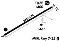
| Runways: | 07/25 |
| Longest Runway: | 07/25 is 5001 ft (1524 m) long |
| Runways with an Instrument Approach: | 25 |
MEJ Airport Runway Details
| Runway 07/25 | 5001 ft x 75 ft (1524 m x 23 m) | |
| Runway Length Source: | 3RD PARTY SURVEY as of 08/16/2009 | |
| Surface: | Asphalt - Good condition - No special surface treatment | |
| Runway Edge Lights: | Medium Intensity | |
Runway Weight Bearing Capacity (in thousands of pounds) |
||
| Single Wheel Landing Gear: | 12.0 | |
| Dual Wheel Landing Gear: | 60.0 | |
Runway 07 |
Runway 25 |
|
Elevation: |
1392.4 | 1396.6 |
Latitude: |
41-37-23.5566N | 41-37-47.3442N |
Longitude: |
080-13-21.8877W | 080-12-24.1850W |
|
Runway True Alignment: |
061 | 241 |
ILS Type: |
LOCALIZER | |
Glide Path Angle: |
3.0 degrees | 3.0 degrees |
Traffic Pattern: |
Left | Left |
Runway Markings Type: |
Nonprecision Instrument | Nonprecision Instrument |
Runway Markings Condition: |
Good | Good |
Object at End: |
TREES | |
Object Height: |
23 | |
Distance from End: |
473 | |
Object Centerline Offset: |
272 ft. left of centerline | |
Visual Glide Slope Indicators: |
4-Box VASI On Left Side Of Runway | 4-Light PAPI On Left Side Of Runway |
Approach Light System: |
1,400 Foot Medium Intensity Approach Lighting System | |
Threshold Crossing Height: |
58 | 41 |
Services
Airframe Repair: |
None |
Powerplant Repair: |
None |
Bottled Oxygen: |
None |
Bulk Oxygen: |
None |
Fuel Available: |
100LL |
Landing Fees: |
No |
Parking: |
Tiedowns available |
Other Services: |
Parachute rental |
Maps & Diagrams
MEJ Sectional
Flight Planning
at skyvector.com
at skyvector.com