Location
Latitude: |
32-02-11.6536N (32.03657) |
Longitude: |
102-06-05.4992W (-102.101528) |
Elevation: |
2805.4 feet MSL (855 m MSL) |
Magnetic Variation: |
5.6 E (as of April 2024 from WMM2020 model) |
Time Zone: |
UTC -6.0 (Standard Time) UTC -5.0 (Daylight Savings Time) |
From City: |
03 N.M. N of Midland, Texas |
Found On: |
Albuquerque Chart |
FAA Region: |
ASW |
Contacts
Manager: |
Publicly owned: |
| JUSTINE RUFF PO BOX 60305 MIDLAND, TX 79711 432-560-2200 |
CITY OF MIDLAND PO BOX 60305 A.T.S. MIDLAND, TX 79711 432-560-2200 |
Operations
Airport Status: |
Operational |
Facility Use: |
Public |
Type: |
Airport |
Activation Date: |
02/1943 |
Control tower: |
No |
Attendance (Months/Days/Hours): |
Months/Days/Hours ALL/ALL/0600-2000 |
Boundary ARTCC: |
ZFW (Fort Worth) |
Responsible ARTCC: |
ZFW (Fort Worth) |
Lighting Schedule: |
SEE RMK |
Segmented Circle Indicator: |
Yes |
Traffic Pattern Altitude (MSL): |
3805 feet (1160 m) |
NOTAMs Facility: |
MDD |
NOTAM-D Service: |
Yes |
International Airport of Entry: |
No |
Customs Landing Rights: |
No |
Military Landing Rights: |
Yes |
Civil/Military Joint Use: |
No |
Based Aircraft
| Single Engine: | 69 |
| Multi Engine: | 7 |
| Jet Engine: | 9 |
| GA Helicopters: | 6 |
Annual Operations (as of 01/04/2018)
| Total Operations: | 41010 | |
| Air Taxi: | 2000 | 4.9% |
| GA Local: | 26000 | 63.4% |
| GA Itinerant: | 13000 | 31.7% |
| Military Aircraft: | 10 | 0.0% |
Communications
| CTAF: | 122.700 |
| Unicom: | 122.700 |
| Clearance Del.: | 121.8 121.8 121.8 |
| Approach: | MIDLAND FORT WORTH ARTCC |
| Departure: | MIDLAND FORT WORTH ARTCC |
| AWOS-3: | 118.125 (432-687-4605) |
- APCH/DEP CTL SVC PRVDD BY FORT WORTH ARTCC (ZFW) ON FREQS 133.1/298.95 (MIDLAND/A RCAG) WHEN MIDLAND APCH CTL (MAF) CLSD.
Fixed Based Operators (FBOs) & Fuel
(Click on a business for detail)
Please help us keep this information up to date. This is a FREE SERVICE just like everything else on Airport Guide! If you see that a business needs to be added, modified, or deleted please fill out our Update Form.
To add, modify, or delete a business click here.
Please help us keep this information up to date. This is a FREE SERVICE just like everything else on Airport Guide! If you see that a business needs to be added, modified, or deleted please fill out our Update Form.
Area Code: 915 |
| Business Name | Frequency | Phone | Fuel Grade |
|---|---|---|---|
| Basin Aviation
Update FBO info |
Unicom 122.7 | 685-7000, 800-749-7015 | 100LL, Jet A |
Flight Service Stations
| Primary | Alternate | |
| FSS on Field: | N | |
| FSS Name (ID): | San Angelo(SJT) | |
| Frequency: | ||
| Toll Free Phone: | 1-800-WX-BRIEF |
Instrument Procedures / Charts
FAA Terminal Procedures valid from 0901Z 03/21/24 to 0901Z 04/18/24.
There are various types of charts available for an airport. They are listed in the Page Type column. Here is a legend for those types:
APD - Airport Diagram
DP - Departure Procedure Charts
HOT - Hot Spots
IAP - Instrument Approach Procedure Charts
MIN - Minimums
STAR - Standard Terminal Arrival Charts
| Page Type | Page Name | Volume | Action Since Last Cycle |
|---|---|---|---|
| IAP | RNAV (GPS) RWY 25 | SC-3 | |
| IAP | RNAV (GPS) RWY 34 | SC-3 | |
| IAP | VOR RWY 25 | SC-3 | |
| IAP | VOR-A | SC-3 | |
| MIN | ALTERNATE MINIMUMS | SC-3 | |
| MIN | TAKEOFF MINIMUMS | SC-3 |
Terminal Procedures are only available for airports in several countries with more being added all the time. If you are looking for a specific country's charts, please send an email to support(at)airportguide.com stating the country name. This will be used to prioritize the implementation.
Navigation Aids (Navaids) near MDD
| Dist (NM) | ID | Morse Code | Name | Type | Freq | True Hdg | Mag Hdg |
|---|---|---|---|---|---|---|---|
| 4.8 | MAF | _ _ . _ . . _ . | Midland | VORTAC | 114.80 | 250 | 244 |
| 7.7 | MAF | _ _ . _ . . _ . | Midland | VOT | 108.20 | 221 | 215 |
| 11.7 | MA | _ _ . _ | Farly | NDB | 326 | 255 | 249 |
| 37.7 | BGS | _ . . . _ _ . . . . | Big Spring | VORTAC | 117.20 | 56 | 51 |
| 44.3 | LSA | . _ . . . . . . _ | Lamesa | NDB | 338 | 12 | 6 |
| 47.0 | GNC | _ _ . _ . _ . _ . | Gaines County | NDB | 344 | 324 | 318 |
| 59.0 | INK | . . _ . _ . _ | Wink | VORTAC | 112.10 | 260 | 254 |
| 69.3 | HOB | . . . . _ _ _ _ . . . | Hobbs | VORTAC | 111.00 | 301 | 295 |
| 70.8 | SDR | . . . _ . . . _ . | Snyder | NDB | 359 | 55 | 50 |
| 79.0 | FST | . . _ . . . . _ | Fort Stockton | VORTAC | 116.90 | 214 | 208 |
| 82.5 | PEQ | . _ _ . . _ _ . _ | Pecos | VOR-DME | 116.50 | 246 | 240 |
| 86.8 | SWW | . . . . _ _ . _ _ | Sweetwater | NDB | 275 | 72 | 67 |
| 90.2 | SJ | . . . . _ _ _ | Woole | NDB | 356 | 119 | 114 |
| 92.2 | LLN | . _ . . . _ . . _ . | Levelland | NDB | 266 | 351 | 345 |
| 93.0 | SJT | . . . . _ _ _ _ | San Angelo | VORTAC | 115.10 | 114 | 109 |
| 99.4 | LD | . _ . . _ . . | Lubbi | NDB | 272 | 10 | 4 |
Nearby Airports with Fuel
Notices to Airmen (NOTAMS)
Remarks
| A110*G | THIS AIRPORT HAS BEEN SURVEYED BY THE NATIONAL GEODETIC SURVEY. |
| A110-2 | BIRDS INVOF ARPT (SEASONAL). |
| A110-3 | FOR CD WHEN 121.8 IS OTS CTC MIDLAND APCH AT 432-563-2123. WHEN APCH CLSD CTC FORT WORTH ARTCC AT 817-858-7584. |
| A110-4 | OPRS ON NON-PAVED SURFACES ARE PROHIBITED WITHOUT 24 HR PPR. |
| A70-FUEL-10 | 0LL FOR FUEL AFT HRS, CALL 432-352-9011 DURG BUS HRS TO SCHED APPOINTMENT. |
| A81-APT | MIRL RWYS 07/25 & 16/34 PRESET LOW INTST; TO INCR INTST & ACTVT VASI RWY 25; PAPI RWYS 07, 16 & 34 - CTAF. |
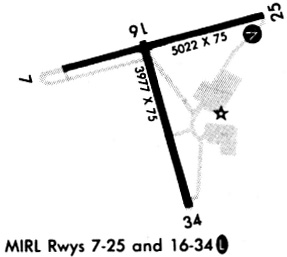
Runways
Runway Summary
| Runways: | 07/25 16/34 |
| Longest Runway: | 07/25 is 5571 ft (1698 m) long |
| Runways with an Instrument Approach: |
MDD Airport Runway Details
| Runway 07/25 | 5571 ft x 75 ft (1698 m x 23 m) | |
| Runway Length Source: | NGS as of 01/19/2009 | |
| Surface: | Asphalt - Good condition - Rubberized friction seal coat | |
| Runway Edge Lights: | Medium Intensity | |
Runway Weight Bearing Capacity (in thousands of pounds) |
||
| Single Wheel Landing Gear: | 18.5 | |
Runway 07 |
Runway 25 |
|
Elevation: |
2803.4 | 2789.9 |
Latitude: |
32-02-13.0300N | 32-02-27.3293N |
Longitude: |
102-06-38.1400W | 102-05-35.6380W |
|
Runway True Alignment: |
075 | 255 |
Glide Path Angle: |
3.0 degrees | 3.0 degrees |
Traffic Pattern: |
Left | Right |
Runway Markings Type: |
Basic | Nonprecision Instrument |
Runway Markings Condition: |
Good | Good |
Object at End: |
POLE | POLE |
Object Height: |
33 | 53 |
Distance from End: |
705 | 2010 |
Object Centerline Offset: |
0 ft. left and right of centerline | 480 ft. right of centerline |
Visual Glide Slope Indicators: |
2-Light PAPI On Left Side Of Runway | 4-Box VASI On Left Side Of Runway |
Threshold Crossing Height: |
40 | 53 |
Threshold Elevation: |
2803.4 | |
Displaced Threshold: |
550 | |
Threshold Latitude: |
32-02-14.4400N | |
Threshold Longitude: |
102-06-31.9700W | |
Declared Distances |
||
Take Off Run Avbl. (TORA): |
5571 | |
Take Off Distance Avbl. (TODA): |
5571 | |
Actual Stop Dist. Avbl. (ASDA): |
5571 | |
Landing Dist. Avbl. (LDA): |
5022 | |
| Runway 16/34 | 3977 ft x 75 ft (1212 m x 23 m) | |
| Runway Length Source: | NGS as of 01/19/2009 | |
| Surface: | Asphalt - Good condition - No special surface treatment | |
| Runway Edge Lights: | Medium Intensity | |
Runway Weight Bearing Capacity (in thousands of pounds) |
||
| Single Wheel Landing Gear: | 18.5 | |
Runway 16 |
Runway 34 |
|
Elevation: |
2799.8 | 2796.6 |
Latitude: |
32-02-18.7106N | 32-01-40.7098N |
Longitude: |
102-06-09.5552W | 102-05-57.5494W |
|
Runway True Alignment: |
165 | 345 |
Glide Path Angle: |
3.0 degrees | 3.0 degrees |
Traffic Pattern: |
Left | Right |
Runway Markings Type: |
Basic | Nonprecision Instrument |
Runway Markings Condition: |
Good | Good |
Object at End: |
ROAD | TREES |
Object Height: |
15 | 38 |
Distance from End: |
495 | 840 |
Object Centerline Offset: |
0 ft. left and right of centerline | 480 ft. right of centerline |
Visual Glide Slope Indicators: |
2-Light PAPI On Left Side Of Runway | 2-Light PAPI On Left Side Of Runway |
Threshold Crossing Height: |
40 | 40 |
Services
Airframe Repair: |
Major |
Powerplant Repair: |
Major |
Fuel Available: |
100LL, Jet A |
Landing Fees: |
No |
Parking: |
Tiedowns available |
Maps & Diagrams
MDD Sectional
Flight Planning
at skyvector.com
at skyvector.com