Location
Latitude: |
33-46-35.0100N (33.776392) |
Longitude: |
090-31-30.0300W (-90.525008) |
Elevation: |
137.0 feet MSL (42 m MSL) |
Magnetic Variation: |
1.4 W (as of April 2024 from WMM2020 model) |
Time Zone: |
UTC -6.0 (Standard Time) UTC -5.0 (Daylight Savings Time) |
From City: |
02 N.M. S of Drew, Mississippi |
Found On: |
Memphis Chart |
FAA Region: |
ASO |
Contacts
Manager: |
Publicly owned: |
| BUDDY WEEKS 4141 HWY 49 W DREW, MS 38737 662-745-2733 |
TOWN OF RULEVILLE AND DREW 130 SHAW AVE DREW, MS 38737 662-745-8556 |
Operations
Airport Status: |
Operational |
Facility Use: |
Public |
Type: |
Airport |
Activation Date: |
10/1970 |
Control tower: |
No |
Attendance (Months/Days/Hours): |
Months/Days/Hours IREG |
Boundary ARTCC: |
ZME (Memphis) |
Responsible ARTCC: |
ZME (Memphis) |
Lighting Schedule: |
SEE RMK |
Segmented Circle Indicator: |
Yes |
Traffic Pattern Altitude (MSL): |
1137 feet (347 m) |
NOTAMs Facility: |
GWO |
NOTAM-D Service: |
Yes |
International Airport of Entry: |
No |
Customs Landing Rights: |
No |
Military Landing Rights: |
Yes |
Civil/Military Joint Use: |
No |
Based Aircraft
| Single Engine: | 11 |
Annual Operations (as of 10/27/2023)
| Total Operations: | 105400 | |
| GA Local: | 102300 | 97.1% |
| GA Itinerant: | 3100 | 2.9% |
Communications
| CTAF: | 122.900 |
- APCH/DEP SVC PRVDD BY MEMPHIS ARTCC ON FREQS 135.875/269.35 (GREENVILLE RCAG & PINE BLUFF RCAG).
Fixed Based Operators (FBOs) & Fuel
(Click on a business for detail)
Please help us keep this information up to date. This is a FREE SERVICE just like everything else on Airport Guide! If you see that a business needs to be added, modified, or deleted please fill out our Update Form.
To add, modify, or delete a business click here.
Please help us keep this information up to date. This is a FREE SERVICE just like everything else on Airport Guide! If you see that a business needs to be added, modified, or deleted please fill out our Update Form.
Area Code: 662 |
| Business Name | Frequency | Phone | Fuel Grade |
|---|
Flight Service Stations
| Primary | Alternate | |
| FSS on Field: | N | |
| FSS Name (ID): | Greenwood(GWO) | |
| Frequency: | ||
| Toll Free Phone: | 1-800-WX-BRIEF |
Instrument Procedures / Charts
FAA Terminal Procedures valid from 0901Z 03/21/24 to 0901Z 04/18/24.
There are various types of charts available for an airport. They are listed in the Page Type column. Here is a legend for those types:
APD - Airport Diagram
DP - Departure Procedure Charts
HOT - Hot Spots
IAP - Instrument Approach Procedure Charts
MIN - Minimums
STAR - Standard Terminal Arrival Charts
| Page Type | Page Name | Volume | Action Since Last Cycle |
|---|---|---|---|
| IAP | RNAV (GPS) RWY 18 | SC-4 | |
| IAP | RNAV (GPS) RWY 36 | SC-4 | |
| IAP | VOR-A | SC-4 | |
| MIN | TAKEOFF MINIMUMS | SC-4 |
Terminal Procedures are only available for airports in several countries with more being added all the time. If you are looking for a specific country's charts, please send an email to support(at)airportguide.com stating the country name. This will be used to prioritize the implementation.
Navigation Aids (Navaids) near M37
| Dist (NM) | ID | Morse Code | Name | Type | Freq | True Hdg | Mag Hdg |
|---|---|---|---|---|---|---|---|
| 22.5 | SQS | . . . _ _ . _ . . . | Sidon | VORTAC | 114.70 | 146 | 147 |
| 24.6 | GW | _ _ . . _ _ | Teock | NDB | 349 | 116 | 118 |
| 27.4 | GLH | _ _ . . _ . . . . . . | Greenville | VOR-DME | 114.25 | 236 | 237 |
| 31.1 | MTQ | _ _ _ _ _ . _ | Metcalf | NDB | 359 | 227 | 228 |
| 33.1 | SBQ | . . . _ . . . _ _ . _ | Scobey | NDB | 245 | 77 | 79 |
| 48.5 | UJM | . . _ . _ _ _ _ _ | Marvell | VOR-DME | 109.60 | 351 | 352 |
| 57.7 | UV | . . _ . . . _ | Tunng | NDB | 426 | 50 | 52 |
| 60.8 | MON | _ _ _ _ _ _ . | Monticello | DME | 111.6 | 258 | 259 |
| 65.8 | BLE | _ . . . . _ . . . | Lake Providence | NDB | 278 | 210 | 211 |
| 68.3 | TT | _ _ | Stutt | NDB | 338 | 310 | 311 |
| 75.0 | SGT | . . . _ _ . _ | Stuttgart | NDB | 269 | 315 | 316 |
| 75.2 | PBF | . _ _ . _ . . . . . _ . | Pine Bluff | VOR-DME | 116.00 | 292 | 293 |
| 78.2 | JAN | . _ _ _ . _ _ . | Jackson | VORTAC | 112.60 | 166 | 167 |
| 78.5 | HLI | . . . . . _ . . . . | Holly Springs | VORTAC | 112.40 | 40 | 42 |
| 79.0 | MEM | _ _ . _ _ | Memphis | VORTAC | 117.50 | 19 | 21 |
| 80.3 | ME | _ _ . | Elvis | NDB | 287 | 16 | 18 |
| 81.0 | MEM | _ _ . _ _ | Memphis Metropolitn | VOT | 111.00 | 19 | 21 |
| 82.9 | JH | . _ _ _ . . . . | Brenz | NDB | 260 | 170 | 171 |
| 83.3 | MHZ | _ _ . . . . _ _ . . | Magnolia | VORTAC | 113.20 | 165 | 167 |
| 84.3 | JA | . _ _ _ . _ | Allen | NDB | 365 | 165 | 167 |
Nearby Airports with Fuel
Notices to Airmen (NOTAMS)
Remarks
| A110*G | THIS AIRPORT HAS BEEN SURVEYED BY THE NATIONAL GEODETIC SURVEY. |
| A110-1 | FOR CD CTC MEMPHIS ARTCC AT 901-368-8453/8449. |
| A14 | MELANIE TOWNSEND-BLACKMAN, MAYOR OF DREW 662-745-8556. |
| A75 | PILOTS MUST PRVD THEIR OWN TIEDOWN ROPES. |
| A80 | OTS INDEF. |
| A81-APT | MIRL RWY 18/36 OPRS DUSK-2200; AFT 2200 ACTVT - CTAF. PAPI RWY 18 & 36 OPR CONSLY. |
Runways
Runway Summary
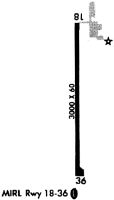
| Runways: | 18/36 |
| Longest Runway: | 18/36 is 3000 ft (914 m) long |
| Runways with an Instrument Approach: |
M37 Airport Runway Details
| Runway 18/36 | 3000 ft x 60 ft (914 m x 18 m) | |
| Surface: | Asphalt - Good condition - No special surface treatment | |
| Runway Edge Lights: | Medium Intensity | |
Runway Weight Bearing Capacity (in thousands of pounds) |
||
| Single Wheel Landing Gear: | 16.0 | |
Runway 18 |
Runway 36 |
|
Elevation: |
137.0 | 133.0 |
Latitude: |
33-46-49.8450N | 33-46-20.1710N |
Longitude: |
090-31-29.8700W | 090-31-30.1560W |
|
Runway True Alignment: |
180 | 000 |
Glide Path Angle: |
3.0 degrees | 3.0 degrees |
Runway Markings Type: |
Nonprecision Instrument | Nonprecision Instrument |
Runway Markings Condition: |
Good | Good |
Visual Glide Slope Indicators: |
2-Light PAPI On Left Side Of Runway | 2-Light PAPI On Left Side Of Runway |
Threshold Crossing Height: |
40 | 40 |
Services
Airframe Repair: |
None |
Powerplant Repair: |
None |
Bottled Oxygen: |
None |
Bulk Oxygen: |
None |
Fuel Available: |
100LL |
Landing Fees: |
No |
Parking: |
Tiedowns available |
Maps & Diagrams
M37 Sectional
Flight Planning
at skyvector.com
at skyvector.com