Location
Latitude: |
35-52-46.8700N (35.879686) |
Longitude: |
106-16-07.2700W (-106.268686) |
Elevation: |
7170.9 feet MSL (2186 m MSL) |
Magnetic Variation: |
7.9 E (as of April 2024 from WMM2020 model) |
Time Zone: |
UTC -7.0 (Standard Time) UTC -6.0 (Daylight Savings Time) |
From City: |
01 N.M. E of Los Alamos, New Mexico |
Found On: |
Denver Chart |
FAA Region: |
ASW |
Contacts
Manager: |
Publicly owned: |
| BOBBI HUSEMAN 1040 AIRPORT RD LOS ALAMOS, NM 87544 505-709-8687 |
COUNTY OF LOS ALAMOS 1000 CENTRAL AVE SUITE 350 LOS ALAMOS, NM 87544 505-663-1750 |
Operations
Airport Status: |
Operational |
Facility Use: |
Public |
Type: |
Airport |
Activation Date: |
04/1963 |
Control tower: |
No |
Attendance (Months/Days/Hours): |
Months/Days/Hours ALL/MON-FRI/0800-1700 |
Boundary ARTCC: |
ZAB (Albuquerque) |
Responsible ARTCC: |
ZAB (Albuquerque) |
Lighting Schedule: |
SEE RMK |
Segmented Circle Indicator: |
Yes |
Traffic Pattern Altitude (MSL): |
8171 feet (2491 m) |
NOTAMs Facility: |
LAM |
NOTAM-D Service: |
Yes |
Based Aircraft
| Single Engine: | 45 |
| GA Helicopters: | 1 |
Annual Operations (as of 04/26/2022)
| Total Operations: | 13640 | |
| Air Taxi: | 60 | 0.4% |
| GA Local: | 11230 | 82.3% |
| GA Itinerant: | 2300 | 16.9% |
| Military Aircraft: | 50 | 0.4% |
Communications
| CTAF: | 123.000 |
| Unicom: | 123.000 |
| AWOS-3: | 124.175 (505-662-8423) |
- APCH/DEP SVC PRVDD BY ALBUQUERQUE ARTCC (ZAB) ON FREQS 132.8/346.35 (TESUQUE PEAK RCAG).
Fixed Based Operators (FBOs) & Fuel
(Click on a business for detail)
Please help us keep this information up to date. This is a FREE SERVICE just like everything else on Airport Guide! If you see that a business needs to be added, modified, or deleted please fill out our Update Form.
To add, modify, or delete a business click here.
Please help us keep this information up to date. This is a FREE SERVICE just like everything else on Airport Guide! If you see that a business needs to be added, modified, or deleted please fill out our Update Form.
Area Code: 505 |
| Business Name | Frequency | Phone | Fuel Grade |
|---|---|---|---|
| Airport Management
Update FBO info |
662-8420 | 100LL | |
| Coyote Aviation
Update FBO info |
662-2115 |
Flight Service Stations
| Primary | Alternate | |
| FSS on Field: | N | |
| FSS Name (ID): | Albuquerque(ABQ) | |
| Frequency: | ||
| Toll Free Phone: | 1-800-WX-BRIEF |
Instrument Procedures / Charts
FAA Terminal Procedures valid from 0901Z 03/21/24 to 0901Z 04/18/24.
There are various types of charts available for an airport. They are listed in the Page Type column. Here is a legend for those types:
APD - Airport Diagram
DP - Departure Procedure Charts
HOT - Hot Spots
IAP - Instrument Approach Procedure Charts
MIN - Minimums
STAR - Standard Terminal Arrival Charts
| Page Type | Page Name | Volume | Action Since Last Cycle |
|---|---|---|---|
| IAP | RNAV (GPS) Y RWY 27 | SW-1 | Changed |
| IAP | RNAV (GPS) Z RWY 27 | SW-1 | Changed |
| MIN | ALTERNATE MINIMUMS | SW-1 | |
| MIN | TAKEOFF MINIMUMS | SW-1 |
Terminal Procedures are only available for airports in several countries with more being added all the time. If you are looking for a specific country's charts, please send an email to support(at)airportguide.com stating the country name. This will be used to prioritize the implementation.
Navigation Aids (Navaids) near LAM
| Dist (NM) | ID | Morse Code | Name | Type | Freq | True Hdg | Mag Hdg |
|---|---|---|---|---|---|---|---|
| 20.4 | SG | . . . _ _ . | Doman | NDB | 341 | 162 | 154 |
| 22.6 | SAF | . . . . _ . . _ . | Santa Fe | VORTAC | 110.60 | 153 | 145 |
| 45.3 | AE | . _ . | Dudle | NDB | 351 | 208 | 200 |
| 47.1 | TAS | _ . _ . . . | Taos | VORTAC | 115.80 | 21 | 13 |
| 51.1 | OTO | _ _ _ _ _ _ _ | Otto | VOR | 114.00 | 161 | 153 |
| 53.1 | ABQ | . _ _ . . . _ _ . _ | Albuquerque | VOT | 111.00 | 198 | 190 |
| 56.7 | FTI | . . _ . _ . . | Fort Union | VORTAC | 117.30 | 103 | 95 |
| 56.8 | ABQ | . _ _ . . . _ _ . _ | Albuquerque | VORTAC | 113.20 | 208 | 200 |
| 75.7 | ACH | . _ _ . _ . . . . . | Anton Chico | VORTAC | 117.80 | 127 | 119 |
| 77.0 | CIM | _ . _ . . . _ _ | Cimarron | VORTAC | 116.40 | 61 | 53 |
| 78.8 | BRG | _ . . . . _ . _ _ . | Belen | DME | 114.75 | 200 | 192 |
| 90.8 | ALS | . _ . _ . . . . . | Alamosa | VORTAC | 113.90 | 13 | 5 |
| 95.3 | CNX | _ . _ . _ . _ . . _ | Corona | VORTAC | 115.50 | 162 | 154 |
| 96.3 | ONM | _ _ _ _ . _ _ | Socorro | VORTAC | 116.80 | 196 | 188 |
Nearby Airports with Fuel
Notices to Airmen (NOTAMS)
Remarks
| A110-12 | WILDLIFE ON & INVOF ARPT. |
| A110-13 | ARFF INDEX B AVBL; 24 HR PPR. |
| A110-15 | FOR CD CTC ALBUQUERQUE ARTCC AT 505-856-4861. |
| A110-2 | RADIO COMM REQ BFR ENTERING TFC PAT; STRONG GUSTY CROSSWINDS. TGL NA. |
| A110-9 | RSTRD AREA ADJ TO S SIDE OF ARPT. |
| A17 | CLOSED HOL; AFT HRS - 505-709-8687. |
| A30-09/27 | LND W; TKOF E. |
| A30A-27 | VFR TFC RMN 5 MI E OF ARPT TIL TURNING FINAL; R TURN ON GO AROUND OR MISSED APCH. |
| A58-09 | +8 FT BLAST BARRIER 75 FT FM THR 50 FT L & R OF CNTRLN; +25 FT LIGHT POLE 198 FT FM THR 135 FT L OF CNTRLN; +4-15 FT BRUSH & TREES 80-200 FT FM THR 125 FT L & R OF CNTRLN. |
| A70-FUEL-10 | 0LL SELF SERV H24 WITH CREDIT CARD. |
| A81-APT | ACTVT REILS RWY 27; MIRL RWY 09/27 - CTAF. |
| E111 | PRVDD APCH SLOPES TO RWY ENDS AT LEAST 20:1 & EXCEPTIONS TO THE ONE WAY OPNS ARE PRVDD IN THE CASE OF ADVERSE TAIL WINDS WHICH WOULD EXCEED A GIVEN ACFT'S TAIL WIND LIMITATIONS. |
| E40-27 | 1.5 UP TO W. |
Runways
Runway Summary
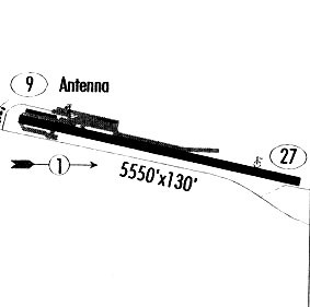
| Runways: | 09/27 |
| Longest Runway: | 09/27 is 6000 ft (1829 m) long |
| Runways with an Instrument Approach: |
LAM Airport Runway Details
| Runway 09/27 | 6000 ft x 120 ft (1829 m x 37 m) | |
| Runway Length Source: | AVN as of 08/23/2011 | |
| Surface: | Asphalt - Good condition - Saw-cut or plastic grooved | |
| Runway Pavement Class: | 35 /F/C/X/T | |
| Runway Edge Lights: | Medium Intensity | |
Runway Weight Bearing Capacity (in thousands of pounds) |
||
| Single Wheel Landing Gear: | 43.0 | |
Runway 09 |
Runway 27 |
|
Elevation: |
7170.9 | 7079.6 |
Latitude: |
35-52-53.2370N | 35-52-40.4920N |
Longitude: |
106-16-42.8810W | 106-15-31.6670W |
|
Runway True Alignment: |
102 | 282 |
Glide Path Angle: |
0.0 degrees | 3.0 degrees |
Traffic Pattern: |
Left | Right |
Runway Markings Type: |
Basic | Nonprecision Instrument |
Runway Markings Condition: |
Fair | Fair |
Object at End: |
FENCE | |
Object Height: |
8 | |
Distance from End: |
201 | |
Object Centerline Offset: |
145 ft. left of centerline | |
Visual Glide Slope Indicators: |
2-Light PAPI On Left Side Of Runway | |
REIL: |
Yes | |
Threshold Crossing Height: |
45 |
Services
Airframe Repair: |
Minor |
Powerplant Repair: |
Minor |
Bottled Oxygen: |
High Pressure / Low Pressure |
Fuel Available: |
100LL, Jet A-1+ |
Landing Fees: |
No |
Parking: |
Hangars and tiedowns available |
Maps & Diagrams
LAM Sectional
Flight Planning
at skyvector.com
at skyvector.com