Location
Latitude: |
35-10-12.8870N (35.170246) |
Longitude: |
088-13-00.2140W (-88.216726) |
Elevation: |
472.7 feet MSL (144 m MSL) |
Magnetic Variation: |
3.1 W (as of April 2024 from WMM2020 model) |
Time Zone: |
UTC -6.0 (Standard Time) UTC -5.0 (Daylight Savings Time) |
From City: |
03 N.M. SE of Savannah, Tennessee |
Found On: |
Memphis Chart |
FAA Region: |
ASO |
Contacts
Manager: |
Publicly owned: |
| DERICK SEATON 100 AIRPORT LANE SAVANNAH, TN 38372 731-925-6380 |
CITY OF SAVANNAH & HARDIN CO CITY HALL--1020 MAIN ST. SAVANNAH, TN 38372 731-925-3300 |
Operations
Airport Status: |
Operational |
Facility Use: |
Public |
Type: |
Airport |
Activation Date: |
05/1963 |
Control tower: |
No |
Attendance (Months/Days/Hours): |
Months/Days/Hours ALL/MON-SAT/0800-1800 |
Boundary ARTCC: |
ZME (Memphis) |
Responsible ARTCC: |
ZME (Memphis) |
Lighting Schedule: |
SS-SR |
Segmented Circle Indicator: |
Yes |
Traffic Pattern Altitude (MSL): |
1473 feet (449 m) |
NOTAMs Facility: |
MKL |
NOTAM-D Service: |
Yes |
International Airport of Entry: |
No |
Customs Landing Rights: |
No |
Military Landing Rights: |
Yes |
Civil/Military Joint Use: |
No |
Based Aircraft
| Single Engine: | 14 |
| Jet Engine: | 1 |
| GA Helicopters: | 1 |
Annual Operations (as of 07/11/2023)
| Total Operations: | 7250 | |
| GA Local: | 3000 | 41.4% |
| GA Itinerant: | 4000 | 55.2% |
| Military Aircraft: | 250 | 3.4% |
Communications
| CTAF: | 122.800 |
| Unicom: | 122.800 |
| AWOS-3: | 133.925 (731-925-6080) |
- APCH/DEP SVC PRVDD BY MEMPHIS ARTCC (ZME) ON FREQS 124.35/318.1 (MCKELLAR RCAG).
Fixed Based Operators (FBOs) & Fuel
(Click on a business for detail)
Please help us keep this information up to date. This is a FREE SERVICE just like everything else on Airport Guide! If you see that a business needs to be added, modified, or deleted please fill out our Update Form.
To add, modify, or delete a business click here.
Please help us keep this information up to date. This is a FREE SERVICE just like everything else on Airport Guide! If you see that a business needs to be added, modified, or deleted please fill out our Update Form.
Area Code: 731 |
| Business Name | Frequency | Phone | Fuel Grade |
|---|---|---|---|
| Savannah-Hardin Co. Airport
Update FBO info |
925-6380, -8670 | 100LL, Jet A |
Flight Service Stations
| Primary | Alternate | |
| FSS on Field: | N | |
| FSS Name (ID): | Jackson(MKL) | |
| Frequency: | ||
| Toll Free Phone: | 1-800-WX-BRIEF |
Instrument Procedures / Charts
FAA Terminal Procedures valid from 0901Z 03/21/24 to 0901Z 04/18/24.
There are various types of charts available for an airport. They are listed in the Page Type column. Here is a legend for those types:
APD - Airport Diagram
DP - Departure Procedure Charts
HOT - Hot Spots
IAP - Instrument Approach Procedure Charts
MIN - Minimums
STAR - Standard Terminal Arrival Charts
| Page Type | Page Name | Volume | Action Since Last Cycle |
|---|---|---|---|
| IAP | RNAV (GPS) RWY 01 | SE-1 | |
| IAP | RNAV (GPS) RWY 19 | SE-1 | |
| MIN | TAKEOFF MINIMUMS | SE-1 |
Terminal Procedures are only available for airports in several countries with more being added all the time. If you are looking for a specific country's charts, please send an email to support(at)airportguide.com stating the country name. This will be used to prioritize the implementation.
Navigation Aids (Navaids) near KSNH
| Dist (NM) | ID | Morse Code | Name | Type | Freq | True Hdg | Mag Hdg |
|---|---|---|---|---|---|---|---|
| 15.2 | SZY | . . . _ _ . . _ . _ _ | Sibley | NDB | 386 | 285 | 288 |
| 21.7 | UU | . . _ . . _ | Seyer | NDB | 334 | 244 | 247 |
| 26.6 | JKS | . _ _ _ _ . _ . . . | Jacks Creek | VOR-DME | 109.40 | 344 | 347 |
| 33.6 | JHG | . _ _ _ . . . . _ _ . | Hohenwald | NDB | 257 | 58 | 61 |
| 41.7 | MKL | _ _ _ . _ . _ . . | Mersy | NDB | 394 | 299 | 302 |
| 42.7 | MKL | _ _ _ . _ . _ . . | Mc Kellar | VOR-DME | 112.00 | 307 | 310 |
| 45.2 | MSL | _ _ . . . . _ . . | Muscle Shoals | DME | 116.25 | 127 | 130 |
| 47.0 | LRT | . _ . . . _ . _ | Lawrenceburg | NDB | 269 | 84 | 87 |
| 54.6 | GHM | _ _ . . . . . _ _ | Graham | DME | 111.6 | 42 | 45 |
| 56.4 | HZD | . . . . _ _ . . _ . . | Huntingdon | NDB | 217 | 347 | 350 |
| 57.7 | FYE | . . _ . _ . _ _ . | Somerville | NDB | 255 | 272 | 275 |
| 59.2 | HAB | . . . . . _ _ . . . | Hamilton | DME | 110.4 | 170 | 173 |
| 61.0 | PBC | . _ _ . _ . . . _ . _ . | Maury County | NDB | 365 | 64 | 68 |
| 61.3 | AEY | . _ . _ . _ _ | Waverly | NDB | 329 | 22 | 25 |
| 63.6 | OTB | _ _ _ _ _ . . . | Tupelo | VOR-DME | 109.80 | 206 | 209 |
| 65.3 | TU | _ . . _ | Veron | NDB | 420 | 204 | 207 |
| 65.5 | TIQ | _ . . _ _ . _ | Trainer | NDB | 410 | 351 | 354 |
| 67.3 | HLI | . . . . . _ . . . . | Holly Springs | VORTAC | 112.40 | 249 | 252 |
| 69.0 | DMZ | _ . . _ _ _ _ . . | Dickson | NDB | 203 | 33 | 36 |
| 70.2 | DCU | _ . . _ . _ . . . _ | Decatur | DME | 112.8 | 116 | 120 |
Nearby Airports with Fuel
Notices to Airmen (NOTAMS)
Remarks
| A110-2 | FOR CD CTC MEMPHIS ARTCC AT 901-368-8453/8449. |
| A17 | AFT HR - 731-727-7021 OR 731-607-1940; UNATNDD THANKSGIVING & CHRISTMAS. |
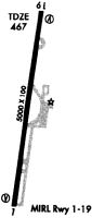
Runways
Runway Summary
| Runways: | 01/19 |
| Longest Runway: | 01/19 is 5002 ft (1525 m) long |
| Runways with an Instrument Approach: |
KSNH Airport Runway Details
| Runway 01/19 | 5002 ft x 100 ft (1525 m x 30 m) | |
| Runway Length Source: | 3RD PARTY SURVEY as of 06/29/2022 | |
| Surface: | Concrete - Good condition - No special surface treatment | |
| Runway Edge Lights: | Medium Intensity | |
Runway Weight Bearing Capacity (in thousands of pounds) |
||
| Single Wheel Landing Gear: | 45.0 | |
| Dual Wheel Landing Gear: | 60.0 | |
Runway 01 |
Runway 19 |
|
Elevation: |
472.7 | 454.2 |
Latitude: |
35-09-48.3630N | 35-10-37.4113N |
Longitude: |
088-13-04.1484W | 088-12-56.2795W |
|
Runway True Alignment: |
008 | 188 |
Glide Path Angle: |
3.0 degrees | 3.0 degrees |
Traffic Pattern: |
Left | Left |
Runway Markings Type: |
Nonprecision Instrument | Nonprecision Instrument |
Runway Markings Condition: |
Good | Good |
Object at End: |
TREES | |
Object Height: |
60 | 110 |
Distance from End: |
1324 | 2693 |
Object Centerline Offset: |
64 ft. right of centerline | 781 ft. left of centerline |
Visual Glide Slope Indicators: |
2-Light PAPI On Left Side Of Runway | 2-Light PAPI On Left Side Of Runway |
REIL: |
Yes | Yes |
Threshold Crossing Height: |
28 | 31 |
Services
Airframe Repair: |
Major |
Powerplant Repair: |
Major |
Fuel Available: |
100LL, Jet A+ |
Landing Fees: |
No |
Parking: |
Hangars and tiedowns available |
Maps & Diagrams
KSNH Sectional
Flight Planning
at skyvector.com
at skyvector.com