Location
Latitude: |
36-46-50.7533N (36.780765) |
Longitude: |
076-27-04.6093W (-76.45128) |
Elevation: |
28.0 feet MSL (9 m MSL) |
Magnetic Variation: |
10.7 W (as of April 2024 from WMM2020 model) |
Time Zone: |
UTC -5.0 (Standard Time) UTC -4.0 (Daylight Savings Time) |
From City: |
07 N.M. SW of Norfolk, Virginia |
Found On: |
Washington Chart |
FAA Region: |
AEA |
Contacts
Manager: |
Privately owned: |
| STEVE FOX 5172 W. MILITARY HWY CHESAPEAKE, VA 23321 757-465-0260 |
VIRGINIA AVIATION ASSOCIATES, L.L.C 5172 W. MILITARY HWY, SUITE A CHESAPEAKE, VA 23321 757-465-0260 |
Operations
Airport Status: |
Operational |
Facility Use: |
Public |
Type: |
Airport |
Control tower: |
No |
Attendance (Months/Days/Hours): |
Months/Days/Hours ALL/ALL/0630 - 2130 |
Boundary ARTCC: |
ZDC (Washington) |
Responsible ARTCC: |
ZDC (Washington) |
Lighting Schedule: |
SEE RMK |
Segmented Circle Indicator: |
No |
Traffic Pattern Altitude (MSL): |
1028 feet (313 m) |
NOTAMs Facility: |
DCA |
NOTAM-D Service: |
Yes |
International Airport of Entry: |
No |
Customs Landing Rights: |
No |
Military Landing Rights: |
No |
Civil/Military Joint Use: |
No |
Based Aircraft
| Single Engine: | 85 |
| Multi Engine: | 19 |
| Jet Engine: | 11 |
| GA Helicopters: | 13 |
Annual Operations (as of 10/31/2018)
| Total Operations: | 69792 | |
| Air Taxi: | 1611 | 2.3% |
| GA Local: | 17688 | 25.3% |
| GA Itinerant: | 50251 | 72.0% |
| Military Aircraft: | 242 | 0.3% |
Communications
| CTAF: | 122.725 |
| Unicom: | 122.725 |
| Approach: | NORFOLK |
| Departure: | NORFOLK |
| AWOS-3PT: | 118.375 (757-465-2175) |
Fixed Based Operators (FBOs) & Fuel
(Click on a business for detail)
Please help us keep this information up to date. This is a FREE SERVICE just like everything else on Airport Guide! If you see that a business needs to be added, modified, or deleted please fill out our Update Form.
To add, modify, or delete a business click here.
Please help us keep this information up to date. This is a FREE SERVICE just like everything else on Airport Guide! If you see that a business needs to be added, modified, or deleted please fill out our Update Form.
Area Code: 757 |
| Business Name | Frequency | Phone | Fuel Grade |
|---|---|---|---|
| Aerodyne Corporation
Website Update FBO info |
488-2898 | ||
| Bay Avionics
Update FBO info |
488-7700 | ||
| Curtis Eads Flight School
Update FBO info |
465-1692 | ||
| Mercury Air Center
Update FBO info |
Unicom 123.0 | 488-1687 | 100LL |
Flight Service Stations
| Primary | Alternate | |
| FSS on Field: | N | |
| FSS Name (ID): | Leesburg(DCA) | |
| Frequency: | ||
| Toll Free Phone: | 1-800-WX-BRIEF |
Instrument Procedures / Charts
FAA Terminal Procedures valid from 0901Z 03/21/24 to 0901Z 04/18/24.
There are various types of charts available for an airport. They are listed in the Page Type column. Here is a legend for those types:
APD - Airport Diagram
DP - Departure Procedure Charts
HOT - Hot Spots
IAP - Instrument Approach Procedure Charts
MIN - Minimums
STAR - Standard Terminal Arrival Charts
| Page Type | Page Name | Volume | Action Since Last Cycle |
|---|---|---|---|
| IAP | ILS OR LOC RWY 10 | NE-3 | |
| IAP | RNAV (GPS) RWY 10 | NE-3 | |
| IAP | RNAV (GPS) RWY 28 | NE-3 | |
| MIN | ALTERNATE MINIMUMS | NE-3 | |
| MIN | TAKEOFF MINIMUMS | NE-3 | |
| STAR | DRONE TWO | NE-3 | |
| STAR | DRONE TWO[DELIMITER] CONT.1 | NE-3 | |
| STAR | TERKS TWO | NE-3 |
Terminal Procedures are only available for airports in several countries with more being added all the time. If you are looking for a specific country's charts, please send an email to support(at)airportguide.com stating the country name. This will be used to prioritize the implementation.
Navigation Aids (Navaids) near KPVG
| Dist (NM) | ID | Morse Code | Name | Type | Freq | True Hdg | Mag Hdg |
|---|---|---|---|---|---|---|---|
| 10.3 | OR | _ _ _ . _ . | Ingle | NDB | 329 | 69 | 80 |
| 11.4 | EY | . _ . _ _ | Chesi | NDB | 233 | 162 | 173 |
| 12.7 | NGU | _ . _ _ . . . _ | Chambers | TACAN | 113.95 | 41 | 52 |
| 13.8 | ORF | _ _ _ . _ . . . _ . | Norfolk | VORTAC | 116.90 | 60 | 71 |
| 14.5 | RK | . _ . _ . _ | Waley | NDB | 249 | 221 | 232 |
| 18.8 | LFI | . _ . . . . _ . . . | Langley | TACAN | 112.30 | 13 | 24 |
| 20.1 | NTU | _ . _ . . _ | Oceana | TACAN | 116.60 | 82 | 93 |
| 21.2 | PJS | . _ _ . . _ _ _ . . . | Henry | NDB | 375 | 354 | 365 |
| 22.9 | FAF | . . _ . . _ . . _ . | Felker | NDB | 226 | 339 | 350 |
| 27.3 | FKN | . . _ . _ . _ _ . | Franklin | VORTAC | 110.60 | 261 | 272 |
| 29.0 | AKQ | . _ _ . _ _ _ . _ | Wakefield | NDB | 274 | 294 | 305 |
| 31.8 | CVI | _ . _ . . . . _ . . | Cofield | VORTAC | 114.60 | 219 | 230 |
| 31.9 | LLW | . _ . . . _ . . . _ _ | Woodville | NDB | 254 | 166 | 177 |
| 34.1 | ECG | . _ . _ . _ _ . | Elizabeth City | VOR-DME | 112.50 | 156 | 167 |
| 40.3 | CCV | _ . _ . _ . _ . . . . _ | Cape Charles | VORTAC | 112.20 | 32 | 43 |
| 42.0 | HCM | . . . . _ . _ . _ _ | Harcum | VORTAC | 108.80 | 342 | 353 |
| 45.7 | EDE | . _ . . . | Edenton | NDB | 265 | 187 | 198 |
| 45.8 | HPW | . . . . . _ _ . . _ _ | Hopewell | VORTAC | 112.00 | 316 | 327 |
| 47.9 | ELQ | . . _ . . _ _ . _ | Emporia | NDB | 261 | 258 | 268 |
| 56.7 | BDB | _ . . . _ . . _ . . . | Accom | NDB | 336 | 33 | 44 |
Nearby Airports with Fuel
Notices to Airmen (NOTAMS)
Remarks
| A110-2 | DEER ON & INVOF ARPT. |
| A110-3 | EXTENSIVE HELICOPTER TRAINING. |
| A110-4 | RWY 10/28 PREFERRED USE RWY. BE ALERT FOR MULTIPLE 1000 FT AGL TWRS 1.5 NM NW OF FLD. |
| A110-5 | FOR CD CTC NORFOLK APCH AT 757-464-0757. |
| A14 | STEVEN I. FOX AUTH PSNAL TO MAKE CHGS 757-465-0260. |
| A23-10 | FIXED WING ACFT. |
| A23-20 | FIXED WING ACFT. |
| A33-02/20 | RWY HAS NMRS CRACKS. TWYS SUPPORTING RWY HAVE NMRS CRACKS AND FOD POTENTIAL. |
| A57-02 | APCH RATIO 94:1 TO DSPLCD THR (ROAD); APCH RATIO 22:1 TO DSPLCD THR FM 70 FT TREE 883 FT FM RWY END, 189 FT LEFT. |
| A57-20 | APCH RATIO 22:1 TO DSPLCD THR CTLG OBST; APCH RATIO 21:1 TO DSPLCD THR FM 104 FT TREE 1505 FT FM RWY END, 108 FT RIGHT. |
| A58-28 | BRUSH LCTD APRXLY 240 FT FM CNTRLN. |
| A81-APT | ACTVT REIL RWY 10 & 28; PAPI RWY 10 & 28; MIRL RWY 02/20; HIRL RWY 10/28 - CTAF. |
| E111 | IN OPERN PRIOR TO 1959. |
| E147 | TPA 677 FT AGL FOR HELICOPTERS. |
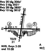
Runways
Runway Summary
| Runways: | 02/20 10/28 |
| Longest Runway: | 10/28 is 5350 ft (1631 m) long |
| Runways with an Instrument Approach: | 10 |
KPVG Airport Runway Details
| Runway 02/20 | 3525 ft x 70 ft (1074 m x 21 m) | |
| Runway Length Source: | 3RD PARTY SURVEY as of 11/17/2010 | |
| Surface: | Asphalt - Poor condition - No special surface treatment | |
| Runway Edge Lights: | Medium Intensity | |
Runway Weight Bearing Capacity (in thousands of pounds) |
||
| Single Wheel Landing Gear: | 12.5 | |
Runway 02 |
Runway 20 |
|
Elevation: |
21.2 | 19.6 |
Latitude: |
36-46-34.8032N | 36-47-09.2558N |
Longitude: |
076-26-58.3565W | 076-26-51.8076W |
|
Runway True Alignment: |
009 | 189 |
Glide Path Angle: |
0.0 degrees | 0.0 degrees |
Traffic Pattern: |
Left | Right |
Runway Markings Type: |
Nonprecision Instrument | Nonprecision Instrument |
Runway Markings Condition: |
Fair | Fair |
Object at End: |
ROAD | TREES |
Object Height: |
10 | 63 |
Distance from End: |
244 | 1541 |
Object Centerline Offset: |
125 ft. right of centerline | 201 ft. right of centerline |
Threshold Elevation: |
21.5 | 21.1 |
Displaced Threshold: |
898 | 928 |
Threshold Latitude: |
36-46-43.5778N | 36-47-00.1834N |
Threshold Longitude: |
076-26-56.6892W | 076-26-53.5341W |
| Runway 10/28 | 5350 ft x 100 ft (1631 m x 30 m) | |
| Runway Length Source: | 3RD PARTY SURVEY as of 08/08/2014 | |
| Surface: | Asphalt - Poor condition - Saw-cut or plastic grooved | |
| Runway Edge Lights: | High Intensity | |
Runway Weight Bearing Capacity (in thousands of pounds) |
||
| Dual Wheel Landing Gear: | 75.0 | |
Runway 10 |
Runway 28 |
|
Elevation: |
27.9 | 23.1 |
Latitude: |
36-46-51.0258N | 36-46-48.7984N |
Longitude: |
076-27-43.7397W | 076-26-38.0323W |
|
Runway True Alignment: |
092 | 272 |
ILS Type: |
ILS/DME | |
Glide Path Angle: |
3.0 degrees | 3.0 degrees |
Traffic Pattern: |
Right | Left |
Runway Markings Type: |
Precision Instrument | Nonprecision Instrument |
Runway Markings Condition: |
Good | Good |
Object at End: |
TREE | TREE |
Object Height: |
31 | 100 |
Distance from End: |
1424 | 2430 |
Object Centerline Offset: |
125 ft. right of centerline | 201 ft. right of centerline |
Visual Glide Slope Indicators: |
4-Light PAPI On Left Side Of Runway | 4-Light PAPI On Left Side Of Runway |
REIL: |
Yes | Yes |
Threshold Crossing Height: |
45 | 45 |
Services
Bottled Oxygen: |
None |
Bulk Oxygen: |
None |
Fuel Available: |
100LL |
Landing Fees: |
No |
Parking: |
Tiedowns available |
Maps & Diagrams
KPVG Sectional
Flight Planning
at skyvector.com
at skyvector.com