Location
Latitude: |
39-38-20.0043N (39.63889) |
Longitude: |
090-46-42.8123W (-90.778559) |
Elevation: |
709.8 feet MSL (216 m MSL) |
Magnetic Variation: |
1.6 W (as of April 2024 from WMM2020 model) |
Time Zone: |
UTC -6.0 (Standard Time) UTC -5.0 (Daylight Savings Time) |
From City: |
03 N.M. NE of Pittsfield, Illinois |
Found On: |
St Louis Chart |
FAA Region: |
AGL |
Contacts
Manager: |
Publicly owned: |
| MARK GERARD 29296 US HWY 54 PITTSFIELD, IL 62363 217-285-6027 |
CITY OF PITTSFIELD 215 N. MONROE ST PITTSFIELD, IL 62363 217-285-4484 |
Operations
Airport Status: |
Operational |
Facility Use: |
Public |
Type: |
Airport |
Activation Date: |
09/1974 |
Control tower: |
No |
Attendance (Months/Days/Hours): |
Months/Days/Hours ALL/MON-FRI/0800-1700 |
Boundary ARTCC: |
ZKC (Kansas City) |
Responsible ARTCC: |
ZKC (Kansas City) |
Lighting Schedule: |
SEE RMK |
Segmented Circle Indicator: |
Yes |
Traffic Pattern Altitude (MSL): |
1710 feet (521 m) |
NOTAMs Facility: |
PPQ |
NOTAM-D Service: |
Yes |
International Airport of Entry: |
No |
Customs Landing Rights: |
No |
Military Landing Rights: |
Yes |
Civil/Military Joint Use: |
No |
Based Aircraft
| Single Engine: | 7 |
| Multi Engine: | 2 |
| Jet Engine: | 1 |
Annual Operations (as of 04/30/2021)
| Total Operations: | 7000 | |
| Air Taxi: | 200 | 2.9% |
| GA Local: | 4700 | 67.1% |
| GA Itinerant: | 2000 | 28.6% |
| Military Aircraft: | 100 | 1.4% |
Communications
| CTAF: | 122.800 |
| Unicom: | 122.800 |
| AWOS-3PT: | 118.525 (217-285-1428) |
- APCH/DEP SVC PRVDD BY KANSAS CITY ARTCC ON FREQS 126.225/317.775 (QUINCY RCAG).
Fixed Based Operators (FBOs) & Fuel
(Click on a business for detail)
Please help us keep this information up to date. This is a FREE SERVICE just like everything else on Airport Guide! If you see that a business needs to be added, modified, or deleted please fill out our Update Form.
To add, modify, or delete a business click here.
Please help us keep this information up to date. This is a FREE SERVICE just like everything else on Airport Guide! If you see that a business needs to be added, modified, or deleted please fill out our Update Form.
Area Code: 217 |
| Business Name | Frequency | Phone | Fuel Grade |
|---|---|---|---|
| Pittsfield Penstone Municipal
Update FBO info |
285-6027 | 100LL, Jet A |
Flight Service Stations
| Primary | Alternate | |
| FSS on Field: | N | |
| FSS Name (ID): | Saint Louis(STL) | |
| Frequency: | ||
| Toll Free Phone: | 1-800-WX-BRIEF |
Instrument Procedures / Charts
FAA Terminal Procedures valid from 0901Z 03/21/24 to 0901Z 04/18/24.
There are various types of charts available for an airport. They are listed in the Page Type column. Here is a legend for those types:
APD - Airport Diagram
DP - Departure Procedure Charts
HOT - Hot Spots
IAP - Instrument Approach Procedure Charts
MIN - Minimums
STAR - Standard Terminal Arrival Charts
| Page Type | Page Name | Volume | Action Since Last Cycle |
|---|---|---|---|
| IAP | RNAV (GPS) RWY 13 | EC-3 | |
| IAP | RNAV (GPS) RWY 31 | EC-3 | |
| MIN | TAKEOFF MINIMUMS | EC-3 |
Terminal Procedures are only available for airports in several countries with more being added all the time. If you are looking for a specific country's charts, please send an email to support(at)airportguide.com stating the country name. This will be used to prioritize the implementation.
Navigation Aids (Navaids) near KPPQ
| Dist (NM) | ID | Morse Code | Name | Type | Freq | True Hdg | Mag Hdg |
|---|---|---|---|---|---|---|---|
| 26.3 | IJX | . . . _ _ _ _ . . _ | Jacksonville | DME | 108.6 | 71 | 73 |
| 26.3 | UIN | . . _ . . _ . | Quincy | TACAN | 113.60 | 298 | 299 |
| 26.5 | UI | . . _ . . | Quincy | NDB | 293 | 304 | 305 |
| 47.7 | SP | . . . . _ _ . | Huskk | NDB | 382 | 79 | 81 |
| 48.7 | STL | . . . _ . _ . . | St Louis | VORTAC | 117.40 | 163 | 165 |
| 52.2 | SPI | . . . . _ _ . . . | Spinner | VORTAC | 112.70 | 76 | 78 |
| 52.3 | LM | . _ . . _ _ | Oblio | NDB | 338 | 164 | 166 |
| 53.7 | JZY | . _ _ _ _ _ . . _ . _ _ | Macomb | NDB | 251 | 10 | 12 |
| 55.5 | CJ | _ . _ . . _ _ _ | Calde | NDB | 240 | 79 | 81 |
| 56.0 | CVM | _ . _ . . . . _ _ _ | Civic Memorial | NDB | 263 | 142 | 144 |
| 56.1 | ST | . . . _ | Zumay | NDB | 404 | 155 | 157 |
| 56.6 | CSX | _ . _ . . . . _ . . _ | Cardinal | DME | 116.45 | 159 | 161 |
| 56.6 | LQ | . _ . . _ _ . _ | Licol | NDB | 375 | 72 | 74 |
| 57.1 | STL | . . . _ . _ . . | St Louis Lambert | VOT | 111.00 | 160 | 162 |
| 57.4 | FTZ | . . _ . _ _ _ . . | Foristell | VORTAC | 110.80 | 189 | 191 |
| 58.0 | EOK | . _ _ _ _ . _ | Keokuk | NDB | 366 | 328 | 329 |
| 58.7 | FZ | . . _ . _ _ . . | Eaves | NDB | 227 | 169 | 171 |
| 58.9 | SUS | . . . . . _ . . . | Spirit Of St Louis | VOT | 112.20 | 174 | 176 |
| 60.0 | SU | . . . . . _ | Snoop | NDB | 326 | 179 | 181 |
| 61.1 | AL | . _ . _ . . | Alpos | NDB | 218 | 140 | 142 |
Nearby Airports with Fuel
Notices to Airmen (NOTAMS)
Remarks
| A110-2 | DEER & MIGRATORY WATERFOWL ON & INVOF ARPT. |
| A110-3 | (E81) TWY LGTS ARE LGTD EXIT ARROWS. |
| A110-4 | FOR CD CTC KANSAS CITY ARTCC AT 913-254-8508. |
| A42-13 | RWY 13 MARKINGS POOR DUE TO FADING. |
| A42-31 | RWY 31 MARKINGS POOR DUE TO FADING. |
| A43-13 | RY 13 PAPI, OPERATE CONTINUOUSLY. |
| A43-31 | RY 31 PAPI, OPERATE CONTINUOUSLY. |
| A70-FUEL-10 | 0LL 24 HR SELF SVC CREDIT CARD (MAJOR) FUEL FAC. |
| A81-APT | MIRL RY 13/31 PRESET ON LOW INTST; TO INCREASE INTST & ACTVT MIRL RY 13/31 - CTAF. |
Runways
Runway Summary
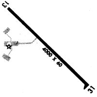
| Runways: | 13/31 |
| Longest Runway: | 13/31 is 4000 ft (1219 m) long |
| Runways with an Instrument Approach: |
KPPQ Airport Runway Details
| Runway 13/31 | 4000 ft x 60 ft (1219 m x 18 m) | |
| Runway Length Source: | 3RD PARTY SURVEY as of 03/25/2011 | |
| Surface: | Asphalt - Fair condition - No special surface treatment | |
| Runway Edge Lights: | Medium Intensity | |
Runway Weight Bearing Capacity (in thousands of pounds) |
||
| Single Wheel Landing Gear: | 12.0 | |
Runway 13 |
Runway 31 |
|
Elevation: |
709.8 | 694.6 |
Latitude: |
39-38-34.0079N | 39-38-06.0786N |
Longitude: |
090-47-00.9088W | 090-46-24.7176W |
|
Runway True Alignment: |
135 | 315 |
Glide Path Angle: |
3.0 degrees | 3.0 degrees |
Traffic Pattern: |
Left | Left |
Runway Markings Type: |
Nonprecision Instrument | Nonprecision Instrument |
Runway Markings Condition: |
Poor | Poor |
Visual Glide Slope Indicators: |
2-Light PAPI On Left Side Of Runway | 2-Light PAPI On Left Side Of Runway |
REIL: |
No | No |
Touchdown Lights: |
No | No |
Centerline Lights: |
No | No |
Threshold Crossing Height: |
32 | 29 |
Services
Airframe Repair: |
Major |
Powerplant Repair: |
Major |
Bottled Oxygen: |
None |
Bulk Oxygen: |
None |
Fuel Available: |
100LL |
Landing Fees: |
No |
Parking: |
Tiedowns available |
Maps & Diagrams
KPPQ Sectional
Flight Planning
at skyvector.com
at skyvector.com