Location
Latitude: |
35-48-38.8090N (35.81078) |
Longitude: |
076-45-30.1320W (-76.75837) |
Elevation: |
36.3 feet MSL (11 m MSL) |
Magnetic Variation: |
10.4 W (as of April 2024 from WMM2020 model) |
Time Zone: |
UTC -5.0 (Standard Time) UTC -4.0 (Daylight Savings Time) |
From City: |
02 N.M. S of Plymouth, North Carolina |
Found On: |
Charlotte Chart |
FAA Region: |
ASO |
Contacts
Manager: |
Publicly owned: |
| KNAPP BRABBLE 1069 AIRPORT RD. PLYMOUTH, NC 27962 252-793-9801 |
WASHINGTON COUNTY PO BOX 1007, 116 ADAMS STREET PLYMOUTH, NC 27962 252-793-5823 |
Operations
Airport Status: |
Operational |
Facility Use: |
Public |
Type: |
Airport |
Activation Date: |
03/1978 |
Control tower: |
No |
Attendance (Months/Days/Hours): |
Months/Days/Hours ALL/ALL/0800-1700 |
Boundary ARTCC: |
ZDC (Washington) |
Responsible ARTCC: |
ZDC (Washington) |
Lighting Schedule: |
SEE RMK |
Segmented Circle Indicator: |
Yes |
Traffic Pattern Altitude (MSL): |
1036 feet (316 m) |
NOTAMs Facility: |
RDU |
NOTAM-D Service: |
Yes |
Military Landing Rights: |
Yes |
Civil/Military Joint Use: |
No |
Based Aircraft
| Single Engine: | 7 |
| Multi Engine: | 1 |
Annual Operations (as of 06/24/2021)
| Total Operations: | 13000 | |
| GA Local: | 8000 | 61.5% |
| GA Itinerant: | 3000 | 23.1% |
| Military Aircraft: | 2000 | 15.4% |
Communications
| CTAF: | 122.800 |
| Unicom: | 122.800 |
| Approach: | CHERRY POINT 119.35 119.35 |
| Departure: | CHERRY POINT 119.35 119.35 |
Fixed Based Operators (FBOs) & Fuel
(Click on a business for detail)
Please help us keep this information up to date. This is a FREE SERVICE just like everything else on Airport Guide! If you see that a business needs to be added, modified, or deleted please fill out our Update Form.
To add, modify, or delete a business click here.
Please help us keep this information up to date. This is a FREE SERVICE just like everything else on Airport Guide! If you see that a business needs to be added, modified, or deleted please fill out our Update Form.
Area Code: 252 |
| Business Name | Frequency | Phone | Fuel Grade |
|---|
Flight Service Stations
| Primary | Alternate | |
| FSS on Field: | N | |
| FSS Name (ID): | Raleigh(RDU) | |
| Frequency: | ||
| Toll Free Phone: | 1-800-WX-BRIEF |
Instrument Procedures / Charts
FAA Terminal Procedures valid from 0901Z 03/21/24 to 0901Z 04/18/24.
There are various types of charts available for an airport. They are listed in the Page Type column. Here is a legend for those types:
APD - Airport Diagram
DP - Departure Procedure Charts
HOT - Hot Spots
IAP - Instrument Approach Procedure Charts
MIN - Minimums
STAR - Standard Terminal Arrival Charts
| Page Type | Page Name | Volume | Action Since Last Cycle |
|---|---|---|---|
| IAP | RNAV (GPS) RWY 03 | SE-2 | |
| IAP | RNAV (GPS) RWY 21 | SE-2 | |
| MIN | TAKEOFF MINIMUMS | SE-2 |
Terminal Procedures are only available for airports in several countries with more being added all the time. If you are looking for a specific country's charts, please send an email to support(at)airportguide.com stating the country name. This will be used to prioritize the implementation.
Navigation Aids (Navaids) near KPMZ
| Dist (NM) | ID | Morse Code | Name | Type | Freq | True Hdg | Mag Hdg |
|---|---|---|---|---|---|---|---|
| 15.9 | EDE | . _ . . . | Edenton | NDB | 265 | 35 | 46 |
| 20.6 | MCZ | _ _ _ . _ . _ _ . . | Williamston | NDB | 336 | 278 | 288 |
| 24.8 | RNW | . _ . _ . . _ _ | Chocowinity | NDB | 388 | 223 | 233 |
| 30.5 | AQE | . _ _ _ . _ . | Alwood | NDB | 230 | 258 | 268 |
| 32.1 | PGV | . _ _ . _ _ . . . . _ | Belvoir | FAN MARKER | 251 | 261 | |
| 34.2 | CVI | _ . _ . . . . _ . . | Cofield | VORTAC | 114.60 | 350 | 360 |
| 35.1 | LLW | . _ . . . _ . . . _ _ | Woodville | NDB | 254 | 39 | 50 |
| 39.0 | ECG | . _ . _ . _ _ . | Elizabeth City | VOR-DME | 112.50 | 46 | 57 |
| 39.0 | ETC | . _ _ . _ . | Tarboro | NDB | 257 | 281 | 291 |
| 46.4 | EWN | . . _ _ _ . | New Bern | VOR-DME | 113.60 | 197 | 207 |
| 47.0 | TYI | _ _ . _ _ . . | Tar River | VORTAC | 117.80 | 282 | 292 |
| 47.1 | ISO | . . . . . _ _ _ | Kinston | VORTAC | 117.50 | 236 | 246 |
| 47.6 | RK | . _ . _ . _ | Waley | NDB | 249 | 6 | 17 |
| 49.9 | EW | . . _ _ | Katfi | NDB | 362 | 198 | 208 |
| 50.7 | EY | . _ . _ _ | Chesi | NDB | 233 | 20 | 31 |
| 52.0 | RBX | . _ . _ . . . _ . . _ | Wright Brothers | VOR-DME | 111.60 | 82 | 93 |
| 52.1 | MQI | _ _ _ _ . _ . . | Manteo | NDB | 370 | 82 | 93 |
| 54.8 | NKT | _ . _ . _ _ | Cherry Point | TACAN | 112.80 | 186 | 196 |
| 55.6 | FKN | . . _ . _ . _ _ . | Franklin | VORTAC | 110.60 | 347 | 357 |
| 56.2 | OUC | _ _ _ . . _ _ . _ . | Pamlico/Dcmsnd | NDB-DME | 404 | 137 | 148 |
Nearby Airports with Fuel
Notices to Airmen (NOTAMS)
Remarks
| A110-1 | ARPT LCTD 5 MI W OF MIL RSTRD AREA; SAFETY PROBLEM DUE FAST MIL ACFT CROSSING ARPT BELOW 3000 FT MSL ENROUTE TO RSTRD AREA - CROSSINGS ARE UNANNOUNCED. |
| A110-3 | DEER ACTVTY INVOF ARPT. |
| A110-4 | FOR CD CTC WASHINGTON ARTCC AT 703-771-3587. |
| A17 | FOR SVC AFTER HRS CALL 252-793-9801. |
| A43-21 | UNUSBL BYD 8 DEG R OF CNTRLN. |
| A70-FUEL-10 | 0LL 24 HR SS FUELING WITH CC. |
| A81-APT | ACTVT REIL RWY 03 & 21; PAPI RWY 03 & 21; MIRL RWY 03/21 - CTAF. |
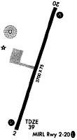
Runways
Runway Summary
| Runways: | 03/21 |
| Longest Runway: | 03/21 is 5500 ft (1676 m) long |
| Runways with an Instrument Approach: |
KPMZ Airport Runway Details
| Runway 03/21 | 5500 ft x 75 ft (1676 m x 23 m) | |
| Runway Length Source: | 3RD PARTY SURVEY as of 10/06/2019 | |
| Surface: | Asphalt - Good condition - No special surface treatment | |
| Runway Edge Lights: | Medium Intensity | |
Runway Weight Bearing Capacity (in thousands of pounds) |
||
| Single Wheel Landing Gear: | 25.0 | |
Runway 03 |
Runway 21 |
|
Elevation: |
36.3 | 34.9 |
Latitude: |
35-48-12.8584N | 35-49-04.7592N |
Longitude: |
076-45-40.1100W | 076-45-20.1516W |
|
Runway True Alignment: |
017 | 197 |
Glide Path Angle: |
4.0 degrees | 4.0 degrees |
Traffic Pattern: |
Left | Left |
Runway Markings Type: |
Nonprecision Instrument | Nonprecision Instrument |
Runway Markings Condition: |
Good | Good |
Object at End: |
TREES | TREES |
Object Height: |
43 | 97 |
Distance from End: |
243 | 2190 |
Object Centerline Offset: |
254 ft. left of centerline | 192 ft. left of centerline |
Visual Glide Slope Indicators: |
2-Light PAPI On Left Side Of Runway | 2-Light PAPI On Left Side Of Runway |
REIL: |
Yes | Yes |
Threshold Crossing Height: |
30 | 28 |
Services
Airframe Repair: |
Major |
Powerplant Repair: |
Major |
Bottled Oxygen: |
High Pressure / Low Pressure |
Fuel Available: |
100LL, Jet A-1+ |
Parking: |
Tiedowns available |
Maps & Diagrams
KPMZ Sectional
Flight Planning
at skyvector.com
at skyvector.com