Location
Latitude: |
59-27-05.5000N (59.451528) |
Longitude: |
157-22-23.4000W (-157.373167) |
Elevation: |
370.7 feet MSL (113 m MSL) |
Magnetic Variation: |
11.8 E (as of April 2024 from WMM2020 model) |
Time Zone: |
UTC -9.0 (Standard Time) UTC -8.0 (Daylight Savings Time) |
From City: |
01 N.M. W of New Stuyahok, Alaska |
Found On: |
Kodiak Chart |
FAA Region: |
AAL |
Contacts
Manager: |
Publicly owned: |
| JON TAYLOR BOX 250 DILLINGHAM, AK 99576 907-842-5511 |
ALASKA DOT&PF CENTRAL REGION PO BOX 196900 ANCHORAGE, AK 99519-6900 907-269-0749 |
Operations
Airport Status: |
Operational |
Facility Use: |
Public |
Type: |
Airport |
Control tower: |
No |
Attendance (Months/Days/Hours): |
Months/Days/Hours Unattended |
Boundary ARTCC: |
ZAN (Anchorage) |
Responsible ARTCC: |
ZAN (Anchorage) |
Lighting Schedule: |
SEE RMK |
Segmented Circle Indicator: |
Yes |
Traffic Pattern Altitude (MSL): |
1371 feet (418 m) |
NOTAMs Facility: |
KNW |
NOTAM-D Service: |
Yes |
International Airport of Entry: |
No |
Customs Landing Rights: |
No |
Military Landing Rights: |
Yes |
Civil/Military Joint Use: |
No |
Based Aircraft
Annual Operations (as of 12/31/2022)
| Total Operations: | 950 | |
| Air Taxi: | 250 | 26.3% |
| GA Itinerant: | 700 | 73.7% |
Communications
| CTAF: | 122.900 |
| AWOS-3P: | 120.275 (907-693-3086) |
- COMMUNICATIONS PRVDD BY DILLINGHAM FSS ON FREQ 122.55 0745-2345 (KEMUK MOUNTAIN RCO) OTHER TIMES CTC KENAI FSS.
- APCH/DEP SVC PRVDD BY ANCHORAGE ARTCC ON FREQS 132.75/282.35 (DILLINGHAM RCAG).
Fixed Based Operators (FBOs) & Fuel
(Click on a business for detail)
Please help us keep this information up to date. This is a FREE SERVICE just like everything else on Airport Guide! If you see that a business needs to be added, modified, or deleted please fill out our Update Form.
To add, modify, or delete a business click here.
Please help us keep this information up to date. This is a FREE SERVICE just like everything else on Airport Guide! If you see that a business needs to be added, modified, or deleted please fill out our Update Form.
Area Code: 907 |
| Business Name | Frequency | Phone | Fuel Grade |
|---|
Flight Service Stations
| Primary | Alternate | |
| FSS on Field: | N | |
| FSS Name (ID): | Dillingham(DLG) | Kenai (ENA) |
| Frequency: | ||
| Toll Free Phone: | LC842-5275 | 1-866-864-1737 |
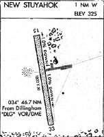
Instrument Procedures / Charts
FAA Terminal Procedures valid from 0901Z 03/21/24 to 0901Z 04/18/24.
There are various types of charts available for an airport. They are listed in the Page Type column. Here is a legend for those types:
APD - Airport Diagram
DP - Departure Procedure Charts
HOT - Hot Spots
IAP - Instrument Approach Procedure Charts
MIN - Minimums
STAR - Standard Terminal Arrival Charts
| Page Type | Page Name | Volume | Action Since Last Cycle |
|---|---|---|---|
| IAP | RNAV (GPS) RWY 14 | AK-1 | |
| IAP | RNAV (GPS) RWY 32 | AK-1 | |
| MIN | ALTERNATE MINIMUMS | AK-1 | |
| MIN | TAKEOFF MINIMUMS | AK-1 |
Terminal Procedures are only available for airports in several countries with more being added all the time. If you are looking for a specific country's charts, please send an email to support(at)airportguide.com stating the country name. This will be used to prioritize the implementation.
Navigation Aids (Navaids) near KNW
| Dist (NM) | ID | Morse Code | Name | Type | Freq | True Hdg | Mag Hdg |
|---|---|---|---|---|---|---|---|
| 45.1 | BTS | _ . . . _ . . . | Wood River | NDB | 429 | 233 | 221 |
| 45.4 | DLG | _ . . . _ . . _ _ . | Dillingham | VOR-DME | 116.40 | 233 | 221 |
| 46.6 | AUB | . _ . . _ _ . . . | Chinook | NDB | 355 | 156 | 144 |
| 47.6 | AKN | . _ _ . _ _ . | King Salmon | VORTAC | 112.80 | 156 | 144 |
| 60.3 | HCP | . . . . _ . _ . . _ _ . | Kulik Lake | NDB | 334 | 114 | 102 |
| 76.9 | ILI | . . . _ . . . . | Iliamna | NDB-DME | 411 | 75 | 63 |
| 95.0 | TOG | _ _ _ _ _ _ . | Togiak | NDB-DME | 393 | 257 | 246 |
Nearby Airports with Fuel
| Dist (NM) | Name (Airport IDs) | True Hdg | Mag Hdg | Fuel Grade |
|---|---|---|---|---|
| 39.4 | Aleknagik /New Airport (WKK 5A8) |
255 | 244 | 100LL, Jet A, Mogas |
| 39.7 | Aleknagik Seaplane Base (Z33) |
254 | 243 | 100LL, MOGAS |
| 42.5 | Dillingham Airport (DLG PADL DLG) |
235 | 224 | 100LL, Jet A |
| 51.6 | King Salmon Airport (AKN PAKN AKN) |
154 | 142 | 100LL, Jet A |
| 76.7 | Iliamna Airport (ILI PAIL ILI) |
75 | 62 | 100LL, Jet A |
Notices to Airmen (NOTAMS)
Remarks
| A110-10 | WX CAMERA AVBL ON INTERNET AT HTTPS://WEATHERCAMS.FAA.GOV |
| A110-11 | RY SLOPES DOWN TOWARD SOUTHEAST END OF RY. |
| A110-12 | BANKS ERODING AT RAMP, TAXIWAY AND RUNWAY OVERRUNS. |
| A110-13 | RWY SOFT WHEN WET. |
| A110-14 | NUMEROUS DIPS AT MIDFIELD |
| A75 | NO TIE DOWN ROPES. |
| A81-APT | ACTVT MIRL RY 14/32 AND PAPI & REIL RYS 14 & 32 - CTAF. |
| A81-BCN | ACTVT ROTG BCN - CTAF. |
Runways
Runway Summary
| Runways: | 14/32 |
| Longest Runway: | 14/32 is 3281 ft (1000 m) long |
| Runways with an Instrument Approach: |
KNW Airport Runway Details
| Runway 14/32 | 3281 ft x 75 ft (1000 m x 23 m) | |
| Runway Length Source: | 3RD PARTY SURVEY as of 07/02/2013 | |
| Surface: | Gravel - Good condition - No special surface treatment | |
| Runway Edge Lights: | Medium Intensity | |
Runway 14 |
Runway 32 |
|
Elevation: |
370.7 | 326.7 |
Latitude: |
59-27-19.9169N | 59-26-51.1628N |
Longitude: |
157-22-37.8835W | 157-22-08.9084W |
|
Runway True Alignment: |
153 | 333 |
Glide Path Angle: |
3.0 degrees | 3.0 degrees |
Traffic Pattern: |
Left | Left |
Visual Glide Slope Indicators: |
4-Light PAPI On Left Side Of Runway | 4-Light PAPI On Left Side Of Runway |
REIL: |
Yes | Yes |
Threshold Crossing Height: |
25 | 25 |
Services
Fuel Available: |
100LL, Jet A |
Parking: |
Tiedowns available |
Maps & Diagrams
KNW Sectional
Flight Planning
at skyvector.com
at skyvector.com