Location
Latitude: |
35-32-42.8350N (35.545232) |
Longitude: |
084-22-49.4410W (-84.3804) |
Elevation: |
1031.0 feet MSL (314 m MSL) |
Magnetic Variation: |
5.7 W (as of April 2024 from WMM2020 model) |
Time Zone: |
UTC -5.0 (Standard Time) UTC -4.0 (Daylight Savings Time) |
From City: |
02 N.M. NW of Madisonville, Tennessee |
Found On: |
Atlanta Chart |
FAA Region: |
ASO |
Contacts
Manager: |
Publicly owned: |
| TOM MCCOSH 105 COLLEGE STREET, SUITE 1 MADISONVILLE, TN 37354 423-420-0563 |
MONROE COUNTY MONROE CO COURTHOUSE, 105 COLLEGE STREET, SUITE 1 MADISONVILLE, TN 37354 423-442-3981 |
Operations
Airport Status: |
Operational |
Facility Use: |
Public |
Type: |
Airport |
Control tower: |
No |
Attendance (Months/Days/Hours): |
Months/Days/Hours ALL/ALL/0900-1700 |
Boundary ARTCC: |
ZTL (Atlanta) |
Responsible ARTCC: |
ZTL (Atlanta) |
Lighting Schedule: |
SEE RMK |
Segmented Circle Indicator: |
Yes |
Traffic Pattern Altitude (MSL): |
2031 feet (619 m) |
NOTAMs Facility: |
BNA |
NOTAM-D Service: |
Yes |
International Airport of Entry: |
No |
Customs Landing Rights: |
No |
Military Landing Rights: |
Yes |
Civil/Military Joint Use: |
No |
Based Aircraft
| Single Engine: | 34 |
| Multi Engine: | 2 |
Annual Operations (as of 04/30/2017)
| Total Operations: | 46150 | |
| Air Taxi: | 50 | 0.1% |
| GA Local: | 42000 | 91.0% |
| GA Itinerant: | 3600 | 7.8% |
| Military Aircraft: | 500 | 1.1% |
Communications
| CTAF: | 123.000 |
| Unicom: | 123.000 |
| Approach: | KNOXVILLE 123.9 123.9 |
| Departure: | KNOXVILLE 123.9 123.9 |
| AWOS-3: | 118.475 (423-442-6170) |
Fixed Based Operators (FBOs) & Fuel
(Click on a business for detail)
Please help us keep this information up to date. This is a FREE SERVICE just like everything else on Airport Guide! If you see that a business needs to be added, modified, or deleted please fill out our Update Form.
To add, modify, or delete a business click here.
Please help us keep this information up to date. This is a FREE SERVICE just like everything else on Airport Guide! If you see that a business needs to be added, modified, or deleted please fill out our Update Form.
Area Code: 423 |
| Business Name | Frequency | Phone | Fuel Grade |
|---|---|---|---|
| Tellico Air Service, Inc.
Update FBO info |
Unicom 123.0 | 442-4506, 253-2222 | 100LL, Mogas |
Flight Service Stations
| Primary | Alternate | |
| FSS on Field: | N | |
| FSS Name (ID): | Nashville(BNA) | |
| Frequency: | ||
| Toll Free Phone: | 1-800-WX-BRIEF |
Instrument Procedures / Charts
FAA Terminal Procedures valid from 0901Z 03/21/24 to 0901Z 04/18/24.
There are various types of charts available for an airport. They are listed in the Page Type column. Here is a legend for those types:
APD - Airport Diagram
DP - Departure Procedure Charts
HOT - Hot Spots
IAP - Instrument Approach Procedure Charts
MIN - Minimums
STAR - Standard Terminal Arrival Charts
| Page Type | Page Name | Volume | Action Since Last Cycle |
|---|---|---|---|
| IAP | RNAV (GPS) RWY 05 | SE-1 | |
| IAP | RNAV (GPS) RWY 23 | SE-1 | |
| MIN | ALTERNATE MINIMUMS | SE-1 | |
| MIN | TAKEOFF MINIMUMS | SE-1 |
Terminal Procedures are only available for airports in several countries with more being added all the time. If you are looking for a specific country's charts, please send an email to support(at)airportguide.com stating the country name. This will be used to prioritize the implementation.
Navigation Aids (Navaids) near KMNV
| Dist (NM) | ID | Morse Code | Name | Type | Freq | True Hdg | Mag Hdg |
|---|---|---|---|---|---|---|---|
| 0.1 | MNV | _ _ _ . . . . _ | Madisonville | NDB | 361 | 263 | 269 |
| 12.7 | MMI | _ _ _ _ . . | Mc Minn County | NDB | 242 | 224 | 230 |
| 24.8 | TYS | _ _ . _ _ . . . | Knoxville | VOT | 112.00 | 48 | 54 |
| 27.2 | DTE | _ . . _ . | Mark Anton | NDB | 394 | 262 | 268 |
| 32.0 | VXV | . . . _ _ . . _ . . . _ | Volunteer | VORTAC | 116.40 | 47 | 53 |
| 32.4 | HCH | . . . . _ . _ . . . . . | Hinch Mountain | VOR-DME | 117.60 | 296 | 302 |
| 34.8 | HDI | . . . . _ . . . . | Hardwick | NDB | 369 | 227 | 233 |
| 42.7 | HRS | . . . . . _ . . . . | Harris | VORTAC | 109.80 | 147 | 153 |
| 44.3 | CQN | _ . _ . _ _ . _ _ . | Daisy | NDB | 341 | 239 | 244 |
| 51.6 | GQO | _ _ . _ _ . _ _ _ _ | Choo Choo | DME | 115.8 | 227 | 232 |
| 53.0 | UWI | . . _ . _ _ . . | Whitfield | NDB | 400 | 211 | 217 |
| 55.6 | JXT | . _ _ _ _ . . _ _ | Jefferson | NDB | 346 | 52 | 58 |
| 59.8 | BPO | _ . . . . _ _ . _ _ _ | Piney Grove | NDB | 403 | 355 | 361 |
| 64.4 | HEM | . . . . . _ _ | Huchn | NDB | 233 | 294 | 299 |
| 65.7 | APT | . _ . _ _ . _ | Jasper | NDB | 382 | 244 | 249 |
| 66.4 | SOT | . . . _ _ _ _ | Snowbird | VORTAC | 108.80 | 76 | 82 |
| 68.6 | RN | . _ . _ . | Warri | NDB | 209 | 280 | 285 |
| 73.1 | LVT | . _ . . . . . _ _ | Livingston | VOR-DME | 114.35 | 328 | 334 |
| 73.6 | ODF | _ _ _ _ . . . . _ . | Foothills | VOR-DME | 113.40 | 133 | 139 |
| 73.7 | OUK | _ _ _ . . _ _ . _ | Calhoun | NDB | 323 | 201 | 206 |
Nearby Airports with Fuel
Notices to Airmen (NOTAMS)
Remarks
| A110-1 | FOR CD CTC KNOXVILLE APCH AT 865-980-3034; IF UNA FOR CD CTC KNOXVILLE APCH AT 865-980-3033. |
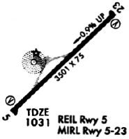
| A81-APT | REIL RWY 5 & 23 SS-SR. |
Runways
Runway Summary
| Runways: | 05/23 |
| Longest Runway: | 05/23 is 3643 ft (1110 m) long |
| Runways with an Instrument Approach: |
KMNV Airport Runway Details
| Runway 05/23 | 3643 ft x 75 ft (1110 m x 23 m) | |
| Runway Length Source: | 3RD PARTY SURVEY as of 08/18/2018 | |
| Surface: | Asphalt - Good condition - No special surface treatment | |
| Runway Edge Lights: | Medium Intensity | |
Runway Weight Bearing Capacity (in thousands of pounds) |
||
| Single Wheel Landing Gear: | 22.0 | |
| Dual Wheel Landing Gear: | 35.0 | |
Runway 05 |
Runway 23 |
|
Elevation: |
1030.2 | 1000.8 |
Latitude: |
35-32-29.8323N | 35-32-55.8377N |
Longitude: |
084-23-04.6904W | 084-22-34.1912W |
|
Runway True Alignment: |
044 | 224 |
Glide Path Angle: |
0.0 degrees | 0.0 degrees |
Traffic Pattern: |
Left | Left |
Runway Markings Type: |
Nonprecision Instrument | Nonprecision Instrument |
Runway Markings Condition: |
Good | Good |
REIL: |
Yes | Yes |
Threshold Elevation: |
1002.3 | |
Displaced Threshold: |
140 | |
Threshold Latitude: |
35-32-54.8384N | |
Threshold Longitude: |
084-22-35.3603W |
Services
Fuel Available: |
100LL, Jet A+, MOGAS |
Landing Fees: |
No |
Parking: |
Hangars and tiedowns available |
Maps & Diagrams
KMNV Sectional
Flight Planning
at skyvector.com
at skyvector.com