Location
Latitude: |
44-51-13.2000N (44.853667) |
Longitude: |
074-19-44.2000W (-74.328944) |
Elevation: |
789.9 feet MSL (241 m MSL) |
Magnetic Variation: |
13.3 W (as of April 2024 from WMM2020 model) |
Time Zone: |
UTC -5.0 (Standard Time) UTC -4.0 (Daylight Savings Time) |
From City: |
02 N.M. W of Malone, New York |
Found On: |
Montreal Chart |
FAA Region: |
AEA |
Contacts
Manager: |
Publicly owned: |
| BRUCE BURDITT 27 AIRPORT ROAD MALONE, NY 12953 (518) 483-4740 |
TOWN OF MALONE 27 AIRPORT ROAD MALONE, NY 12953 (518) 483-4740 |
Operations
Airport Status: |
Operational |
Facility Use: |
Public |
Type: |
Airport |
Activation Date: |
11/1942 |
Control tower: |
No |
Boundary ARTCC: |
ZBW (Boston) |
Responsible ARTCC: |
ZBW (Boston) |
Lighting Schedule: |
SEE RMK |
Segmented Circle Indicator: |
Yes |
Traffic Pattern Altitude (MSL): |
1790 feet (546 m) |
NOTAMs Facility: |
BTV |
NOTAM-D Service: |
Yes |
International Airport of Entry: |
No |
Customs Landing Rights: |
No |
Military Landing Rights: |
Yes |
Civil/Military Joint Use: |
No |
Based Aircraft
| Single Engine: | 14 |
Annual Operations (as of 07/15/2020)
| Total Operations: | 8700 | |
| Air Taxi: | 500 | 5.7% |
| GA Local: | 3800 | 43.7% |
| GA Itinerant: | 4200 | 48.3% |
| Military Aircraft: | 200 | 2.3% |
Communications
| CTAF: | 122.800 |
| Unicom: | 122.800 |
| AWOS-AV: | 122.8 ((518) 651-2601) |
- APCH/DEP SVC PRVDD BY BOSTON ARTCC ON FREQS 135.25/377.1 (TURIN RCAG).
Fixed Based Operators (FBOs) & Fuel
(Click on a business for detail)
Please help us keep this information up to date. This is a FREE SERVICE just like everything else on Airport Guide! If you see that a business needs to be added, modified, or deleted please fill out our Update Form.
To add, modify, or delete a business click here.
Please help us keep this information up to date. This is a FREE SERVICE just like everything else on Airport Guide! If you see that a business needs to be added, modified, or deleted please fill out our Update Form.
Area Code: 518 |
| Business Name | Frequency | Phone | Fuel Grade |
|---|---|---|---|
| Malone Aviation Services, Inc.
Update FBO info |
Unicom 122.8 | 481-5521 |
Flight Service Stations
| Primary | Alternate | |
| FSS on Field: | N | |
| FSS Name (ID): | Burlington(BTV) | |
| Frequency: | ||
| Toll Free Phone: | 1-800-WX-BRIEF |
Instrument Procedures / Charts
FAA Terminal Procedures valid from 0901Z 03/21/24 to 0901Z 04/18/24.
There are various types of charts available for an airport. They are listed in the Page Type column. Here is a legend for those types:
APD - Airport Diagram
DP - Departure Procedure Charts
HOT - Hot Spots
IAP - Instrument Approach Procedure Charts
MIN - Minimums
STAR - Standard Terminal Arrival Charts
| Page Type | Page Name | Volume | Action Since Last Cycle |
|---|---|---|---|
| IAP | RNAV (GPS) RWY 05 | NE-2 | |
| IAP | RNAV (GPS) RWY 23 | NE-2 | |
| MIN | TAKEOFF MINIMUMS | NE-2 |
Terminal Procedures are only available for airports in several countries with more being added all the time. If you are looking for a specific country's charts, please send an email to support(at)airportguide.com stating the country name. This will be used to prioritize the implementation.
Navigation Aids (Navaids) near KMAL
| Dist (NM) | ID | Morse Code | Name | Type | Freq | True Hdg | Mag Hdg |
|---|---|---|---|---|---|---|---|
| 17.1 | MSS | _ _ . . . . . . | Massena | TACAN | 114.10 | 282 | 295 |
| 24.2 | SLK | . . . . _ . . _ . _ | Briel | NDB | 395 | 158 | 171 |
| 24.2 | SL | . . . . _ . . | Briel | NDB | 395 | 158 | 171 |
| 24.8 | PTD | . _ _ . _ _ . . | Potsdam | NDB | 400 | 251 | 264 |
| 25.0 | MS | _ _ . . . | Misse | NDB | 278 | 270 | 283 |
| 28.6 | SLK | . . . . _ . . _ . _ | Saranac Lake | DME | 109.2 | 169 | 182 |
| 35.8 | PLB | . _ _ . . _ . . _ . . . | Plattsburgh | VORTAC | 116.90 | 106 | 119 |
| 41.7 | UL | Montreal | NDB | 248 | 29 | 43 | |
| 43.0 | ZDV | Valois | NDB | 201 | 32 | 46 | |
| 43.8 | IUL | Montreal | DME | 109.30 | 32 | 46 | |
| 44.1 | IOA | Montreal Dorval Intl | DME | 110.50 | 34 | 48 | |
| 44.6 | OG | _ _ _ _ _ . | Ogive | NDB | 358 | 258 | 271 |
| 47.4 | ZMR | Hermas | NDB | 272 | 12 | 25 | |
| 48.2 | YUL | _ . _ _ . . _ . _ . . | Montreal | VOR-DME | 116.30 | 18 | 32 |
| 49.1 | YJN | St-Jean | VORTAC | 115.80 | 60 | 74 | |
| 49.1 | YJN | _ . _ _ . _ _ _ _ . | St Jean | VOR-DME | 115.80 | 60 | 74 |
| 49.3 | ZUL | Rockland | NDB | 348 | 35 | 49 | |
| 49.9 | BT | _ . . . _ | Herro | NDB | 382 | 112 | 126 |
| 50.0 | ZMM | Joly | NDB | 266 | 6 | 19 | |
| 50.2 | ZMT | Jarry | NDB | 284 | 34 | 48 |
Nearby Airports with Fuel
Notices to Airmen (NOTAMS)
Remarks
| A110-3 | HAYING ACTIVITY & EQUIPMENT PRESENT JUN - SEP. |
| A110-4 | RY 14/32 HAS SNOW REMOVAL BUT VISUAL INSPECTION & NOTAM CHECK MUST BE DONE AS TOWN ROADS ARE PLOWED BEFORE ARPT. |
| A110-5 | FOR CD CTC BOSTON ARTCC AT 603-879-6859. |
| A110-6 | AIRPORT NOT ATTENDED |
| A57-32 | APCH SLOPE 21:1, DUE TO +72 FT BLDG, 1572 FT FM DSPLCD THLD; +38 FT TREES, 805 FT FM DSPLCD THLD. |
| A58-14 | +5 FT CROPS 67 FT FROM THLD, 107 FT RIGHT. |
| A58-32 | +18 FT ROAD WITH TALL FARM EQUIPMENT, 27 FT FM RWY, ACROSS CNTRLN. |
| A81-APT | ACTVT PAPI RWY 05 & 23, MIRL RWY 05/23, 14/32 & TWY LGTS - CTAF. |
| E111 | FILED FOR RECORD PURPOSES ONLY. |
Runways
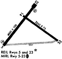
Runway Summary
| Runways: | 05/23 14/32 |
| Longest Runway: | 05/23 is 3994 ft (1217 m) long |
| Runways with an Instrument Approach: |
KMAL Airport Runway Details
| Runway 05/23 | 3994 ft x 100 ft (1217 m x 30 m) | |
| Runway Length Source: | 3RD PARTY SURVEY as of 10/25/2011 | |
| Surface: | Asphalt - Excellent condition - No special surface treatment | |
| Runway Edge Lights: | Medium Intensity | |
Runway Weight Bearing Capacity (in thousands of pounds) |
||
| Single Wheel Landing Gear: | 20.0 | |
Runway 05 |
Runway 23 |
|
Elevation: |
770.7 | 754.4 |
Latitude: |
44-50-58.1113N | 44-51-29.6551N |
Longitude: |
074-20-10.6677W | 074-19-37.3865W |
|
Runway True Alignment: |
037 | 217 |
Glide Path Angle: |
3.1 degrees | 3.0 degrees |
Traffic Pattern: |
Left | Left |
Runway Markings Type: |
Nonprecision Instrument | Nonprecision Instrument |
Runway Markings Condition: |
Good | Good |
Object at End: |
TREES | TREES |
Object Height: |
36 | 20 |
Distance from End: |
392 | 671 |
Object Centerline Offset: |
255 ft. left of centerline | 285 ft. right of centerline |
Visual Glide Slope Indicators: |
2-Light PAPI On Left Side Of Runway | 2-Light PAPI On Left Side Of Runway |
REIL: |
Yes | Yes |
Touchdown Lights: |
No | No |
Centerline Lights: |
No | No |
Threshold Crossing Height: |
42 | 43 |
Declared Distances |
||
Take Off Run Avbl. (TORA): |
3994 | 3994 |
Take Off Distance Avbl. (TODA): |
3994 | 3994 |
Actual Stop Dist. Avbl. (ASDA): |
3994 | 3994 |
Landing Dist. Avbl. (LDA): |
3994 | 3994 |
| Runway 14/32 | 3250 ft x 75 ft (991 m x 23 m) | |
| Runway Length Source: | 3RD PARTY SURVEY as of 10/25/2011 | |
| Surface: | Asphalt - Excellent condition - No special surface treatment | |
| Runway Edge Lights: | Medium Intensity | |
Runway Weight Bearing Capacity (in thousands of pounds) |
||
| Single Wheel Landing Gear: | 12.5 | |
Runway 14 |
Runway 32 |
|
Elevation: |
759.5 | 789.9 |
Latitude: |
44-51-21.9048N | 44-51-02.6424N |
Longitude: |
074-19-50.1990W | 074-19-14.1261W |
|
Runway True Alignment: |
127 | 307 |
Glide Path Angle: |
0.0 degrees | 0.0 degrees |
Runway Markings Type: |
Basic | Basic |
Runway Markings Condition: |
Good | Fair |
Object at End: |
TREES | TREE |
Object Height: |
30 | 18 |
Distance from End: |
815 | 200 |
Object Centerline Offset: |
255 ft. left of centerline | 285 ft. right of centerline |
Threshold Elevation: |
787.2 | |
Displaced Threshold: |
348 | |
Threshold Latitude: |
44-51-04.7048N | |
Threshold Longitude: |
074-19-17.9887W | |
Declared Distances |
||
Take Off Run Avbl. (TORA): |
3250 | 3250 |
Take Off Distance Avbl. (TODA): |
3250 | 3250 |
Actual Stop Dist. Avbl. (ASDA): |
3250 | 3250 |
Landing Dist. Avbl. (LDA): |
3250 | 2902 |
Services
Airframe Repair: |
Major |
Powerplant Repair: |
Major |
Bottled Oxygen: |
None |
Bulk Oxygen: |
None |
Fuel Available: |
100LL, Jet A |
Landing Fees: |
Yes |
Parking: |
Hangars and tiedowns available |
Maps & Diagrams
KMAL Sectional
Flight Planning
at skyvector.com
at skyvector.com