Location
Latitude: |
45-21-42.6600N (45.36185) |
Longitude: |
068-32-04.0480W (-68.534458) |
Elevation: |
207.9 feet MSL (63 m MSL) |
Magnetic Variation: |
15.6 W (as of April 2024 from WMM2020 model) |
Time Zone: |
UTC -5.0 (Standard Time) UTC -4.0 (Daylight Savings Time) |
From City: |
02 N.M. SW of Lincoln, Maine |
Found On: |
Halifax Chart |
FAA Region: |
ANE |
Contacts
Manager: |
Publicly owned: |
| DENNIS BULLEN 29 MAIN ST LINCOLN, ME 04457 207-794-3372 |
TOWN OF LINCOLN 29 MAIN ST LINCOLN, ME 04457 207-794-3372 |
Operations
Airport Status: |
Operational |
Facility Use: |
Public |
Type: |
Airport |
Activation Date: |
12/1972 |
Control tower: |
No |
Attendance (Months/Days/Hours): |
Months/Days/Hours Unattended |
Boundary ARTCC: |
ZBW (Boston) |
Responsible ARTCC: |
ZBW (Boston) |
Lighting Schedule: |
SEE RMK |
Segmented Circle Indicator: |
Yes |
Traffic Pattern Altitude (MSL): |
1208 feet (368 m) |
NOTAMs Facility: |
BGR |
NOTAM-D Service: |
Yes |
International Airport of Entry: |
No |
Customs Landing Rights: |
No |
Military Landing Rights: |
Yes |
Civil/Military Joint Use: |
No |
Based Aircraft
| Single Engine: | 28 |
Annual Operations (as of 08/09/2021)
| Total Operations: | 5500 | |
| GA Local: | 4250 | 77.3% |
| GA Itinerant: | 260 | 4.7% |
| Military Aircraft: | 990 | 18.0% |
Communications
| CTAF: | 122.800 |
| Unicom: | 122.800 |
- APCH/DEP SVC PRVDD BY BOSTON ARTCC ON FREQ 124.25/290.50 (BANGOR RCAG).
Fixed Based Operators (FBOs) & Fuel
(Click on a business for detail)
Please help us keep this information up to date. This is a FREE SERVICE just like everything else on Airport Guide! If you see that a business needs to be added, modified, or deleted please fill out our Update Form.
To add, modify, or delete a business click here.
Please help us keep this information up to date. This is a FREE SERVICE just like everything else on Airport Guide! If you see that a business needs to be added, modified, or deleted please fill out our Update Form.
Area Code: 207 |
| Business Name | Frequency | Phone | Fuel Grade |
|---|
Flight Service Stations
| Primary | Alternate | |
| FSS on Field: | N | |
| FSS Name (ID): | Bangor(BGR) | |
| Frequency: | ||
| Toll Free Phone: | 1-800-WX-BRIEF |
Instrument Procedures / Charts
FAA Terminal Procedures valid from 0901Z 03/21/24 to 0901Z 04/18/24.
There are various types of charts available for an airport. They are listed in the Page Type column. Here is a legend for those types:
APD - Airport Diagram
DP - Departure Procedure Charts
HOT - Hot Spots
IAP - Instrument Approach Procedure Charts
MIN - Minimums
STAR - Standard Terminal Arrival Charts
| Page Type | Page Name | Volume | Action Since Last Cycle |
|---|---|---|---|
| IAP | RNAV (GPS) RWY 16 | NE-1 | |
| IAP | RNAV (GPS) RWY 34 | NE-1 | |
| MIN | TAKEOFF MINIMUMS | NE-1 |
Terminal Procedures are only available for airports in several countries with more being added all the time. If you are looking for a specific country's charts, please send an email to support(at)airportguide.com stating the country name. This will be used to prioritize the implementation.
Navigation Aids (Navaids) near KLRG
| Dist (NM) | ID | Morse Code | Name | Type | Freq | True Hdg | Mag Hdg |
|---|---|---|---|---|---|---|---|
| 13.5 | MLT | _ _ . _ . . _ | Millinocket | VOR-DME | 117.90 | 3 | 19 |
| 17.2 | LNT | . _ . . _ . _ | Milnot | NDB | 344 | 357 | 373 |
| 21.8 | OLD | _ _ _ . _ . . _ . . | Old Town | NDB | 272 | 191 | 207 |
| 34.4 | BGR | _ . . . _ _ . . _ . | Bangor | VORTAC | 114.80 | 204 | 220 |
| 35.1 | PNN | . _ _ . _ . _ . | Princeton | DME | 114.3 | 92 | 108 |
| 35.9 | BGR | _ . . . _ _ . . _ . | Bangor | VOT | 111.00 | 199 | 215 |
| 50.1 | HUL | . . . . . . _ . _ . . | Houlton | DME | 116.1 | 35 | 51 |
| 50.3 | BH | _ . . . . . . . | Surry | NDB | 330 | 168 | 184 |
| 53.0 | BUP | _ . . . . . _ . _ _ . | Burnham | NDB | 348 | 221 | 236 |
| 60.5 | BST | _ . . . . . . _ | Belfast | NDB | 278 | 199 | 214 |
| 69.8 | EPM | . . _ _ . _ _ | Eastport | NDB | 260 | 112 | 128 |
| 74.4 | RL | . _ . . _ . . | Bracy | NDB | 399 | 223 | 238 |
| 77.9 | PQ | . _ _ . _ _ . _ | Excal | NDB | 278 | 15 | 31 |
| 80.2 | AU | . _ . . _ | Dunns | NDB | 366 | 225 | 240 |
| 81.5 | RM | . _ . _ _ | Noxks | NDB | 334 | 201 | 216 |
| 82.4 | SUH | . . . . . _ . . . . | Sprucehead | NDB | 356 | 197 | 212 |
| 82.4 | AUG | . _ . . _ _ _ . | Augusta | VOR-DME | 114.95 | 221 | 236 |
| 83.0 | 6E | Grand Manan | NDB | 387 | 117 | 133 | |
| 86.7 | PQI | . _ _ . _ _ . _ . . | Presque Isle | VOR-DME | 116.40 | 12 | 28 |
| 87.7 | FC | Fredericton | NDB | 326 | 66 | 82 |
Nearby Airports with Fuel
Notices to Airmen (NOTAMS)
Remarks
| A110-1 | 40 FT BRIDGE AT S END WATER LDG AREA. |
| A110-2 | WILDLIFE ON & INVOF ARPT. |
| A110-3 | RWY 6W-24W FOLLOW BUOYS UNDER BRIDGE DURING LOW WATER IN SUMMER. |
| A110-5 | FOR CD CTC BOSTON ARTCC AT 603-879-6859. |
| A16 | ALTN NR 207-290-7174. |
| A58-16 | +8 FT BRUSH 150 FT FM THR 85 FT R OF CNTRLN; 12 FT BRUSH 180-200 FT FM THR 80 FT L OF CNTRLN. |
| A58-34 | +8-12 FT BRUSH 100 FT FM THR 85 FT L OF CNTRLN. |
| A70-FUEL-10 | 0LL 24 HR FUEL WITH MAJOR CREDIT CARD. |
| A75 | AVBL O/R. |
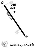
| A81-APT | ACTVT REIL RWY 17 & 35; MIRL RWY 17/35 - CTAF. |
| E111 | VFR ONLY. |
Runways
Runway Summary
| Runways: | 06W/24W 16/34 |
| Longest Runway: | 16/34 is 2805 ft (855 m) long |
| Runways with an Instrument Approach: |
KLRG Airport Runway Details
| Waterway 06W/24W | 2400 ft x 100 ft (732 m x 30 m) | |
| Runway Length Source: | STATE as of 01/05/2004 | |
| Surface: | Water - No special surface treatment | |
Waterway 06W |
Runway 24W |
|
Glide Path Angle: |
0.0 degrees | 0.0 degrees |
Traffic Pattern: |
Left | Left |
Object at End: |
PLINE | TREES |
Object Height: |
64 | 94 |
Object Marked/Lighted?: |
Marked | |
Distance from End: |
960 | 1410 |
Object Centerline Offset: |
0 ft. left and right of centerline | 0 ft. left and right of centerline |
| Waterway 16/34 | 2805 ft x 60 ft (855 m x 18 m) | |
| Runway Length Source: | 3RD PARTY SURVEY as of 03/21/2023 | |
| Surface: | Water - No special surface treatment | |
| Runway Edge Lights: | Medium Intensity | |
Runway Weight Bearing Capacity (in thousands of pounds) |
||
| Single Wheel Landing Gear: | 25.0 | |
Waterway 16 |
Runway 34 |
|
Elevation: |
196.5 | 206.4 |
Latitude: |
45-21-54.3077N | 45-21-31.0127N |
Longitude: |
068-32-14.6697W | 068-31-53.4268W |
|
Runway True Alignment: |
147 | 327 |
Glide Path Angle: |
0.0 degrees | 0.0 degrees |
Traffic Pattern: |
Left | Left |
Runway Markings Type: |
Nonprecision Instrument | Nonprecision Instrument |
Runway Markings Condition: |
Good | Good |
Object at End: |
TREES | TREES |
Object Height: |
12 | 61 |
Distance from End: |
201 | 460 |
Object Centerline Offset: |
0 ft. left and right of centerline | 0 ft. left and right of centerline |
REIL: |
Yes | Yes |
Services
Airframe Repair: |
None |
Powerplant Repair: |
None |
Bottled Oxygen: |
None |
Bulk Oxygen: |
None |
Fuel Available: |
100LL |
Landing Fees: |
No |
Parking: |
Hangars and tiedowns available |
Maps & Diagrams
KLRG Sectional
Flight Planning
at skyvector.com
at skyvector.com