Location
Latitude: |
40-45-31.4724N (40.758742) |
Longitude: |
087-25-44.8511W (-87.429125) |
Elevation: |
699.0 feet MSL (213 m MSL) |
Magnetic Variation: |
4.2 W (as of April 2024 from WMM2020 model) |
Time Zone: |
UTC -6.0 (Standard Time) UTC -5.0 (Daylight Savings Time) |
From City: |
01 N.M. SE of Kentland, Indiana |
Found On: |
Chicago Chart |
FAA Region: |
AGL |
Contacts
Manager: |
Publicly owned: |
| JIM BUTLER 2291E 1635S KENTLAND, IN 47951 219-863-7620 |
KENTLAND BOARD OF AVIATION COMM 2291 W. 1635 S. KENTLAND, IN 47951 219-863-7620 |
Operations
Airport Status: |
Operational |
Facility Use: |
Public |
Type: |
Airport |
Activation Date: |
11/1975 |
Control tower: |
No |
Attendance (Months/Days/Hours): |
Months/Days/Hours ALL/MON-FRI/0800-1600 |
Boundary ARTCC: |
ZAU (Chicago) |
Responsible ARTCC: |
ZAU (Chicago) |
Lighting Schedule: |
SEE RMK |
Segmented Circle Indicator: |
No |
Traffic Pattern Altitude (MSL): |
1699 feet (518 m) |
NOTAMs Facility: |
HUF |
NOTAM-D Service: |
Yes |
Based Aircraft
| Single Engine: | 14 |
Annual Operations (as of 12/31/2019)
| Total Operations: | 3778 | |
| Air Taxi: | 378 | 10.0% |
| GA Local: | 3211 | 85.0% |
| GA Itinerant: | 189 | 5.0% |
Communications
| CTAF: | 122.800 |
| Unicom: | 122.800 |
- APCH/DEP SVC PRVDD BY CHICAGO ARTCC (ZAU) ON FREQS 132.5/284.7 (KANKAKEE RCAG).
Fixed Based Operators (FBOs) & Fuel
(Click on a business for detail)
Please help us keep this information up to date. This is a FREE SERVICE just like everything else on Airport Guide! If you see that a business needs to be added, modified, or deleted please fill out our Update Form.
To add, modify, or delete a business click here.
Please help us keep this information up to date. This is a FREE SERVICE just like everything else on Airport Guide! If you see that a business needs to be added, modified, or deleted please fill out our Update Form.
Area Code: 219 |
| Business Name | Frequency | Phone | Fuel Grade |
|---|
Flight Service Stations
| Primary | Alternate | |
| FSS on Field: | N | |
| FSS Name (ID): | Terre Haute(HUF) | |
| Frequency: | ||
| Toll Free Phone: | 1-800-WX-BRIEF |
Instrument Procedures / Charts
FAA Terminal Procedures valid from 0901Z 03/21/24 to 0901Z 04/18/24.
There are various types of charts available for an airport. They are listed in the Page Type column. Here is a legend for those types:
APD - Airport Diagram
DP - Departure Procedure Charts
HOT - Hot Spots
IAP - Instrument Approach Procedure Charts
MIN - Minimums
STAR - Standard Terminal Arrival Charts
| Page Type | Page Name | Volume | Action Since Last Cycle |
|---|---|---|---|
| IAP | RNAV (GPS) RWY 27 | EC-2 | |
| MIN | TAKEOFF MINIMUMS | EC-2 |
Terminal Procedures are only available for airports in several countries with more being added all the time. If you are looking for a specific country's charts, please send an email to support(at)airportguide.com stating the country name. This will be used to prioritize the implementation.
Navigation Aids (Navaids) near KKT
| Dist (NM) | ID | Morse Code | Name | Type | Freq | True Hdg | Mag Hdg |
|---|---|---|---|---|---|---|---|
| 20.4 | BVT | _ . . . . . . _ _ | Boiler | VORTAC | 115.10 | 126 | 130 |
| 26.3 | LA | . _ . . . _ | Earle | NDB | 401 | 139 | 143 |
| 26.6 | IK | . . _ . _ | Lukow | NDB | 272 | 305 | 309 |
| 26.9 | IKK | . . _ . _ _ . _ | Kankakee | DME | 111.6 | 314 | 318 |
| 28.5 | DNV | _ . . _ . . . . _ | Danville | VORTAC | 111.00 | 191 | 195 |
| 28.5 | DN | _ . . _ . | Julip | NDB | 332 | 189 | 193 |
| 34.8 | EON | . _ _ _ _ . | Peotone | VORTAC | 113.20 | 331 | 335 |
| 35.1 | RBS | . _ . _ . . . . . . | Roberts | VOR-DME | 116.80 | 252 | 256 |
| 42.4 | RWN | . _ . . _ _ _ . | Winamac/Dcmsnd | NDB | 335 | 61 | 66 |
| 45.5 | CGT | _ . _ . _ _ . _ | Chicago Heights | VORTAC | 114.20 | 351 | 355 |
| 48.5 | VP | . . . _ . _ _ . | Sedly | NDB | 212 | 30 | 34 |
| 48.9 | OXI | _ _ _ _ . . _ . . | Knox | DME | 115.6 | 45 | 50 |
| 49.2 | FKR | . . _ . _ . _ . _ . | Frankfort | NDB | 278 | 126 | 130 |
| 50.0 | HMJ | . . . . _ _ . _ _ _ | Homer | NDB | 281 | 208 | 212 |
| 52.2 | CFJ | _ . _ . . . _ . . _ _ _ | Crawfordsville | NDB | 388 | 153 | 157 |
| 53.4 | IUL | . . . . _ . _ . . | La Porte | NDB | 356 | 33 | 37 |
| 54.7 | CPB | _ . _ . . _ _ . _ . . . | Culver | NDB | 391 | 59 | 64 |
| 58.2 | CMI | _ . _ . _ _ . . | Champaign | VORTAC | 110.00 | 221 | 225 |
| 58.5 | GUS | _ _ . . . _ . . . | Grissom | VORTAC | 108.45 | 96 | 101 |
| 58.7 | CM | _ . _ . _ _ | Veals | NDB | 407 | 216 | 220 |
Nearby Airports with Fuel
Notices to Airmen (NOTAMS)
Remarks
| A110-4 | SELF SERV FUEL AVBL. |
| A110-5 | FOR CD CTC CHICAGO ARTCC AT 630-906-8921. |
| A16 | 219-863-7620 |
| A17 | UNATNDD HOL. |
| A30-09/27 | +37 FT UNLGT PLINE 1267 FT FM WEST END MRKD WITH RED BALLS; CROPS 125 FT N & S OF CNTRLN WHOLE LENGTH. |
| A30A-09 | +70 FT UNLGT GRAIN LEG 185 FT N OF CNTRLN 1060 FT FM RWY END. |
| A58-27 | 10 FT CROPS 125 FT L & R OF CNTRLN. |
| A70-FUEL-10 | 0LL SELF SERVE 24/7 |
| A81-APT | ACTVT REIL RWY 09 & 27; PAPI RWY 09 & 27; HIRL RWY 09/27 - CTAF. HIRL RWY 09/27 PRESET LOW INTST; INCR INTST - CTAF. |
Runways
Runway Summary
| Runways: | 09/27 |
| Longest Runway: | 09/27 is 4004 ft (1220 m) long |
| Runways with an Instrument Approach: |
KKT Airport Runway Details
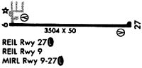
| Runway 09/27 | 4004 ft x 60 ft (1220 m x 18 m) | |
| Runway Length Source: | 3RD PARTY SURVEY as of 10/22/2014 | |
| Surface: | Concrete - Good condition - No special surface treatment | |
| Runway Edge Lights: | High Intensity | |
Runway 09 |
Runway 27 |
|
Elevation: |
699.0 | 698.6 |
Latitude: |
40-45-31.5632N | 40-45-31.3816N |
Longitude: |
087-26-10.8631W | 087-25-18.8390W |
|
Runway True Alignment: |
090 | 270 |
Glide Path Angle: |
3.0 degrees | 3.0 degrees |
Runway Markings Type: |
Nonprecision Instrument | Nonprecision Instrument |
Runway Markings Condition: |
Fair | Fair |
Object at End: |
CROPS | CROPS |
Object Height: |
10 | 10 |
Distance from End: |
230 | 201 |
Object Centerline Offset: |
0 ft. left and right of centerline | 0 ft. left and right of centerline |
Visual Glide Slope Indicators: |
2-Light PAPI On Left Side Of Runway | 2-Light PAPI On Left Side Of Runway |
REIL: |
Yes | Yes |
Threshold Crossing Height: |
40 | 45 |
Services
Airframe Repair: |
None |
Powerplant Repair: |
None |
Bottled Oxygen: |
None |
Bulk Oxygen: |
None |
Fuel Available: |
100LL, Jet A |
Landing Fees: |
No |
Parking: |
Hangars and tiedowns available |
Maps & Diagrams
KKT Sectional
Flight Planning
at skyvector.com
at skyvector.com