Location
Latitude: |
37-09-48.0900N (37.163358) |
Longitude: |
101-22-14.4390W (-101.370678) |
Elevation: |
3134.3 feet MSL (955 m MSL) |
Magnetic Variation: |
5.5 E (as of April 2024 from WMM2020 model) |
Time Zone: |
UTC -6.0 (Standard Time) UTC -5.0 (Daylight Savings Time) |
From City: |
02 N.M. SW of Hugoton, Kansas |
Found On: |
Wichita Chart |
FAA Region: |
ACE |
Contacts
Manager: |
Publicly owned: |
| SCOTT SPIKES BOX 130 HUGOTON, KS 67951 620-544-7600 |
STEVENS COUNTY P.O. BOX 130 HUGOTON, KS 67951 (620) 544-6331 |
Operations
Airport Status: |
Operational |
Facility Use: |
Public |
Type: |
Airport |
Activation Date: |
12/1946 |
Control tower: |
No |
Attendance (Months/Days/Hours): |
Months/Days/Hours ALL/MON-FRI/0800-1700 |
Boundary ARTCC: |
ZKC (Kansas City) |
Responsible ARTCC: |
ZKC (Kansas City) |
Lighting Schedule: |
SEE RMK |
Segmented Circle Indicator: |
Yes |
Traffic Pattern Altitude (MSL): |
4134 feet (1260 m) |
NOTAMs Facility: |
ICT |
NOTAM-D Service: |
Yes |
International Airport of Entry: |
No |
Customs Landing Rights: |
No |
Military Landing Rights: |
Yes |
Civil/Military Joint Use: |
No |
Based Aircraft
| Single Engine: | 12 |
Annual Operations (as of 06/14/2022)
| Total Operations: | 10000 | |
| GA Local: | 8000 | 80.0% |
| GA Itinerant: | 2000 | 20.0% |
Communications
| CTAF: | 122.800 |
| Unicom: | 122.800 |
| AWOS-3PT: | 118.600 (620-544-4000) |
- APCH/DEP CTL SVC PRVDD BY KANSAS CITY ARTCC (ZKC) ON FREQS 134.0/257.625 (LIBERAL RCAG).
Fixed Based Operators (FBOs) & Fuel
(Click on a business for detail)
Please help us keep this information up to date. This is a FREE SERVICE just like everything else on Airport Guide! If you see that a business needs to be added, modified, or deleted please fill out our Update Form.
To add, modify, or delete a business click here.
Please help us keep this information up to date. This is a FREE SERVICE just like everything else on Airport Guide! If you see that a business needs to be added, modified, or deleted please fill out our Update Form.
Area Code: 620 |
| Business Name | Frequency | Phone | Fuel Grade |
|---|
Flight Service Stations
| Primary | Alternate | |
| FSS on Field: | N | |
| FSS Name (ID): | Wichita(ICT) | |
| Frequency: | ||
| Toll Free Phone: | 1-800-WX-BRIEF |
Instrument Procedures / Charts
FAA Terminal Procedures valid from 0901Z 03/21/24 to 0901Z 04/18/24.
There are various types of charts available for an airport. They are listed in the Page Type column. Here is a legend for those types:
APD - Airport Diagram
DP - Departure Procedure Charts
HOT - Hot Spots
IAP - Instrument Approach Procedure Charts
MIN - Minimums
STAR - Standard Terminal Arrival Charts
| Page Type | Page Name | Volume | Action Since Last Cycle |
|---|---|---|---|
| IAP | RNAV (GPS) RWY 02 | NC-2 | |
| IAP | RNAV (GPS) RWY 20 | NC-2 | |
| MIN | ALTERNATE MINIMUMS | NC-2 | |
| MIN | TAKEOFF MINIMUMS | NC-2 |
Terminal Procedures are only available for airports in several countries with more being added all the time. If you are looking for a specific country's charts, please send an email to support(at)airportguide.com stating the country name. This will be used to prioritize the implementation.
Navigation Aids (Navaids) near KHQG
| Dist (NM) | ID | Morse Code | Name | Type | Freq | True Hdg | Mag Hdg |
|---|---|---|---|---|---|---|---|
| 0.2 | HQG | . . . . _ _ . _ _ _ . | Hugoton | NDB | 365 | 274 | 269 |
| 20.4 | LBL | . _ . . _ . . . . _ . . | Liberal | TACAN | 112.30 | 110 | 105 |
| 23.1 | LB | . _ . . _ . . . | Panck | NDB | 383 | 120 | 115 |
| 26.0 | ULS | . . _ . _ . . . . . | Ulysses | NDB | 395 | 0 | 355 |
| 26.5 | EHA | . . . . . . _ | Elkhart | NDB | 377 | 248 | 242 |
| 28.2 | GUY | _ _ . . . _ _ . _ _ | Guymon | NDB | 275 | 193 | 188 |
| 33.2 | JHN | . _ _ _ . . . . _ . | Bear Creek | NDB | 341 | 328 | 322 |
| 50.4 | GC | _ _ . _ . _ . | Pieve | NDB | 347 | 37 | 32 |
| 54.1 | PYX | . _ _ . _ . _ _ _ . . _ | Perryton | NDB | 266 | 146 | 141 |
| 54.8 | GCK | _ _ . _ . _ . _ . _ | Garden City | VORTAC | 113.30 | 33 | 28 |
| 77.0 | DDC | _ . . _ . . _ . _ . | Dodge City | VORTAC | 108.20 | 57 | 52 |
| 81.4 | BGD | _ . . . _ _ . _ . . | Borger | TACAN | 108.60 | 180 | 175 |
| 82.2 | TQK | _ _ _ . _ _ . _ | Scott City | NDB | 256 | 15 | 10 |
| 85.6 | DHT | _ . . . . . . _ | Dalhart | VORTAC | 112.00 | 221 | 215 |
| 85.8 | BFK | _ . . . . . _ . _ . _ | Buffalo | NDB | 215 | 101 | 96 |
| 86.9 | MMB | _ _ _ _ _ . . . | Mitbee | VORTAC | 115.60 | 124 | 119 |
| 88.1 | LAA | . _ . . . _ . _ | Lamar | VOR-DME | 116.90 | 315 | 309 |
| 94.8 | PPA | . _ _ . . _ _ . . _ | Pampa | NDB | 368 | 168 | 163 |
| 95.7 | CAO | _ . _ . . _ _ _ _ | Clayton | NDB | 332 | 243 | 237 |
Nearby Airports with Fuel
Notices to Airmen (NOTAMS)
Remarks
| A110*G | THIS AIRPORT HAS BEEN SURVEYED BY THE NATIONAL GEODETIC SURVEY. |
| A110-1 | FOR CD CTC KANSAS CITY ARTCC AT 913-254-8508. |
| A14 | ROBERT DAVIS CHMN ARPT BOARD. |
| A16 | 620-428-2044 |
| A17 | ON CALL 24 HRS AT 620-544-7600. |
| A51-31 | DSPLCD THLD PAINTED. |
| A75 | 4 TIE DOWN LOCATIONS |
| A81-APT | ACTVT HIRL RY 02/20; AND PAPI RYS 02 & 20 - CTAF. |
| E111 | MAINT APCHS 20:1 GLIDE SLOPE; TRSNL SFC FOR 7:1 SLOPE; AND REMOVE 13' BLDG LOCATED 100' FM RWY 31 THR AND 30' LEFT OF CNTRLN. |
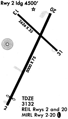
Runways
Runway Summary
| Runways: | 02/20 13/31 |
| Longest Runway: | 02/20 is 5000 ft (1524 m) long |
| Runways with an Instrument Approach: |
KHQG Airport Runway Details
| Runway 02/20 | 5000 ft x 75 ft (1524 m x 23 m) | |
| Runway Length Source: | 3RD PARTY SURVEY as of 11/15/2019 | |
| Surface: | Concrete - Fair condition - No special surface treatment | |
| Runway Pavement Class: | 11 /R/C/X/U | |
| Runway Edge Lights: | High Intensity | |
Runway Weight Bearing Capacity (in thousands of pounds) |
||
| Single Wheel Landing Gear: | 30.0 | |
Runway 02 |
Runway 20 |
|
Elevation: |
3133.4 | 3129.7 |
Latitude: |
37-09-19.9927N | 37-10-04.9202N |
Longitude: |
101-22-28.3565W | 101-22-02.5969W |
|
Runway True Alignment: |
025 | 205 |
Glide Path Angle: |
3.0 degrees | 3.0 degrees |
Traffic Pattern: |
Left | Left |
Runway Markings Type: |
Nonprecision Instrument | Nonprecision Instrument |
Runway Markings Condition: |
Good | Good |
Object at End: |
ROAD | ROAD |
Object Height: |
17 | 20 |
Distance from End: |
758 | 731 |
Object Centerline Offset: |
0 ft. left and right of centerline | 0 ft. left and right of centerline |
Visual Glide Slope Indicators: |
2-Light PAPI On Left Side Of Runway | 2-Light PAPI On Left Side Of Runway |
REIL: |
No | No |
Threshold Crossing Height: |
29 | 29 |
| Runway 13/31 | 3039 ft x 60 ft (926 m x 18 m) | |
| Runway Length Source: | 3RD PARTY SURVEY as of 11/15/2019 | |
| Surface: | Concrete - Fair condition - No special surface treatment | |
| Runway Pavement Class: | 5 /F/C/Y/U | |
Runway 13 |
Runway 31 |
|
Elevation: |
3129.4 | 3127.7 |
Latitude: |
37-10-08.0099N | 37-09-46.7033N |
Longitude: |
101-22-25.9654W | 101-21-59.4935W |
|
Runway True Alignment: |
135 | 315 |
Glide Path Angle: |
0.0 degrees | 0.0 degrees |
Runway Markings Type: |
Basic | Basic |
Runway Markings Condition: |
Good | Good |
Object at End: |
ROAD | TOWER |
Object Height: |
17 | 12 |
Distance from End: |
503 | 205 |
Object Centerline Offset: |
0 ft. left and right of centerline | 0 ft. left and right of centerline |
Threshold Elevation: |
3133.7 | 3128.7 |
Displaced Threshold: |
412 | 202 |
Threshold Latitude: |
37-10-05.1159N | 37-09-48.1209N |
Threshold Longitude: |
101-22-22.3775W | 101-22-01.2503W |
Services
Fuel Available: |
100LL, Jet A |
Landing Fees: |
No |
Parking: |
Tiedowns available |
Maps & Diagrams
KHQG Sectional
Flight Planning
at skyvector.com
at skyvector.com