Location
Latitude: |
43-31-19.3000N (43.522028) |
Longitude: |
089-46-16.5000W (-89.77125) |
Elevation: |
979.3 feet MSL (298 m MSL) |
Magnetic Variation: |
2.7 W (as of April 2024 from WMM2020 model) |
Time Zone: |
UTC -6.0 (Standard Time) UTC -5.0 (Daylight Savings Time) |
From City: |
03 N.M. NW of Baraboo, Wisconsin |
Found On: |
Chicago Chart |
FAA Region: |
AGL |
Contacts
Manager: |
Publicly owned: |
| CASEY BRADLEY 101 SOUTH BLVD BARABOO, WI 53913 608-355-2715 |
AIRPORT COMMISSION 101 SOUTH BLVD BARABOO, WI 53913 608-355-2700 |
Operations
Airport Status: |
Operational |
Facility Use: |
Public |
Type: |
Airport |
Activation Date: |
10/1945 |
Control tower: |
No |
Attendance (Months/Days/Hours): |
Months/Days/Hours MAY-SEP/ALL/0800-1900 |
Boundary ARTCC: |
ZAU (Chicago) |
Responsible ARTCC: |
ZAU (Chicago) |
Lighting Schedule: |
SEE RMK |
Segmented Circle Indicator: |
Yes |
Traffic Pattern Altitude (MSL): |
1979 feet (603 m) |
NOTAMs Facility: |
DLL |
NOTAM-D Service: |
Yes |
International Airport of Entry: |
No |
Customs Landing Rights: |
No |
Military Landing Rights: |
Yes |
Civil/Military Joint Use: |
No |
Based Aircraft
| Single Engine: | 43 |
| Multi Engine: | 3 |
| Jet Engine: | 3 |
| Gliders: | 1 |
Annual Operations (as of 04/09/2021)
| Total Operations: | 30000 | |
| Air Taxi: | 1000 | 3.3% |
| GA Local: | 7500 | 25.0% |
| GA Itinerant: | 19000 | 63.3% |
| Military Aircraft: | 2500 | 8.3% |
Communications
| CTAF: | 123.050 |
| Unicom: | 123.050 |
| Approach: | MADISON 135.45 135.45 CHICAGO ARTCC |
| Departure: | MADISON 135.45 135.45 CHICAGO ARTCC |
| AWOS-3: | 118.325 (608-356-1071) |
- APCH/DEP SVC PRVDD BY CHICAGO ARTCC ON FREQS 133.3/257.925 (LONE ROCK RCAG) WHEN MADISON APCH CTL CLSD.
Fixed Based Operators (FBOs) & Fuel
(Click on a business for detail)
Please help us keep this information up to date. This is a FREE SERVICE just like everything else on Airport Guide! If you see that a business needs to be added, modified, or deleted please fill out our Update Form.
To add, modify, or delete a business click here.
Please help us keep this information up to date. This is a FREE SERVICE just like everything else on Airport Guide! If you see that a business needs to be added, modified, or deleted please fill out our Update Form.
Area Code: 608 |
| Business Name | Frequency | Phone | Fuel Grade |
|---|---|---|---|
| Baraboo Dells Flight Center, Inc.
Update FBO info |
Unicom 123.0 | 356-2270, in emergency call 253-7997 | 80, 100LL, Jet A |
Flight Service Stations
| Primary | Alternate | |
| FSS on Field: | N | |
| FSS Name (ID): | Green Bay(GRB) | |
| Frequency: | ||
| Toll Free Phone: | 1-800-WX-BRIEF |
Instrument Procedures / Charts
FAA Terminal Procedures valid from 0901Z 03/21/24 to 0901Z 04/18/24.
There are various types of charts available for an airport. They are listed in the Page Type column. Here is a legend for those types:
APD - Airport Diagram
DP - Departure Procedure Charts
HOT - Hot Spots
IAP - Instrument Approach Procedure Charts
MIN - Minimums
STAR - Standard Terminal Arrival Charts
| Page Type | Page Name | Volume | Action Since Last Cycle |
|---|---|---|---|
| IAP | LOC RWY 01 | EC-3 | |
| IAP | RNAV (GPS) RWY 01 | EC-3 | |
| IAP | RNAV (GPS) RWY 19 | EC-3 | |
| IAP | VOR-A | EC-3 | |
| MIN | ALTERNATE MINIMUMS | EC-3 | |
| MIN | TAKEOFF MINIMUMS | EC-3 |
Terminal Procedures are only available for airports in several countries with more being added all the time. If you are looking for a specific country's charts, please send an email to support(at)airportguide.com stating the country name. This will be used to prioritize the implementation.
Navigation Aids (Navaids) near KDLL
| Dist (NM) | ID | Morse Code | Name | Type | Freq | True Hdg | Mag Hdg |
|---|---|---|---|---|---|---|---|
| 1.8 | DLL | _ . . . _ . . . _ . . | Dells | VORTAC | 117.00 | 10 | 13 |
| 20.9 | LNR | . _ . . _ . . _ . | Lone Rock | DME | 116.05 | 229 | 232 |
| 25.7 | HBW | . . . . _ . . . . _ _ | Kickapoo | NDB | 251 | 288 | 291 |
| 29.4 | MSN | _ _ . . . _ . | Madison | VORTAC | 108.60 | 140 | 143 |
| 32.9 | VOK | . . . _ _ _ _ _ . _ | Volk | TACAN | 110.40 | 320 | 323 |
| 33.2 | MS | _ _ . . . | Monah | NDB | 400 | 145 | 148 |
| 42.9 | MRJ | _ _ . _ . . _ _ _ | Mineral Point | NDB | 365 | 207 | 210 |
| 44.6 | EK | . _ . _ | Nepco | NDB | 326 | 353 | 356 |
| 45.2 | CMY | _ . _ . _ _ _ . _ _ | Mccoy | NDB | 412 | 303 | 305 |
| 46.9 | UNU | . . _ _ . . . _ | Juneau | NDB | 344 | 96 | 99 |
| 50.2 | RYV | . _ . _ . _ _ . . . _ | Rock River | NDB | 371 | 114 | 117 |
| 50.6 | ISW | . . . . . . _ _ | Wisconsin Rapids | NDB | 215 | 356 | 359 |
| 56.7 | OS | _ _ _ . . . | Pober | NDB | 395 | 67 | 70 |
| 58.6 | PCZ | . _ _ . _ . _ . _ _ . . | Waupaca | NDB | 382 | 33 | 36 |
| 59.7 | OSH | _ _ _ . . . . . . . | Oshkosh | VORTAC | 116.75 | 61 | 64 |
| 62.1 | STE | . . . _ . | Stevens Point | VORTAC | 110.60 | 9 | 12 |
| 63.1 | JVL | . _ _ _ . . . _ . _ . . | Janesville | NDB | 375 | 149 | 152 |
| 64.1 | BCK | _ . . . _ . _ . _ . _ | Black River Falls | NDB | 362 | 313 | 315 |
| 64.1 | AT | . _ _ | Gamie | NDB | 230 | 52 | 55 |
| 64.8 | JVL | . _ _ _ . . . _ . _ . . | Janesville | VOR-DME | 114.30 | 152 | 155 |
Nearby Airports with Fuel
Notices to Airmen (NOTAMS)
Remarks
| A11 | CITY OF BARABOO; CITY OF WISCONSIN DELLS - TOWN & VILLAGE OF LAKE DELTON. |
| A110-2 | BIRDS ON & INVOF ARPT IN FALL. |
| A110-3 | FOR CD CTC MADISON APP/DEP CON AT 608-249-8240. WHEN MADISON APCH CLSD, FOR CD CTC CHICAGO ARTCC AT 630-906-8921. |
| A110-4 | RWY 14/32 NOT PLWD & CLSD NOV 15 THRU APR 15; CFM STS CTC - 608-356-2270. |
| A110-5 | NOISE ABATEMENT: AVOID OVERFLIGHT OF WILDLIFE SANCTUARY 1.5 NM NE. |
| A42-14 | MKD WITH YELLOW/BLACK A-FRAMES AND YELLOW CONES. |
| A42-32 | MKD WITH YELLOW/BLACK A-FRAMES AND YELLOW CONES. |
| A43-01 | PAPI UNUSBL BYD 8 DEGS LEFT OF CNTRLN. |
| A70-FUEL-10 | 0LL 24 HR FUEL AVBL WITH CREDIT CARD. |
| A81-APT | ACTVT REIL RWY 01 & 19; PAPI RWY 01 & 19 - CTAF. MIRL RWY 01/19 PRESET ON LOW INTST, TO INCR INTST & ACTVT - CTAF. |
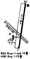
Runways
Runway Summary
| Runways: | 01/19 14/32 |
| Longest Runway: | 01/19 is 5010 ft (1527 m) long |
| Runways with an Instrument Approach: | 01 |
KDLL Airport Runway Details
| Runway 01/19 | 5010 ft x 100 ft (1527 m x 30 m) | |
| Runway Length Source: | 3RD PARTY SURVEY as of 12/22/2011 | |
| Surface: | Asphalt - Excellent condition - No special surface treatment | |
| Runway Edge Lights: | Medium Intensity | |
Runway Weight Bearing Capacity (in thousands of pounds) |
||
| Single Wheel Landing Gear: | 30.0 | |
| Dual Wheel Landing Gear: | 55.0 | |
Runway 01 |
Runway 19 |
|
Elevation: |
976.8 | 967.2 |
Latitude: |
43-30-56.1438N | 43-31-45.0439N |
Longitude: |
089-46-18.2942W | 089-46-07.9251W |
|
Runway True Alignment: |
009 | 189 |
ILS Type: |
LOC/DME | |
Glide Path Angle: |
3.0 degrees | 3.0 degrees |
Traffic Pattern: |
Left | Left |
Runway Markings Type: |
Nonprecision Instrument | Nonprecision Instrument |
Runway Markings Condition: |
Good | Good |
Object at End: |
TREES | |
Object Height: |
134 | |
Distance from End: |
3820 | |
Object Centerline Offset: |
580 ft. left of centerline | |
Visual Glide Slope Indicators: |
2-Light PAPI On Left Side Of Runway | 2-Light PAPI On Left Side Of Runway |
REIL: |
Yes | Yes |
Touchdown Lights: |
No | No |
Centerline Lights: |
No | No |
Threshold Crossing Height: |
32 | 32 |
| Runway 14/32 | 2746 ft x 100 ft (837 m x 30 m) | |
| Runway Length Source: | 3RD PARTY SURVEY as of 12/22/2011 | |
| Surface: | Asphalt - Excellent condition - No special surface treatment | |
Runway 14 |
Runway 32 |
|
Elevation: |
971.8 | 977.2 |
Latitude: |
43-31-26.2896N | 43-31-07.4362N |
Longitude: |
089-46-36.0078W | 089-46-09.2276W |
|
Runway True Alignment: |
134 | 314 |
Glide Path Angle: |
0.0 degrees | 0.0 degrees |
Traffic Pattern: |
Left | Left |
Runway Markings Type: |
None | None |
Object at End: |
TREE | |
Object Height: |
78 | |
Distance from End: |
1330 | |
Object Centerline Offset: |
580 ft. left of centerline | |
REIL: |
No | No |
Touchdown Lights: |
No | No |
Centerline Lights: |
No | No |
Services
Fuel Available: |
100LL |
Landing Fees: |
No |
Parking: |
Hangars available |
Maps & Diagrams
KDLL Sectional
Flight Planning
at skyvector.com
at skyvector.com