Location
Latitude: |
39-23-13.7000N (39.387139) |
Longitude: |
097-09-26.0000W (-97.157222) |
Elevation: |
1208.9 feet MSL (368 m MSL) |
Magnetic Variation: |
3 E (as of April 2024 from WMM2020 model) |
Time Zone: |
UTC -6.0 (Standard Time) UTC -5.0 (Daylight Savings Time) |
From City: |
02 N.M. W of Clay Center, Kansas |
Found On: |
Wichita Chart |
FAA Region: |
ACE |
Contacts
Manager: |
Publicly owned: |
| SCOTT HEINEN 1226 104TH ROAD SENECA, KS 66538 (800) 760-4964 |
CITY OF CLAY CENTER 427 COURT ST. CLAY CENTER, KS 67432 785-632-5454 |
Operations
Airport Status: |
Operational |
Facility Use: |
Public |
Type: |
Airport |
Activation Date: |
04/1942 |
Control tower: |
No |
Attendance (Months/Days/Hours): |
Months/Days/Hours ALL/ALL/0800-1700 |
Boundary ARTCC: |
ZKC (Kansas City) |
Responsible ARTCC: |
ZKC (Kansas City) |
Lighting Schedule: |
SEE RMK |
Segmented Circle Indicator: |
Yes |
Traffic Pattern Altitude (MSL): |
2209 feet (673 m) |
NOTAMs Facility: |
ICT |
NOTAM-D Service: |
Yes |
International Airport of Entry: |
No |
Customs Landing Rights: |
No |
Civil/Military Joint Use: |
No |
Based Aircraft
| Single Engine: | 12 |
Annual Operations (as of 10/24/2022)
| Total Operations: | 31000 | |
| GA Local: | 12000 | 38.7% |
| GA Itinerant: | 10000 | 32.3% |
| Military Aircraft: | 9000 | 29.0% |
Communications
| CTAF: | 122.800 |
| Unicom: | 122.800 |
| Approach: | MARSHALL AAF GCA 121.25 121.25 KANSAS CITY ARTCC |
| Departure: | MARSHALL AAF GCA 121.25 121.25 KANSAS CITY ARTCC |
| AWOS-3T: | 119.95 (785-777-2507) |
- APCH/DEP CTL SVC PRVDD BY KANSAS CITY ARTCC (ZKC) ON FREQS 127.35/257.975 (MANHATTAN RCAG) WHEN MARSHALL APCH CTL (FRI) CLSD.
Fixed Based Operators (FBOs) & Fuel
(Click on a business for detail)
Please help us keep this information up to date. This is a FREE SERVICE just like everything else on Airport Guide! If you see that a business needs to be added, modified, or deleted please fill out our Update Form.
To add, modify, or delete a business click here.
Please help us keep this information up to date. This is a FREE SERVICE just like everything else on Airport Guide! If you see that a business needs to be added, modified, or deleted please fill out our Update Form.
Area Code: 785 |
| Business Name | Frequency | Phone | Fuel Grade |
|---|---|---|---|
| Spicer Aircraft, Inc.
Update FBO info |
Unicom 122.8 | 632-3217 | 100LL, MOGAS |
Flight Service Stations
| Primary | Alternate | |
| FSS on Field: | N | |
| FSS Name (ID): | Wichita(ICT) | |
| Frequency: | ||
| Toll Free Phone: | 1-800-WX-BRIEF |
Instrument Procedures / Charts
FAA Terminal Procedures valid from 0901Z 03/21/24 to 0901Z 04/18/24.
There are various types of charts available for an airport. They are listed in the Page Type column. Here is a legend for those types:
APD - Airport Diagram
DP - Departure Procedure Charts
HOT - Hot Spots
IAP - Instrument Approach Procedure Charts
MIN - Minimums
STAR - Standard Terminal Arrival Charts
| Page Type | Page Name | Volume | Action Since Last Cycle |
|---|---|---|---|
| IAP | RNAV (GPS) RWY 17 | NC-2 | |
| IAP | RNAV (GPS) RWY 35 | NC-2 | |
| MIN | TAKEOFF MINIMUMS | NC-2 |
Terminal Procedures are only available for airports in several countries with more being added all the time. If you are looking for a specific country's charts, please send an email to support(at)airportguide.com stating the country name. This will be used to prioritize the implementation.
Navigation Aids (Navaids) near KCYW
| Dist (NM) | ID | Morse Code | Name | Type | Freq | True Hdg | Mag Hdg |
|---|---|---|---|---|---|---|---|
| 0.4 | CYW | _ . _ . _ . _ _ . _ _ | Clay Center | NDB | 362 | 206 | 203 |
| 25.0 | CNK | _ . _ . _ . _ . _ | Concordia | NDB | 335 | 293 | 290 |
| 26.9 | MHK | _ _ . . . . _ . _ | Manhattan | VOR-DME | 110.20 | 122 | 119 |
| 27.5 | CVY | _ . _ . . . . _ _ . _ _ | Cavalry | NDB | 314 | 141 | 138 |
| 28.6 | FRI | . . _ . . _ . . . | Fort Riley | VOR | 109.40 | 151 | 148 |
| 34.5 | RPB | . _ . . _ _ . _ . . . | Republican | NDB | 414 | 318 | 315 |
| 35.1 | SLN | . . . . _ . . _ . | Salina | VORTAC | 117.10 | 218 | 215 |
| 44.7 | HRU | . . . . . _ . . . _ | Herington | NDB | 407 | 158 | 155 |
| 47.4 | FBY | . . _ . _ . . . _ . _ _ | Fairbury | NDB | 293 | 359 | 356 |
| 48.1 | SL | . . . . _ . . | Flory | NDB | 344 | 208 | 205 |
| 49.9 | HJH | . . . . . _ _ _ . . . . | Hebron | NDB | 323 | 336 | 333 |
| 56.9 | TKO | _ _ . _ _ _ _ | Mankato | VORTAC | 109.80 | 296 | 293 |
| 57.9 | BIE | _ . . . . . . | Beatrice | VOR | 110.60 | 18 | 15 |
| 65.6 | PWE | . _ _ . . _ _ . | Pawnee City | DME | 112.4 | 41 | 38 |
| 67.1 | MPR | _ _ . _ _ . . _ . | Mc Pherson | NDB | 227 | 201 | 198 |
| 70.2 | TO | _ _ _ _ | Biloy | NDB | 521 | 102 | 100 |
| 74.1 | FOE | . . _ . _ _ _ . | Forbes | VOT | 111.00 | 110 | 108 |
| 74.4 | FOE | . . _ . _ _ _ . | Forbes | TACAN | 111.60 | 110 | 108 |
| 74.6 | FMZ | . . _ . _ _ _ _ . . | Beklof | NDB | 392 | 345 | 342 |
| 74.7 | CA | _ . _ . . _ | Harvs | NDB | 395 | 184 | 181 |
Nearby Airports with Fuel
Notices to Airmen (NOTAMS)
Remarks
| A110-1 | FOR CD CTC MARSHALL APCH AT 785-239-2118. WHEN MARSHALL APCH IS CLSD, CTC KANSAS CITY ARTCC AT 913-254-8508. |
| A17 | FOR SVC AFT DUSK CALL CELL 785-757-4551. |
| A52-17 | CROPS AND PIVOT IRRIGATION EQUIPMENT IN CLOSE PROXIMITY OF AER 17. |
| A57-17 | RWY 17 22:1 TO DSPLCD THR. |
| A81-APT | RY 17/35 MIRL PRESET LOW INTST DUSK-2200; TO INCR INTST ACTVT - CTAF. AFT 2200 ACTVT - CTAF. ACTIVE REILS AND PAPIS - CTAF. RWY 17/35 ACTVT REILS AND PAPIS -CTAF. |
Runways
Runway Summary
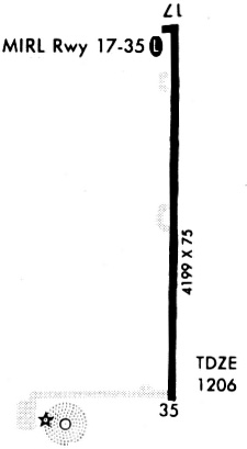
| Runways: | 17/35 |
| Longest Runway: | 17/35 is 4197 ft (1279 m) long |
| Runways with an Instrument Approach: |
KCYW Airport Runway Details
| Runway 17/35 | 4197 ft x 75 ft (1279 m x 23 m) | |
| Runway Length Source: | 3RD PARTY SURVEY as of 08/31/2016 | |
| Surface: | Asphalt - Fair condition - No special surface treatment | |
| Runway Pavement Class: | 6 /F/C/Y/U | |
| Runway Edge Lights: | Medium Intensity | |
Runway Weight Bearing Capacity (in thousands of pounds) |
||
| Single Wheel Landing Gear: | 12.0 | |
| Dual Wheel Landing Gear: | 15.0 | |
Runway 17 |
Runway 35 |
|
Elevation: |
1208.7 | 1206.7 |
Latitude: |
39-23-34.4162N | 39-22-52.9554N |
Longitude: |
097-09-25.3504W | 097-09-26.5891W |
|
Runway True Alignment: |
181 | 001 |
Glide Path Angle: |
2.8 degrees | 2.8 degrees |
Traffic Pattern: |
Left | Left |
Runway Markings Type: |
Numbers Only | Numbers Only |
Runway Markings Condition: |
Fair | Fair |
Object at End: |
TREE | POLE |
Object Height: |
26 | 36 |
Distance from End: |
853 | 634 |
Object Centerline Offset: |
349 ft. left of centerline | 453 ft. left and right of centerline |
Visual Glide Slope Indicators: |
2-Light PAPI On Left Side Of Runway | 2-Light PAPI On Left Side Of Runway |
REIL: |
Yes | Yes |
Threshold Crossing Height: |
39 | 39 |
Threshold Elevation: |
1208.7 | 1206.8 |
Displaced Threshold: |
202 | 227 |
Threshold Latitude: |
39-23-32.4204N | 39-22-55.2008N |
Threshold Longitude: |
097-09-25.4123W | 097-09-26.5221W |
Services
Airframe Repair: |
None |
Powerplant Repair: |
None |
Bottled Oxygen: |
None |
Bulk Oxygen: |
None |
Fuel Available: |
100LL |
Landing Fees: |
No |
Parking: |
Tiedowns available |
Maps & Diagrams
KCYW Sectional
Flight Planning
at skyvector.com
at skyvector.com