Location
Latitude: |
41-16-28.9000N (41.274694) |
Longitude: |
085-50-24.3000W (-85.840083) |
Elevation: |
849.7 feet MSL (259 m MSL) |
Magnetic Variation: |
5.4 W (as of April 2024 from WMM2020 model) |
Time Zone: |
UTC -5.0 (Standard Time) UTC -4.0 (Daylight Savings Time) |
From City: |
02 N.M. N of Warsaw, Indiana |
Found On: |
Chicago Chart |
FAA Region: |
AGL |
Contacts
Manager: |
Publicly owned: |
| NICHOLAS KING 3000 AIRPORT DR WARSAW, IN 46582 574-269-1337 |
WARSAW BOAC 3000 AIRPORT DR WARSAW, IN 46582 574-269-1337 |
Operations
Airport Status: |
Operational |
Facility Use: |
Public |
Type: |
Airport |
Activation Date: |
09/1947 |
Control tower: |
No |
Attendance (Months/Days/Hours): |
Months/Days/Hours ALL/MON-FRI/0700-1900 |
Boundary ARTCC: |
ZAU (Chicago) |
Responsible ARTCC: |
ZAU (Chicago) |
Lighting Schedule: |
SEE RMK |
Segmented Circle Indicator: |
Yes |
Traffic Pattern Altitude (MSL): |
1850 feet (564 m) |
NOTAMs Facility: |
ASW |
NOTAM-D Service: |
Yes |
International Airport of Entry: |
No |
Customs Landing Rights: |
No |
Military Landing Rights: |
Yes |
Civil/Military Joint Use: |
No |
Based Aircraft
| Single Engine: | 36 |
| Multi Engine: | 2 |
| Jet Engine: | 3 |
| GA Helicopters: | 2 |
Annual Operations (as of 12/31/2019)
| Total Operations: | 13373 | |
| Air Taxi: | 669 | 5.0% |
| GA Local: | 8960 | 67.0% |
| GA Itinerant: | 3744 | 28.0% |
Communications
| CTAF: | 122.700 |
| Unicom: | 122.700 |
| Approach: | FORT WAYNE 127.2 127.2 127.2 |
| Departure: | FORT WAYNE 127.2 127.2 127.2 |
| AWOS-3: | 121.125 (574-269-7035) |
- APCH CTL SECTORIZATION BASED UPON FORT WAYNE RWY USAGE.
Fixed Based Operators (FBOs) & Fuel
(Click on a business for detail)
Please help us keep this information up to date. This is a FREE SERVICE just like everything else on Airport Guide! If you see that a business needs to be added, modified, or deleted please fill out our Update Form.
To add, modify, or delete a business click here.
Please help us keep this information up to date. This is a FREE SERVICE just like everything else on Airport Guide! If you see that a business needs to be added, modified, or deleted please fill out our Update Form.
Area Code: 219 |
| Business Name | Frequency | Phone | Fuel Grade |
|---|---|---|---|
| Air Care, Inc.
Update FBO info |
269-5081 | ||
| Cheyenne Charter, Inc.
Update FBO info |
267-5558 | ||
| City Aviation Service
Update FBO info |
Unicom 122.7 | 269-1337 | 100LL, Jet A |
Flight Service Stations
| Primary | Alternate | |
| FSS on Field: | N | |
| FSS Name (ID): | Terre Haute(HUF) | |
| Frequency: | ||
| Toll Free Phone: | 1-800-WX-BRIEF |
Instrument Procedures / Charts
FAA Terminal Procedures valid from 0901Z 03/21/24 to 0901Z 04/18/24.
There are various types of charts available for an airport. They are listed in the Page Type column. Here is a legend for those types:
APD - Airport Diagram
DP - Departure Procedure Charts
HOT - Hot Spots
IAP - Instrument Approach Procedure Charts
MIN - Minimums
STAR - Standard Terminal Arrival Charts
| Page Type | Page Name | Volume | Action Since Last Cycle |
|---|---|---|---|
| IAP | ILS OR LOC RWY 27 | EC-2 | Changed |
| IAP | RNAV (GPS) RWY 09 | EC-2 | |
| IAP | RNAV (GPS) RWY 27 | EC-2 | |
| MIN | ALTERNATE MINIMUMS | EC-2 | |
| MIN | TAKEOFF MINIMUMS | EC-2 |
Terminal Procedures are only available for airports in several countries with more being added all the time. If you are looking for a specific country's charts, please send an email to support(at)airportguide.com stating the country name. This will be used to prioritize the implementation.
Navigation Aids (Navaids) near KASW
| Dist (NM) | ID | Morse Code | Name | Type | Freq | True Hdg | Mag Hdg |
|---|---|---|---|---|---|---|---|
| 15.5 | OLK | _ _ _ . _ . . _ . _ | Webster Lake | VOR | 110.40 | 96 | 102 |
| 17.2 | GSH | _ _ . . . . . . . . | Goshen | VORTAC | 113.70 | 330 | 335 |
| 24.8 | CPB | _ . _ . . _ _ . _ . . . | Culver | NDB | 391 | 262 | 267 |
| 30.4 | HHG | . . . . . . . . _ _ . | Huntington | NDB | 417 | 145 | 151 |
| 30.7 | IWH | . . . _ _ . . . . | Wabash | NDB | 329 | 176 | 181 |
| 31.0 | SB | . . . _ . . . | Misha | NDB | 341 | 326 | 331 |
| 34.3 | FWA | . . _ . . _ _ . _ | Fort Wayne Baer | VOT | 111.00 | 121 | 127 |
| 34.4 | FWA | . . _ . . _ _ . _ | Fort Wayne | VORTAC | 117.80 | 120 | 126 |
| 36.2 | RWN | . _ . . _ _ _ . | Winamac/Dcmsnd | NDB | 335 | 252 | 257 |
| 36.6 | OXI | _ _ _ _ . . _ . . | Knox | DME | 115.6 | 274 | 279 |
| 36.6 | GIJ | _ _ . . . . _ _ _ | Gipper | VORTAC | 115.40 | 324 | 329 |
| 37.1 | IRS | . . . _ . . . . | Sturgis | NDB | 382 | 29 | 35 |
| 40.3 | ANQ | . _ _ . _ _ . _ | Angola | NDB | 347 | 56 | 62 |
| 40.3 | GUS | _ _ . . . _ . . . | Grissom | VORTAC | 108.45 | 200 | 205 |
| 40.4 | GW | _ _ . . _ _ | Shenk | NDB | 227 | 86 | 92 |
| 42.5 | HAI | . . . . . _ . . | Three Rivers | NDB | 407 | 15 | 21 |
| 44.0 | IUL | . . . . _ . _ . . | La Porte | NDB | 356 | 288 | 293 |
| 45.9 | OKK | _ _ _ _ . _ _ . _ | Kokomo | TACAN | 113.50 | 192 | 197 |
| 47.4 | MZZ | _ _ _ _ . . _ _ . . | Marion | VOR-DME | 108.60 | 171 | 176 |
| 47.9 | VP | . . . _ . _ _ . | Sedly | NDB | 212 | 283 | 288 |
Nearby Airports with Fuel
Notices to Airmen (NOTAMS)
Remarks
| A110-1 | FOR CD CTC CHICAGO ARTCC AT 630-906-8921. |
| A17 | AFT HR - 574-372-9541 |
| A56-27 | CLOSEST ESTD INTCP OF TALLEST TWR. |
| A57-27 | APCH SLOPE 34:1 TO DTHR. |
| A58-27 | 6 FT FENCE 1045 FT FM RWY END; 15 FT ROAD 1070 FT FM RWY END. |
| A75 | PPR - AMGR. |
| A81-APT | ACTVT REIL RWY 09 & 27; PAPI RWY 09 & 27; MIRL RWY 18/36 - CTAF. VASI RWY 18 OPR CONSLY. HIRL RWY 09/27 PRESET TO LOW INTST; INCR INTST - CTAF. |
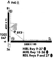
Runways
Runway Summary
| Runways: | 09/27 18/36 |
| Longest Runway: | 09/27 is 6001 ft (1829 m) long |
| Runways with an Instrument Approach: | 27 |
KASW Airport Runway Details
| Runway 09/27 | 6001 ft x 100 ft (1829 m x 30 m) | |
| Runway Length Source: | 3RD PARTY SURVEY as of 06/16/2017 | |
| Surface: | Asphalt - Good condition - Saw-cut or plastic grooved | |
| Runway Edge Lights: | High Intensity | |
Runway Weight Bearing Capacity (in thousands of pounds) |
||
| Single Wheel Landing Gear: | 46.0 | |
| Dual Wheel Landing Gear: | 75.0 | |
Runway 09 |
Runway 27 |
|
Elevation: |
837.4 | 849.5 |
Latitude: |
41-16-20.6680N | 41-16-21.8915N |
Longitude: |
085-50-46.4399W | 085-49-27.8661W |
|
Runway True Alignment: |
089 | 269 |
ILS Type: |
ILS/DME | |
Glide Path Angle: |
3.0 degrees | 3.0 degrees |
Runway Markings Type: |
Nonprecision Instrument | Precision Instrument |
Runway Markings Condition: |
Fair | Fair |
Object at End: |
POLE | TOWER |
Object Height: |
41 | 166 |
Object Marked/Lighted?: |
Lighted | |
Distance from End: |
1460 | 5600 |
Object Centerline Offset: |
10 ft. right of centerline | 200 ft. right of centerline |
Visual Glide Slope Indicators: |
2-Light PAPI On Left Side Of Runway | 4-Light PAPI On Left Side Of Runway |
REIL: |
Yes | Yes |
Threshold Crossing Height: |
27 | 54 |
Threshold Elevation: |
846.9 | |
Displaced Threshold: |
901 | |
Threshold Latitude: |
41-16-21.7086N | |
Threshold Longitude: |
085-49-39.6656W | |
Declared Distances |
||
Take Off Run Avbl. (TORA): |
5100 | 6000 |
Take Off Distance Avbl. (TODA): |
5100 | 6000 |
Actual Stop Dist. Avbl. (ASDA): |
5100 | 6000 |
Landing Dist. Avbl. (LDA): |
5100 | 5100 |
| Runway 18/36 | 4021 ft x 75 ft (1226 m x 23 m) | |
| Runway Length Source: | 3RD PARTY SURVEY as of 06/16/2017 | |
| Surface: | Asphalt - Good condition - No special surface treatment | |
| Runway Edge Lights: | Medium Intensity | |
Runway Weight Bearing Capacity (in thousands of pounds) |
||
| Single Wheel Landing Gear: | 15.0 | |
Runway 18 |
Runway 36 |
|
Elevation: |
839.7 | 836.5 |
Latitude: |
41-17-00.1970N | 41-16-20.4783N |
Longitude: |
085-50-50.1783W | 085-50-49.4271W |
|
Runway True Alignment: |
179 | 359 |
Glide Path Angle: |
3.5 degrees | 0.0 degrees |
Traffic Pattern: |
Left | Left |
Runway Markings Type: |
Nonprecision Instrument | Nonprecision Instrument |
Runway Markings Condition: |
Fair | Fair |
Object at End: |
ROAD | TREE |
Object Height: |
15 | 28 |
Distance from End: |
495 | 1000 |
Object Centerline Offset: |
10 ft. right of centerline | 200 ft. right of centerline |
Visual Glide Slope Indicators: |
4-Box VASI On Left Side Of Runway | |
Threshold Crossing Height: |
35 |
Services
Airframe Repair: |
Minor |
Powerplant Repair: |
Minor |
Bottled Oxygen: |
None |
Bulk Oxygen: |
None |
Fuel Available: |
100LL |
Landing Fees: |
No |
Parking: |
Hangars and tiedowns available |
Maps & Diagrams
KASW Sectional
Flight Planning
at skyvector.com
at skyvector.com