Location
Latitude: |
38-51-06.0210N (38.851673) |
Longitude: |
083-33-57.6260W (-83.566007) |
Elevation: |
896.0 feet MSL (273 m MSL) |
Magnetic Variation: |
6.7 W (as of April 2024 from WMM2020 model) |
Time Zone: |
UTC -5.0 (Standard Time) UTC -4.0 (Daylight Savings Time) |
From City: |
04 N.M. NW of West Union, Ohio |
Found On: |
Cincinnati Chart |
FAA Region: |
AGL |
Contacts
Manager: |
Publicly owned: |
| JASON GROOMS 3399 CROSS RD WINCHESTER, OH 45697-9477 513-550-2919 |
ADAMS CO ARPT AUTH ADAMS CO COURTHOUSE, 110 W MAIN ST WEST UNION, OH 45693-1347 937-544-3286 |
Operations
Airport Status: |
Operational |
Facility Use: |
Public |
Type: |
Airport |
Activation Date: |
03/1972 |
Control tower: |
No |
Attendance (Months/Days/Hours): |
Months/Days/Hours ALL/MON-FRI/IREG |
Boundary ARTCC: |
ZID (Indianapolis) |
Responsible ARTCC: |
ZID (Indianapolis) |
Lighting Schedule: |
SEE RMK |
Segmented Circle Indicator: |
No |
Traffic Pattern Altitude (MSL): |
1896 feet (578 m) |
NOTAMs Facility: |
DAY |
NOTAM-D Service: |
Yes |
Based Aircraft
| Single Engine: | 16 |
Annual Operations (as of 09/07/2021)
| Total Operations: | 1416 | |
| GA Local: | 1344 | 94.9% |
| GA Itinerant: | 72 | 5.1% |
Communications
| CTAF: | 122.800 |
| Unicom: | 122.800 |
- APCH/DEP SVC PRVDD BY INDIANAPOLIS ARTCC ON FREQS 135.575/290.5 (PORTSMOUTH RCAG).
Fixed Based Operators (FBOs) & Fuel
(Click on a business for detail)
Please help us keep this information up to date. This is a FREE SERVICE just like everything else on Airport Guide! If you see that a business needs to be added, modified, or deleted please fill out our Update Form.
To add, modify, or delete a business click here.
Please help us keep this information up to date. This is a FREE SERVICE just like everything else on Airport Guide! If you see that a business needs to be added, modified, or deleted please fill out our Update Form.
Area Code: 937 |
| Business Name | Frequency | Phone | Fuel Grade |
|---|
Flight Service Stations
| Primary | Alternate | |
| FSS on Field: | N | |
| FSS Name (ID): | Dayton(DAY) | |
| Frequency: | ||
| Toll Free Phone: | 1-800-WX-BRIEF |
Instrument Procedures / Charts
FAA Terminal Procedures valid from 0901Z 03/21/24 to 0901Z 04/18/24.
There are various types of charts available for an airport. They are listed in the Page Type column. Here is a legend for those types:
APD - Airport Diagram
DP - Departure Procedure Charts
HOT - Hot Spots
IAP - Instrument Approach Procedure Charts
MIN - Minimums
STAR - Standard Terminal Arrival Charts
| Page Type | Page Name | Volume | Action Since Last Cycle |
|---|---|---|---|
| IAP | RNAV (GPS) RWY 05 | EC-2 | |
| IAP | RNAV (GPS) RWY 23 | EC-2 | |
| MIN | TAKEOFF MINIMUMS | EC-2 |
Terminal Procedures are only available for airports in several countries with more being added all the time. If you are looking for a specific country's charts, please send an email to support(at)airportguide.com stating the country name. This will be used to prioritize the implementation.
Navigation Aids (Navaids) near KAMT
| Dist (NM) | ID | Morse Code | Name | Type | Freq | True Hdg | Mag Hdg |
|---|---|---|---|---|---|---|---|
| 0.2 | AMT | . _ _ _ _ | West Union | NDB | 359 | 24 | 31 |
| 11.9 | PZO | . _ _ . _ _ . . _ _ _ | Peebles | NDB | 329 | 69 | 76 |
| 17.1 | XW | _ . . _ . _ _ | Flmng | NDB | 400 | 192 | 199 |
| 20.0 | HOC | . . . . _ _ _ _ . _ . | Hillsboro | NDB | 278 | 3 | 10 |
| 30.2 | YRK | _ . _ _ . _ . _ . _ | York | VORTAC | 112.80 | 114 | 121 |
| 33.2 | PWF | . _ _ . . _ _ . . _ . | Sportys | NDB | 245 | 294 | 301 |
| 33.4 | HW | . . . . . _ _ | Cubla | NDB | 299 | 334 | 341 |
| 35.1 | EOP | . _ _ _ . _ _ . | Waverly | NDB | 385 | 57 | 64 |
| 36.4 | MXQ | _ _ _ . . _ _ _ . _ | Midwest | VOR-DME | 112.90 | 342 | 349 |
| 36.9 | FLM | . . _ . . _ . . _ _ | Falmouth | VOR-DME | 117.00 | 251 | 257 |
| 39.3 | IL | . . . _ . . | Airbo | NDB | 407 | 348 | 355 |
| 40.6 | LUK | . _ . . . . _ _ . _ | Cincinnati | NDB | 335 | 297 | 303 |
| 42.8 | LUK | . _ . . . . _ _ . _ | Cincinnati Muni/Lunken | VOT | 108.40 | 291 | 297 |
| 43.0 | MDE | _ _ _ . . . | Madeira | NDB | 379 | 301 | 307 |
| 43.2 | RZT | . _ . _ _ . . _ | Ross County | NDB | 236 | 35 | 42 |
| 45.7 | CSS | _ . _ . . . . . . . | Court House | NDB | 414 | 10 | 17 |
| 48.9 | XUB | _ . . _ . . _ _ . . . | Yellow Bud | VOR | 112.50 | 33 | 40 |
| 51.4 | IOB | . . _ _ _ _ . . . | Mount Sterling | NDB | 210 | 202 | 209 |
| 51.8 | ECB | . _ . _ . _ . . . | Newcombe | DME | 110.4 | 143 | 150 |
| 54.0 | CVG | _ . _ . . . . _ _ _ . | Cincinnati | VORTAC | 117.30 | 280 | 286 |
Nearby Airports with Fuel
Notices to Airmen (NOTAMS)
Remarks
| A110*G | THIS AIRPORT HAS BEEN SURVEYED BY THE NATIONAL GEODETIC SURVEY. |
| A110-1 | TWY MKD WITH REFLECTORS. |
| A110-2 | DEER, BIRDS, & OTR WILDLIFE ON & INVOF ARPT. |
| A110-3 | FOR CD CTC INDIANAPOLIS ARTCC AT 317-247-2411. |
| A42-05 | FADED. |
| A42-23 | FADED. |
| A52-05 | ALSO +255 FT HILL/TREES, 3000 FT DIST, 250 FT L, 10:1. |
| A52-23 | ALSO +65 FT TREES, 1450 FT DIST, 180 FT L, 19:1. |
| A58-05 | +5 FT FENCE, 0-200 FT DIST, 210 FT L/R; +15-20 FT BRUSH/TREES, 0-200 FT DIST, 215 FT L. |
| A58-23 | +5 FT FENCE, 0-200 FT DIST, 200 FT L; +5-15 FT BRUSH, 0-200 FT DIST, 200 FT L. |
| A81-APT | ACTVT REIL RWY 05 & 23; PAPI RWY 23; MIRL RWY 05/23 - CTAF. |
| E111 | VFR ONLY. |
Runways
Runway Summary
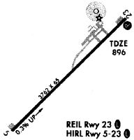
| Runways: | 05/23 |
| Longest Runway: | 05/23 is 3558 ft (1084 m) long |
| Runways with an Instrument Approach: |
KAMT Airport Runway Details
| Runway 05/23 | 3558 ft x 65 ft (1084 m x 20 m) | |
| Runway Length Source: | NGS as of 12/01/1997 | |
| Surface: | Asphalt - Good condition - No special surface treatment | |
| Runway Edge Lights: | Medium Intensity | |
Runway 05 |
Runway 23 |
|
Elevation: |
882.9 | 896.0 |
Latitude: |
38-50-53.6160N | 38-51-18.4244N |
Longitude: |
083-34-13.5670W | 083-33-41.6841W |
|
Runway True Alignment: |
045 | 225 |
Glide Path Angle: |
0.0 degrees | 3.3 degrees |
Traffic Pattern: |
Left | Left |
Runway Markings Type: |
Nonprecision Instrument | Nonprecision Instrument |
Runway Markings Condition: |
Poor | Poor |
Object at End: |
TREES | BRUSH |
Object Height: |
20 | 10 |
Distance from End: |
201 | 201 |
Object Centerline Offset: |
215 ft. left of centerline | 200 ft. left of centerline |
Visual Glide Slope Indicators: |
4-Light PAPI On Left Side Of Runway | |
REIL: |
Yes | Yes |
Threshold Crossing Height: |
25 |
Services
Airframe Repair: |
Major |
Powerplant Repair: |
Major |
Bottled Oxygen: |
Low Pressure |
Bulk Oxygen: |
None |
Fuel Available: |
100LL, Jet A+ |
Landing Fees: |
No |
Parking: |
Hangars and tiedowns available |
Maps & Diagrams
KAMT Sectional
Flight Planning
at skyvector.com
at skyvector.com