Location
Latitude: |
38-29-20.0691N (38.488908) |
Longitude: |
100-28-54.0178W (-100.481671) |
Elevation: |
2779.0 feet MSL (847 m MSL) |
Magnetic Variation: |
5 E (as of April 2024 from WMM2020 model) |
Time Zone: |
UTC -6.0 (Standard Time) UTC -5.0 (Daylight Savings Time) |
From City: |
01 N.M. NW of Dighton, Kansas |
Found On: |
Wichita Chart |
FAA Region: |
ACE |
Contacts
Manager: |
Publicly owned: |
| MARK CALLENDER BOX 115 DIGHTON, KS 67839 620-397-3691 |
CITY-COUNTY BOX 788 DIGHTON, KS 67839 620-397-5356 |
Operations
Airport Status: |
Operational |
Facility Use: |
Public |
Type: |
Airport |
Activation Date: |
08/1947 |
Control tower: |
No |
Attendance (Months/Days/Hours): |
Months/Days/Hours Unattended |
Boundary ARTCC: |
ZKC (Kansas City) |
Responsible ARTCC: |
ZKC (Kansas City) |
Lighting Schedule: |
SEE RMK |
Segmented Circle Indicator: |
No |
Traffic Pattern Altitude (MSL): |
3779 feet (1152 m) |
NOTAMs Facility: |
ICT |
NOTAM-D Service: |
Yes |
Based Aircraft
| Single Engine: | 5 |
Annual Operations (as of 09/25/2020)
| Total Operations: | 1500 | |
| GA Local: | 1000 | 66.7% |
| GA Itinerant: | 500 | 33.3% |
Communications
| CTAF: | 122.900 |
Fixed Based Operators (FBOs) & Fuel
(Click on a business for detail)
Please help us keep this information up to date. This is a FREE SERVICE just like everything else on Airport Guide! If you see that a business needs to be added, modified, or deleted please fill out our Update Form.
To add, modify, or delete a business click here.
Please help us keep this information up to date. This is a FREE SERVICE just like everything else on Airport Guide! If you see that a business needs to be added, modified, or deleted please fill out our Update Form.
Area Code: 620 |
| Business Name | Frequency | Phone | Fuel Grade |
|---|
Flight Service Stations
| Primary | Alternate | |
| FSS on Field: | N | |
| FSS Name (ID): | Wichita(ICT) | |
| Frequency: | ||
| Toll Free Phone: | 1-800-WX-BRIEF |
Instrument Procedures / Charts
Terminal Procedures are only available for airports in several countries with more being added all the time. If you are looking for a specific country's charts, please send an email to support(at)airportguide.com stating the country name. This will be used to prioritize the implementation.
Navigation Aids (Navaids) near K65
| Dist (NM) | ID | Morse Code | Name | Type | Freq | True Hdg | Mag Hdg |
|---|---|---|---|---|---|---|---|
| 19.1 | TQK | _ _ _ . _ _ . _ | Scott City | NDB | 256 | 268 | 263 |
| 36.1 | GCK | _ _ . _ . _ . _ . _ | Garden City | VORTAC | 113.30 | 198 | 193 |
| 40.5 | OEL | _ _ _ . . _ . . | Oakley | NDB | 380 | 337 | 332 |
| 41.2 | GC | _ _ . _ . _ . | Pieve | NDB | 347 | 196 | 191 |
| 44.4 | DDC | _ . . _ . . _ . _ . | Dodge City | VORTAC | 108.20 | 149 | 144 |
| 47.7 | HLC | . . . . . _ . . _ . _ . | Hill City | VORTAC | 113.70 | 14 | 9 |
| 60.1 | HY | . . . . _ . _ _ | Nette | NDB | 374 | 73 | 68 |
| 60.4 | HYS | . . . . _ . _ _ . . . | Hays | VORTAC | 110.40 | 68 | 63 |
| 66.7 | JDM | . _ _ _ _ . . _ _ | Wheatfield | NDB | 408 | 336 | 331 |
| 67.8 | LQR | . _ . . _ _ . _ . _ . | Larned | NDB | 296 | 104 | 99 |
| 67.9 | ULS | . . _ . _ . . . . . | Ulysses | NDB | 395 | 218 | 213 |
| 71.1 | GL | _ _ . . _ . . | Shugr | NDB | 414 | 313 | 308 |
| 74.6 | HIL | . . . . . . . _ . . | Hilyn | NDB | 338 | 95 | 90 |
| 77.8 | GB | _ _ . _ . . . | Babsy | NDB | 419 | 100 | 96 |
| 78.1 | GLD | _ _ . . _ . . _ . . | Goodland | VORTAC | 115.10 | 314 | 309 |
| 78.3 | JHN | . _ _ _ . . . . _ . | Bear Creek | NDB | 341 | 229 | 224 |
| 80.5 | OIN | _ _ _ . . _ . | Oberlin | NDB | 341 | 358 | 353 |
| 86.5 | NRN | _ . . _ . _ . | Norton | NDB | 230 | 18 | 13 |
| 89.7 | LBL | . _ . . _ . . . . _ . . | Liberal | TACAN | 112.30 | 195 | 190 |
| 90.1 | HQG | . . . . _ _ . _ _ _ . | Hugoton | NDB | 365 | 208 | 203 |
Nearby Airports with Fuel
Notices to Airmen (NOTAMS)
Remarks
| A110-1 | PUBLIC PHONE AVBL - 620-397-8651. |
| A110-2 | FOR CD CTC KANSAS CITY ARTCC AT 913-254-8508. |
| A42-24 | RWY 24, 13, 31-NO RWY END MARKINGS. |
| A57-06 | CONTROLLING OBSTN EXCEEDS A 45 DEG SLP. |
| A58-17 | +3 FT FENCE POST 50 FT FROM AER 17. |
| A58-35 | +23 FT RR 65 FT FROM AER CL. |
| A81-APT | ACTVT LIRL 17/35 - CTAF. |
| E111 | EXISTED PRIOR TO 1959. |
Runways
Runway Summary
| Runways: | 06/24 13/31 17/35 H1 |
| Longest Runway: | 17/35 is 2400 ft (732 m) long |
| Runways with an Instrument Approach: |
K65 Airport Runway Details
| Runway 06/24 | 2000 ft x 110 ft (610 m x 34 m) | |
| Surface: | Turf - Fair condition - No special surface treatment | |
Runway 06 |
Runway 24 |
|
Elevation: |
2779.0 | 2774.0 |
Latitude: |
38-29-14.6000N | 38-29-19.9100N |
Longitude: |
100-28-59.4300W | 100-28-35.1700W |
Glide Path Angle: |
0.0 degrees | 0.0 degrees |
Traffic Pattern: |
Left | Left |
Object at End: |
ROAD | |
Object Height: |
15 | |
Distance from End: |
18 | |
Object Centerline Offset: |
0 ft. left and right of centerline |
| Runway 13/31 | 2000 ft x 110 ft (610 m x 34 m) | |
| Runway Length Source: | FAA OE/AAA as of 03/15/2016 | |
| Surface: | Turf - Fair condition - No special surface treatment | |
Runway 13 |
Runway 31 |
|
Elevation: |
2770.0 | 2771.0 |
Latitude: |
38-29-26.5400N | 38-29-11.5800N |
Longitude: |
100-29-00.3200W | 100-28-43.8300W |
Glide Path Angle: |
0.0 degrees | 0.0 degrees |
Traffic Pattern: |
Left | Left |
Runway Markings Type: |
None | |
Object at End: |
RR | |
Object Height: |
23 | |
Distance from End: |
80 | |
Object Centerline Offset: |
0 ft. left and right of centerline | |
REIL: |
No | |
Touchdown Lights: |
No | |
Centerline Lights: |
No |
| Runway 17/35 | 2400 ft x 40 ft (732 m x 12 m) | |
| Runway Length Source: | FAA OE/AAA as of 03/15/2016 | |
| Surface: | Turf - Fair condition - No special surface treatment | |
| Runway Edge Lights: | Low Intensity | |
Runway 17 |
Runway 35 |
|
Latitude: |
38-29-35.1200N | 38-29-11.3900N |
Longitude: |
100-29-01.5800W | 100-29-00.8900W |
Glide Path Angle: |
0.0 degrees | 0.0 degrees |
Traffic Pattern: |
Left | Left |
Runway Markings Type: |
Basic | Basic |
Runway Markings Condition: |
Fair | Fair |
Object at End: |
PLINE | |
Object Height: |
65 | |
Distance from End: |
1300 | |
Object Centerline Offset: |
0 ft. left and right of centerline |
| Helipad H1 | 30 ft x 30 ft (9 m x 9 m) | |
| Runway Length Source: | FAA OE/AAA as of 03/15/2016 | |
| Surface: | Turf - Fair condition - No special surface treatment | |
Helipad H1 |
||
Elevation: |
2777.0 | |
Latitude: |
38-29-25.1100N | |
Longitude: |
100-28-55.4900W | |
Glide Path Angle: |
0.0 degrees | 0.0 degrees |
Object Centerline Offset: |
0 ft. left and right of centerline |
Services
Fuel Available: |
100LL |
Landing Fees: |
No |
Parking: |
Tiedowns available |
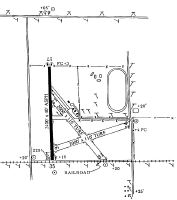
Maps & Diagrams
K65 Sectional
Flight Planning
at skyvector.com
at skyvector.com