Location
Latitude: |
38-50-10.0700N (38.836131) |
Longitude: |
095-10-55.3300W (-95.182036) |
Elevation: |
890.0 feet MSL (271 m MSL) |
Magnetic Variation: |
1.6 E (as of April 2024 from WMM2020 model) |
Time Zone: |
UTC -6.0 (Standard Time) UTC -5.0 (Daylight Savings Time) |
From City: |
03 N.M. N of Baldwin City, Kansas |
Found On: |
Kansas City Chart |
FAA Region: |
ACE |
Contacts
Manager: |
Privately owned: |
| DAVID MCFARLANE 696 E. 1700 RD BALDWIN CITY, KS 66006 785-594-2741 |
K64 LLC 696 E. 1700 RD. BALDWIN CITY, KS 66006 785-594-2741 |
Operations
Airport Status: |
Operational |
Facility Use: |
Public |
Type: |
Airport |
Activation Date: |
10/1969 |
Control tower: |
No |
Attendance (Months/Days/Hours): |
Months/Days/Hours ALL/MON-THURS/0730-1730 |
Boundary ARTCC: |
ZKC (Kansas City) |
Responsible ARTCC: |
ZKC (Kansas City) |
Lighting Schedule: |
SEE RMK |
Segmented Circle Indicator: |
No |
Traffic Pattern Altitude (MSL): |
1890 feet (576 m) |
NOTAMs Facility: |
ICT |
NOTAM-D Service: |
Yes |
Based Aircraft
| Single Engine: | 22 |
Annual Operations (as of 08/31/2018)
| Total Operations: | 5500 | |
| GA Local: | 5000 | 90.9% |
| GA Itinerant: | 500 | 9.1% |
Communications
| CTAF: | 122.900 |
Fixed Based Operators (FBOs) & Fuel
(Click on a business for detail)
Please help us keep this information up to date. This is a FREE SERVICE just like everything else on Airport Guide! If you see that a business needs to be added, modified, or deleted please fill out our Update Form.
To add, modify, or delete a business click here.
Please help us keep this information up to date. This is a FREE SERVICE just like everything else on Airport Guide! If you see that a business needs to be added, modified, or deleted please fill out our Update Form.
Area Code: 785 |
| Business Name | Frequency | Phone | Fuel Grade |
|---|---|---|---|
| McFarlane Aviation, Inc.
Update FBO info |
594-2741 | 100LL |
Flight Service Stations
| Primary | Alternate | |
| FSS on Field: | N | |
| FSS Name (ID): | Wichita(ICT) | |
| Frequency: | ||
| Toll Free Phone: | 1-800-WX-BRIEF |
Instrument Procedures / Charts
Terminal Procedures are only available for airports in several countries with more being added all the time. If you are looking for a specific country's charts, please send an email to support(at)airportguide.com stating the country name. This will be used to prioritize the implementation.
Navigation Aids (Navaids) near K64
| Dist (NM) | ID | Morse Code | Name | Type | Freq | True Hdg | Mag Hdg |
|---|---|---|---|---|---|---|---|
| 4.8 | JZ | . _ _ _ _ _ . . | Newbn | NDB | 338 | 15 | 13 |
| 18.9 | FO | . . _ . _ _ _ | Riply | NDB | 326 | 279 | 277 |
| 20.8 | OJC | _ _ _ . _ _ _ _ . _ . | Johnson County | VOR-DME | 113.00 | 89 | 88 |
| 21.4 | PK | . _ _ . _ . _ | Herbb | NDB | 420 | 103 | 102 |
| 23.4 | FOE | . . _ . _ _ _ . | Forbes | TACAN | 111.60 | 286 | 284 |
| 23.7 | FOE | . . _ . _ _ _ . | Forbes | VOT | 111.00 | 287 | 285 |
| 24.9 | TOP | _ _ _ _ . _ _ . | Topeka | VORTAC | 117.80 | 316 | 314 |
| 28.0 | GQ | _ _ . _ _ . _ | Norge | NDB | 517 | 61 | 60 |
| 29.1 | TO | _ _ _ _ | Biloy | NDB | 521 | 306 | 304 |
| 30.6 | DO | _ . . _ _ _ | Dotte | NDB | 359 | 40 | 39 |
| 32.2 | RIS | . _ . . . . . . | Riverside | VOR-DME | 111.40 | 57 | 56 |
| 32.2 | MKC | _ _ _ . _ _ . _ . | Kansas City Downtown | VOT | 108.60 | 57 | 56 |
| 34.0 | MCI | _ _ _ . _ . . . | Kansas City | VORTAC | 113.25 | 37 | 36 |
| 40.9 | UKL | . . _ _ . _ . _ . . | Boyd | NDB | 245 | 218 | 216 |
| 47.0 | BUM | _ . . . . . _ _ _ | Butler | VORTAC | 115.90 | 135 | 134 |
| 51.5 | ANX | . _ _ . _ . . _ | Napoleon | VORTAC | 114.00 | 72 | 71 |
| 52.0 | ST | . . . _ | Tario | NDB | 260 | 14 | 13 |
| 55.5 | EMP | . _ _ . _ _ . | Emporia | VORTAC | 112.80 | 234 | 232 |
| 61.9 | RBA | . _ . _ . . . . _ | Robinson | DME | 108.2 | 349 | 347 |
| 63.6 | MSB | _ _ . . . _ . . . | Monarch | NDB | 410 | 189 | 187 |
Nearby Airports with Fuel
Notices to Airmen (NOTAMS)
Remarks
| A110-1 | TALL TREES L SIDE AER 16. |
| A110-4 | PATTERN ALTITUDE: FIXED WING AIRCRAFT: 1690 MSL. |
| A110-5 | FOR CD CTC KANSAS CITY ARTCC AT 913-254-8508. |
| A16 | EXT 222. ALT NR: 785-248-3833. |
| A40-16/34 | NSTD LIRL. |
| A70-FUEL-10 | 0LL FUEL ONLY AVLB OP HRS OR W/PRIOR ARRANGEMENT |
| A81-APT | DUSK-DAWN. ACTVT LIRL RY 16/34 - CTAF 3 CLICKS |
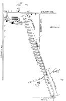
Runways
Runway Summary
| Runways: | 16/34 |
| Longest Runway: | 16/34 is 3030 ft (924 m) long |
| Runways with an Instrument Approach: |
K64 Airport Runway Details
| Runway 16/34 | 3030 ft x 80 ft (924 m x 24 m) | |
| Runway Length Source: | STATE as of 12/23/2002 | |
| Surface: | Turf - Good condition - No special surface treatment | |
| Runway Edge Lights: | Non-standard lighting system Intensity | |
Runway 16 |
Runway 34 |
|
Glide Path Angle: |
0.0 degrees | 0.0 degrees |
Traffic Pattern: |
Left | Left |
Object at End: |
TREE | TREE |
Object Height: |
35 | 31 |
Distance from End: |
427 | 608 |
Object Centerline Offset: |
81 ft. left of centerline | 176 ft. left of centerline |
Services
Airframe Repair: |
Minor |
Powerplant Repair: |
Minor |
Bottled Oxygen: |
None |
Bulk Oxygen: |
None |
Fuel Available: |
100LL |
Landing Fees: |
No |
Parking: |
Tiedowns available |
Maps & Diagrams
K64 Sectional
Flight Planning
at skyvector.com
at skyvector.com