Location
Latitude: |
37-09-28.5347N (37.157926) |
Longitude: |
095-46-44.2209W (-95.77895) |
Elevation: |
824.7 feet MSL (251 m MSL) |
Magnetic Variation: |
2 E (as of April 2024 from WMM2020 model) |
Time Zone: |
UTC -6.0 (Standard Time) UTC -5.0 (Daylight Savings Time) |
From City: |
05 N.M. SW of Independence, Kansas |
Found On: |
Kansas City Chart |
FAA Region: |
ACE |
Contacts
Manager: |
Publicly owned: |
| AARON SHRADER 498 FREEDOM DRIVE INDEPENDENCE, KS 67301 620-332-2531 |
CITY OF INDEPENDENCE 120 N. 6TH INDEPENDENCE, KS 67301 620-332-2500 |
Operations
Airport Status: |
Operational |
Facility Use: |
Public |
Type: |
Airport |
Activation Date: |
02/1944 |
Control tower: |
No |
Attendance (Months/Days/Hours): |
Months/Days/Hours ALL/MON-FRI/0700-1800 |
Boundary ARTCC: |
ZKC (Kansas City) |
Responsible ARTCC: |
ZKC (Kansas City) |
Lighting Schedule: |
SEE RMK |
Segmented Circle Indicator: |
Yes |
Traffic Pattern Altitude (MSL): |
1825 feet (556 m) |
NOTAMs Facility: |
ICT |
NOTAM-D Service: |
Yes |
International Airport of Entry: |
No |
Customs Landing Rights: |
No |
Military Landing Rights: |
Yes |
Civil/Military Joint Use: |
No |
Based Aircraft
| Single Engine: | 12 |
Annual Operations (as of 09/11/2019)
| Total Operations: | 10600 | |
| Air Taxi: | 1400 | 13.2% |
| GA Local: | 5100 | 48.1% |
| GA Itinerant: | 4050 | 38.2% |
| Military Aircraft: | 50 | 0.5% |
Communications
| CTAF: | 123.050 |
| Unicom: | 123.050 |
| AWOS-3PT: | 118.525 (620-331-5980) |
- APCH/DEP CTL SVC PRVDD BY KANSAS CITY ARTCC (ZKC) ON FREQS 128.6/282.325 (EDNA RCAG).
- CLNC DEL PRVDD BY KANSAS CITY ARTCC ON FREQ 121.65.
Fixed Based Operators (FBOs) & Fuel
(Click on a business for detail)
Please help us keep this information up to date. This is a FREE SERVICE just like everything else on Airport Guide! If you see that a business needs to be added, modified, or deleted please fill out our Update Form.
To add, modify, or delete a business click here.
Please help us keep this information up to date. This is a FREE SERVICE just like everything else on Airport Guide! If you see that a business needs to be added, modified, or deleted please fill out our Update Form.
Area Code: 620 |
| Business Name | Frequency | Phone | Fuel Grade |
|---|
Flight Service Stations
| Primary | Alternate | |
| FSS on Field: | N | |
| FSS Name (ID): | Wichita(ICT) | |
| Frequency: | ||
| Toll Free Phone: | 1-800-WX-BRIEF |
Instrument Procedures / Charts
FAA Terminal Procedures valid from 0901Z 03/21/24 to 0901Z 04/18/24.
There are various types of charts available for an airport. They are listed in the Page Type column. Here is a legend for those types:
APD - Airport Diagram
DP - Departure Procedure Charts
HOT - Hot Spots
IAP - Instrument Approach Procedure Charts
MIN - Minimums
STAR - Standard Terminal Arrival Charts
| Page Type | Page Name | Volume | Action Since Last Cycle |
|---|---|---|---|
| APD | AIRPORT DIAGRAM | NC-2 | |
| IAP | ILS OR LOC RWY 35 | NC-2 | |
| IAP | RNAV (GPS) RWY 17 | NC-2 | |
| IAP | RNAV (GPS) RWY 35 | NC-2 | |
| IAP | VOR-A | NC-2 | |
| MIN | ALTERNATE MINIMUMS | NC-2 | |
| MIN | TAKEOFF MINIMUMS | NC-2 |
Terminal Procedures are only available for airports in several countries with more being added all the time. If you are looking for a specific country's charts, please send an email to support(at)airportguide.com stating the country name. This will be used to prioritize the implementation.
Navigation Aids (Navaids) near IDP
| Dist (NM) | ID | Morse Code | Name | Type | Freq | True Hdg | Mag Hdg |
|---|---|---|---|---|---|---|---|
| 10.7 | CFV | _ . _ . . . _ . . . . _ | Coffeyville | NDB | 212 | 111 | 109 |
| 22.2 | BV | _ . . . . . . _ | Dewie | NDB | 201 | 210 | 208 |
| 22.6 | BVO | _ . . . . . . _ _ _ _ | Bartlesville | VOR-DME | 117.90 | 210 | 208 |
| 27.5 | OSW | _ _ _ . . . . _ _ | Oswego | DME | 117.6 | 89 | 87 |
| 29.5 | CNU | _ . _ . _ . . . _ | Chanute | VOR-DME | 109.20 | 17 | 15 |
| 41.8 | MSB | _ _ . . . _ . . . | Monarch | NDB | 410 | 24 | 22 |
| 53.0 | PTS | . _ _ . _ . . . | Pittsburg | NDB | 365 | 70 | 68 |
| 57.7 | TUL | _ . . _ . _ . . | Tulsa Intl | VOT | 109.00 | 185 | 183 |
| 57.7 | TUL | _ . . _ . _ . . | Tulsa | VORTAC | 114.40 | 180 | 178 |
| 58.4 | JL | . _ _ _ . _ . . | Lunns | NDB | 344 | 86 | 84 |
| 60.3 | SO | . . . _ _ _ | Sawcy | NDB | 353 | 266 | 264 |
| 61.6 | FSK | . . _ . . . . _ . _ | Fort Scott | NDB | 379 | 51 | 49 |
| 61.8 | OWP | _ _ _ . _ _ . _ _ . | William Pogue | NDB | 362 | 197 | 195 |
| 63.9 | TU | _ . . _ | Oillr | NDB | 338 | 184 | 182 |
| 66.4 | PN | . _ _ . _ . | Ponca | NDB | 515 | 252 | 250 |
| 67.1 | EOS | . _ _ _ . . . | Neosho | DME | 117.3 | 105 | 103 |
| 68.6 | UKL | . . _ _ . _ . _ . . | Boyd | NDB | 245 | 2 | 0 |
| 70.1 | EMP | . _ _ . _ _ . | Emporia | VORTAC | 112.80 | 346 | 344 |
| 70.7 | PER | . _ _ . . . _ . | Pioneer | VORTAC | 113.20 | 249 | 247 |
| 72.9 | LLU | . _ . . . _ . . . . _ | Spring River | NDB | 356 | 73 | 72 |
Nearby Airports with Fuel
Notices to Airmen (NOTAMS)
Remarks
| A110-10 | RY 35 IS DESIGNATED AS CALM WIND RY. |
| A110-11 | FOR CD CTC KANSAS CITY ARTCC AT 913-254-8508. |
| A110-2 | MANUFACTURED ACFT TESTING ON & INVOF ARPT |
| A110-3 | CROP DUSTING ACFT & AGRICULTURAL EQUIP ON & INVOF ARPT. |
| A110-4 | MIGRATORY BIRDS & WATERFOWL ON & INVOF ARPT. |
| A110-5 | WILDLIFE ON & INVOF RYS. |
| A110-6 | NO LINE ON SIGHT RY 04/22. |
| A110-7 | EXTENSIVE FLIGHT TESTING & FLIGHT TRAINING INVOF ARPT. |
| A110-8 | FARM MACHINERY ON & INVOF ARPT. |
| A110-9 | CROP DUSTING ACTIVITY INVOF ARPT. |
| A70-FUEL-10 | 0LL 100LL ONLY SELF SVC AVBL 24 HRS. |
| A81-APT | ACTVT MALSR RWY 35; PAPI RWY 04 & 22; MIRL RWY 04 & 22: HIRL RWY 17 & 35 - CTAF. |
| A83 | WIND SOCK FADED |
| E111 | PRVDD A CLEAR APCH TO EACH RY MAINTAINED FOR A MINIMUM 20:1 GLIDE SLOPE & A CLEAR TRANSITIONAL SFC IS MAINTAINED FOR A 7:1 SLOPE. |
Runways
Runway Summary
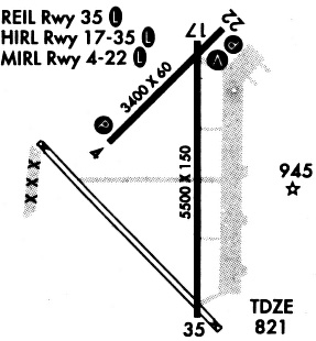
| Runways: | 04/22 17/35 |
| Longest Runway: | 17/35 is 5501 ft (1677 m) long |
| Runways with an Instrument Approach: | 35 |
IDP Airport Runway Details
| Runway 04/22 | 3402 ft x 60 ft (1037 m x 18 m) | |
| Runway Length Source: | 3RD PARTY SURVEY as of 10/22/2009 | |
| Surface: | Asphalt - Fair condition - No special surface treatment | |
| Runway Pavement Class: | 12 /F/D/X/T | |
| Runway Edge Lights: | Medium Intensity | |
Runway Weight Bearing Capacity (in thousands of pounds) |
||
| Single Wheel Landing Gear: | 32.0 | |
| Dual Wheel Landing Gear: | 43.0 | |
Runway 04 |
Runway 22 |
|
Elevation: |
820.2 | 820.1 |
Latitude: |
37-09-21.0720N | 37-09-44.7360N |
Longitude: |
095-47-12.8210W | 095-46-42.9560W |
|
Runway True Alignment: |
045 | 225 |
Glide Path Angle: |
0.0 degrees | 0.0 degrees |
Traffic Pattern: |
Left | Left |
Runway Markings Type: |
Nonprecision Instrument | Nonprecision Instrument |
Runway Markings Condition: |
Good | Good |
Visual Glide Slope Indicators: |
4-Light PAPI On Left Side Of Runway | 4-Light PAPI On Left Side Of Runway |
| Runway 17/35 | 5501 ft x 100 ft (1677 m x 30 m) | |
| Runway Length Source: | 3RD PARTY SURVEY as of 10/22/2009 | |
| Surface: | Asphalt - Fair condition - No special surface treatment | |
| Runway Pavement Class: | 15 /R/D/X/T | |
| Runway Edge Lights: | High Intensity | |
Runway Weight Bearing Capacity (in thousands of pounds) |
||
| Single Wheel Landing Gear: | 44.0 | |
| Dual Wheel Landing Gear: | 56.0 | |
Runway 17 |
Runway 35 |
|
Elevation: |
821.1 | 819.4 |
Latitude: |
37-09-53.0274N | 37-08-58.6376N |
Longitude: |
095-46-35.5984W | 095-46-35.9384W |
|
Runway True Alignment: |
180 | 000 |
ILS Type: |
ILS/DME | |
Glide Path Angle: |
0.0 degrees | 3.0 degrees |
Traffic Pattern: |
Left | Left |
Runway Markings Type: |
Nonprecision Instrument | Precision Instrument |
Runway Markings Condition: |
Good | Good |
Object at End: |
TREES | |
Object Height: |
50 | |
Distance from End: |
2351 | |
Visual Glide Slope Indicators: |
4-Light PAPI On Left Side Of Runway | |
Approach Light System: |
1,400 Foot Medium Intensity Approach Lighting System With Runway Alignment Indicator Lights | |
REIL: |
Yes | No |
Threshold Crossing Height: |
42 |
Services
Airframe Repair: |
None |
Powerplant Repair: |
None |
Bottled Oxygen: |
None |
Bulk Oxygen: |
None |
Fuel Available: |
100LL |
Landing Fees: |
No |
Parking: |
Tiedowns available |
Maps & Diagrams
IDP Sectional
Flight Planning
at skyvector.com
at skyvector.com