Location
Latitude: |
35-30-39.8100N (35.511058) |
Longitude: |
108-47-21.5140W (-108.789309) |
Elevation: |
6472.3 feet MSL (1973 m MSL) |
Magnetic Variation: |
8.9 E (as of April 2024 from WMM2020 model) |
Time Zone: |
UTC -7.0 (Standard Time) UTC -6.0 (Daylight Savings Time) |
From City: |
03 N.M. SW of Gallup, New Mexico |
Found On: |
Albuquerque Chart |
FAA Region: |
ASW |
Contacts
Manager: |
Publicly owned: |
| ROBERT HAMBLEN 110 WEST AZTEC GALLUP, NM 87301 505-863-1290 |
CITY OF GALLUP BOX 1270 GALLUP, NM 87305 505-863-1254 |
Operations
Airport Status: |
Operational |
Facility Use: |
Public |
Type: |
Airport |
Control tower: |
No |
Attendance (Months/Days/Hours): |
Months/Days/Hours OCT-MAR/MON-FRI/0730-1730 |
Boundary ARTCC: |
ZAB (Albuquerque) |
Responsible ARTCC: |
ZAB (Albuquerque) |
Lighting Schedule: |
SEE RMK |
Segmented Circle Indicator: |
Yes |
Traffic Pattern Altitude (MSL): |
7472 feet (2277 m) |
NOTAMs Facility: |
GUP |
NOTAM-D Service: |
Yes |
International Airport of Entry: |
No |
Customs Landing Rights: |
No |
Military Landing Rights: |
Yes |
Civil/Military Joint Use: |
No |
Based Aircraft
| Single Engine: | 14 |
| Multi Engine: | 2 |
| GA Helicopters: | 2 |
Annual Operations (as of 04/07/2021)
| Total Operations: | 6200 | |
| Air Taxi: | 3000 | 48.4% |
| GA Local: | 200 | 3.2% |
| GA Itinerant: | 2000 | 32.3% |
| Military Aircraft: | 1000 | 16.1% |
Communications
| CTAF: | 122.950 |
| Unicom: | 122.950 |
| ASOS: | 118.375 (505-726-8232) |
- COMMUNICATIONS PRVDD BY ALBUQUERQUE RADIO ON FREQ 122.1R (GALLUP RCO).
- APCH/DEP SVC PRVDD BY ALBUQUERQUE ARTCC (ZAB) ON 124.325/288.25 (WEST MESA RCAG).
Fixed Based Operators (FBOs) & Fuel
(Click on a business for detail)
Please help us keep this information up to date. This is a FREE SERVICE just like everything else on Airport Guide! If you see that a business needs to be added, modified, or deleted please fill out our Update Form.
To add, modify, or delete a business click here.
Please help us keep this information up to date. This is a FREE SERVICE just like everything else on Airport Guide! If you see that a business needs to be added, modified, or deleted please fill out our Update Form.
Area Code: 505 |
| Business Name | Frequency | Phone | Fuel Grade |
|---|---|---|---|
| Gallup Flying Service
Update FBO info |
Unicom 122.95 | 863-6606, -4998 | 100LL, Jet A |
Flight Service Stations
| Primary | Alternate | |
| FSS on Field: | N | |
| FSS Name (ID): | Albuquerque(ABQ) | |
| Frequency: | ||
| Toll Free Phone: | 1-800-WX-BRIEF |
Instrument Procedures / Charts
FAA Terminal Procedures valid from 0901Z 03/21/24 to 0901Z 04/18/24.
There are various types of charts available for an airport. They are listed in the Page Type column. Here is a legend for those types:
APD - Airport Diagram
DP - Departure Procedure Charts
HOT - Hot Spots
IAP - Instrument Approach Procedure Charts
MIN - Minimums
STAR - Standard Terminal Arrival Charts
| Page Type | Page Name | Volume | Action Since Last Cycle |
|---|---|---|---|
| IAP | LOC RWY 06 | SW-1 | |
| IAP | RNAV (GPS) RWY 06 | SW-1 | |
| IAP | RNAV (GPS) RWY 24 | SW-1 | |
| IAP | VOR RWY 06 | SW-1 | |
| MIN | ALTERNATE MINIMUMS | SW-1 | |
| MIN | TAKEOFF MINIMUMS | SW-1 |
Terminal Procedures are only available for airports in several countries with more being added all the time. If you are looking for a specific country's charts, please send an email to support(at)airportguide.com stating the country name. This will be used to prioritize the implementation.
Navigation Aids (Navaids) near GUP
| Dist (NM) | ID | Morse Code | Name | Type | Freq | True Hdg | Mag Hdg |
|---|---|---|---|---|---|---|---|
| 4.6 | GUP | _ _ . . . _ . _ _ . | Gallup | VORTAC | 115.10 | 242 | 233 |
| 16.4 | AWR | . _ . _ _ . _ . | Window Rock | NDB | 254 | 304 | 295 |
| 37.3 | ZUN | _ _ . . . . _ _ . | Zuni | VORTAC | 113.40 | 208 | 199 |
| 67.5 | SJN | . . . . _ _ _ _ . | St Johns | VORTAC | 112.30 | 195 | 186 |
| 81.4 | RSK | . _ . . . . _ . _ | Rattlesnake | VORTAC | 115.30 | 24 | 15 |
| 95.7 | SOW | . . . _ _ _ . _ _ | Show Low | NDB | 206 | 219 | 210 |
Nearby Airports with Fuel
| Dist (NM) | Name (Airport IDs) | True Hdg | Mag Hdg | Fuel Grade |
|---|---|---|---|---|
| 16.0 | Window Rock Airport (KRQE RQE) |
302 | 293 | 100LL |
| 48.1 | Grants-Milan Municipal Airport (GNT KGNT GNT) |
115 | 107 | 100LL, Jet A-1+ |
| 66.2 | St Johns Industrial Air Park Airport (SJN KSJN SJN) |
206 | 197 | 100LL, Jet A+ |
| 74.5 | Holbrook Municipal Airport (P14) |
243 | 234 | 100LL |
| 78.6 | Four Corners Regional Airport (FMN KFMN FMN) |
20 | 11 | 100LL, Jet A, Jet A-1+ |
| 91.0 | Taylor Airport (TYZ KTYL TYL) |
226 | 217 | 100LL |
| 95.8 | Show Low Regional Airport (SOW KSOW SOW) |
219 | 210 | 100LL, Jet A |
| 99.1 | Winslow-Lindbergh Regional Airport (INW KINW INW) |
253 | 243 | 100LL, Jet A |
Notices to Airmen (NOTAMS)
Remarks
| A110-1 | PREFERRED CALM WIND RUNWAY 24. |
| A110-2 | FOR CD IF UNA TO CTC ON FSS FREQ, CTC ALBUQUERQUE ARTCC AT 505-856-4561. |
| A16 | EMERGENCY PHONE: AARON LESLIE 505-870-2788. |
| A70-FUEL-A1 | + 24 HR. SELF SERVE 100 LL & JET A1+ WITH MAJOR CREDIT CARD. AFTER HOUR SERVICE AVAILABLE WITH CALL OUT FEE. |
| A81-APT | ACTVT MIRL RY 06/24 & REIL RY 24 - CTAF. |
Runways
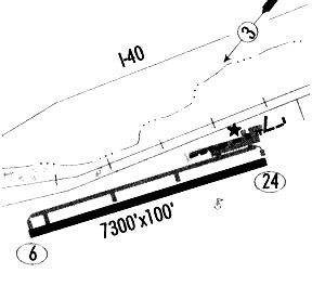
Runway Summary
| Runways: | 06/24 |
| Longest Runway: | 06/24 is 7315 ft (2230 m) long |
| Runways with an Instrument Approach: | 06 |
GUP Airport Runway Details
| Runway 06/24 | 7315 ft x 100 ft (2230 m x 30 m) | |
| Runway Length Source: | 3RD PARTY SURVEY as of 03/28/2007 | |
| Surface: | Asphalt - Good condition - No special surface treatment | |
| Runway Pavement Class: | 39 /F/C/X/T | |
| Runway Edge Lights: | Medium Intensity | |
Runway Weight Bearing Capacity (in thousands of pounds) |
||
| Single Wheel Landing Gear: | 45.0 | |
| Dual Wheel Landing Gear: | 55.0 | |
Runway 06 |
Runway 24 |
|
Elevation: |
6464.4 | 6472.0 |
Latitude: |
35-30-29.7742N | 35-30-49.8480N |
Longitude: |
108-48-03.9885W | 108-46-39.0162W |
|
Runway True Alignment: |
074 | 254 |
ILS Type: |
LOC/DME | |
Glide Path Angle: |
3.0 degrees | 3.0 degrees |
Traffic Pattern: |
Left | Left |
Runway Markings Type: |
Nonprecision Instrument | Nonprecision Instrument |
Runway Markings Condition: |
Good | Good |
Object at End: |
TREE | TREE |
Object Height: |
34 | 35 |
Distance from End: |
1325 | 1375 |
Object Centerline Offset: |
50 ft. left of centerline | 200 ft. left of centerline |
Visual Glide Slope Indicators: |
2-Light PAPI On Left Side Of Runway | 2-Light PAPI On Left Side Of Runway |
REIL: |
Yes | |
Threshold Crossing Height: |
46 | 48 |
Services
Airframe Repair: |
None |
Powerplant Repair: |
None |
Bulk Oxygen: |
None |
Fuel Available: |
100LL, Jet A |
Landing Fees: |
No |
Parking: |
Hangars and tiedowns available |
Maps & Diagrams
GUP Sectional
Flight Planning
at skyvector.com
at skyvector.com