Location
Latitude: |
58-25-31.0000N (58.425278) |
Longitude: |
135-42-26.7000W (-135.707417) |
Elevation: |
36.3 feet MSL (11 m MSL) |
Magnetic Variation: |
18.1 E (as of April 2024 from WMM2020 model) |
Time Zone: |
UTC -9.0 (Standard Time) UTC -8.0 (Daylight Savings Time) |
From City: |
00 N.M. NE of Gustavus, Alaska |
Found On: |
Juneau Chart |
FAA Region: |
AAL |
Contacts
Manager: |
Publicly owned: |
| JEFF JARVIS PO BOX 239 GUSTAVUS, AK 99826 907-697-2251 |
ALASKA DOT&PF SOUTHCOAST REGION 6860 GLACIER HWY JUNEAU, AK 99801-7999 907-465-1786 |
Operations
Airport Status: |
Operational |
Facility Use: |
Public |
Type: |
Airport |
Activation Date: |
01/1949 |
Control tower: |
No |
Attendance (Months/Days/Hours): |
Months/Days/Hours 1 SEP-15 MAY/ALL/0600-1430 |
Boundary ARTCC: |
ZAN (Anchorage) |
Responsible ARTCC: |
ZAN (Anchorage) |
Lighting Schedule: |
SEE RMK |
Segmented Circle Indicator: |
Yes |
Traffic Pattern Altitude (MSL): |
1036 feet (316 m) |
NOTAMs Facility: |
GST |
NOTAM-D Service: |
Yes |
International Airport of Entry: |
No |
Customs Landing Rights: |
No |
Military Landing Rights: |
Yes |
Civil/Military Joint Use: |
No |
Aircraft Rescue and Firefighting: |
Class I ARFF Index: A Air Carrier Service: Scheduled Certification Date: 03/2005 |
Based Aircraft
| Single Engine: | 11 |
| Multi Engine: | 1 |
| GA Helicopters: | 1 |
Annual Operations (as of 04/30/2019)
| Total Operations: | 5750 | |
| Commercial: | 200 | 3.5% |
| Air Taxi: | 3300 | 57.4% |
| GA Local: | 200 | 3.5% |
| GA Itinerant: | 2000 | 34.8% |
| Military Aircraft: | 50 | 0.9% |
Communications
| CTAF: | 122.500 |
| AWOS-3P: | 125.9 (907-697-2447) |
- APCH/DEP SVC PRVDD BY ANCHORAGE ARTCC ON FREQS 133.2/360.65 (GUSTAVUS RCAG).
- COMMUNICATIONS PRVDD BY JUNEAU FSS ON FREQ 122.65 (GUSTAVUS RCO).
Fixed Based Operators (FBOs) & Fuel
(Click on a business for detail)
Please help us keep this information up to date. This is a FREE SERVICE just like everything else on Airport Guide! If you see that a business needs to be added, modified, or deleted please fill out our Update Form.
To add, modify, or delete a business click here.
Please help us keep this information up to date. This is a FREE SERVICE just like everything else on Airport Guide! If you see that a business needs to be added, modified, or deleted please fill out our Update Form.
Area Code: 907 |
| Business Name | Frequency | Phone | Fuel Grade |
|---|---|---|---|
| Aero Services, Inc.
Website Update FBO info |
Unicom 122.95 | 697-2217, 697-2517, 888-286-3835 | 100LL, Jet A |
| Flight Engineering, Inc.
Update FBO info |
Unicom 122.85 | 697-2454 | |
| Gustavus Dray, Inc.
Update FBO info |
697-2481 | 100LL, Jet A | |
| K & W Company
Update FBO info |
697-2217 | 100LL |
Flight Service Stations
| Primary | Alternate | |
| FSS on Field: | N | |
| FSS Name (ID): | Juneau(JNU) | |
| Frequency: | ||
| Toll Free Phone: | 1-866-297-2236 |
Instrument Procedures / Charts
FAA Terminal Procedures valid from 0901Z 03/21/24 to 0901Z 04/18/24.
There are various types of charts available for an airport. They are listed in the Page Type column. Here is a legend for those types:
APD - Airport Diagram
DP - Departure Procedure Charts
HOT - Hot Spots
IAP - Instrument Approach Procedure Charts
MIN - Minimums
STAR - Standard Terminal Arrival Charts
| Page Type | Page Name | Volume | Action Since Last Cycle |
|---|---|---|---|
| IAP | RNAV (GPS) RWY 29 | AK-1 | Changed |
| IAP | VOR/DME RWY 29 | AK-1 | |
| MIN | ALTERNATE MINIMUMS | AK-1 | |
| MIN | TAKEOFF MINIMUMS | AK-1 | |
| ODP | GUSTAVUS TWO (OBSTACLE) | AK-1 | |
| ODP | GUSTAVUS TWO (OBSTACLE)[DELIMITER] CONT.1 | AK-1 | |
| ODP | GUSTAVUS TWO (OBSTACLE)[DELIMITER] CONT.2 | AK-1 | |
| ODP | GUSTAVUS TWO (OBSTACLE)[DELIMITER] CONT.3 | AK-1 |
Terminal Procedures are only available for airports in several countries with more being added all the time. If you are looking for a specific country's charts, please send an email to support(at)airportguide.com stating the country name. This will be used to prioritize the implementation.
Navigation Aids (Navaids) near GST
| Dist (NM) | ID | Morse Code | Name | Type | Freq | True Hdg | Mag Hdg |
|---|---|---|---|---|---|---|---|
| 0.2 | GAV | _ _ . . _ . . . _ | Gustavus | NDB | 219 | 169 | 151 |
| 20.0 | JDL | . _ _ _ _ . . . _ . . | Lynns | FAN MARKER | 101 | 83 | |
| 20.5 | SSR | . . . . . . . _ . | Sisters Island | VORTAC | 114.00 | 136 | 118 |
| 20.8 | EEF | . . . . _ . | Elephant | NDB | 391 | 136 | 118 |
| 31.9 | CGL | _ . _ . _ _ . . _ . . | Coghlan Island | NDB | 212 | 96 | 78 |
| 34.0 | JNU | . _ _ _ _ . . . _ | Juneau | VOT | 111.00 | 96 | 78 |
| 48.0 | HNS | . . . . _ . . . . | Haines | NDB | 245 | 10 | 352 |
| 83.4 | IME | . . _ _ . | Mount Edgecumbe | NDB | 414 | 172 | 154 |
| 94.1 | BKA | _ . . . _ . _ . _ | Biorka Island | VORTAC | 113.80 | 176 | 158 |
| 94.4 | SIT | . . . . . _ | Sitka | NDB | 358 | 176 | 158 |
Nearby Airports with Fuel
| Dist (NM) | Name (Airport IDs) | True Hdg | Mag Hdg | Fuel Grade |
|---|---|---|---|---|
| 35.8 | Juneau International Airport (JNU PAJN JNU) |
96 | 78 | 100LL, Jet A-1+ |
| 49.4 | Haines Airport (HNS PAHN HNS) |
6 | 348 | 100LL, Jet A |
| 63.3 | Skagway Airport (SGY PAGY SGY) |
10 | 352 | 100LL |
| 83.4 | Sitka Rocky Gutierrez Airport (SIT PASI SIT) |
172 | 154 | 100, Jet A-1+ |
Notices to Airmen (NOTAMS)
Remarks
| A110-11 | TSNT PRKG E SIDE OF RWY 02/20; ASPH SFC SOFT; ACFT OVR 12500 LBS CTC AMGR 24 HR PRIOR MON-FRI 0600-1430. |
| A110-15 | GUSTAVUS & SISTERS ISLAND WX CAMERA AVBL ON INTERNET AT HTTPS://WEATHERCAMS.FAA.GOV |
| A110-16 | 24 HR PPR FOR CARGO OPS OVR 100000 LB - AMGR. |
| A110-17 | BE ALERT: SEE GENNOT - ENROUTE CTAF FREQS. |
| A110-19 | LTD ARPT MAINT SVC AVBL: 1 SEP-14 MAY 0600-1430; 15 MAY-1 SEP FRI-MON 1000-1830, TUE-THU 0600-1830. AFT HR - AMGR. |
| A110-20 | ARPT SAND LRGR GRADATION THAN FAA RCMDD/SEE AC150/5200-30. |
| A110-21 | COLD TEMPERATURE AIRPORT. ALTITUDE CORRECTION REQUIRED AT OR BELOW -18C. |
| A110-22 | TSNT PRKG AVBL GA RAMP ACES VIA TWY F. |
| A110-3 | PAJA ON RWY, TWY OR PRKG APRON NA. |
| A110-9 | WILDLIFE ON & INVOF RWY. |
| A26 | ARFF SVC AVBL DURG SKED ACR OPS. |
| A26 1 | CLSD TO ACR OPS MORE THAN 30 PAX SEATS EXC PPR IN WRITING - RGNL DIR DOT & PUB FAC SE RGN 6860 GLACIER HIGHWAY JUNEAK AK 99801-7999. |
| A30-02/20 | 9 FT FENCE 554 FT S. NOT AVBL FOR SKED OR UNSKED ACR OPS MORE THAN 30 PAX SEATS. MNTND WINTER MONTHS; RCMD DAYLIGHT OPS ONLY. |
| A70-FUEL-A | CFM AVBL - 907-209-0305. |
| A81-APT | ACTVT REIL RWY 11 & 29; VASI RWY 11 & 29; MIRL RWY 11/29 - CTAF |
Runways
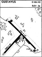
Runway Summary
| Runways: | 02/20 11/29 |
| Longest Runway: | 11/29 is 6720 ft (2048 m) long |
| Runways with an Instrument Approach: |
GST Airport Runway Details
| Runway 02/20 | 3010 ft x 60 ft (917 m x 18 m) | |
| Runway Length Source: | 3RD PARTY SURVEY as of 08/30/2016 | |
| Surface: | Asphalt - Good condition - No special surface treatment | |
| Runway Pavement Class: | 18 /F/B/X/T | |
Runway Weight Bearing Capacity (in thousands of pounds) |
||
| Single Wheel Landing Gear: | 40.0 | |
Runway 02 |
Runway 20 |
|
Elevation: |
30.5 | 32.4 |
Latitude: |
58-25-12.2297N | 58-25-34.6057N |
Longitude: |
135-43-05.4936W | 135-42-28.4044W |
|
Runway True Alignment: |
041 | 221 |
Glide Path Angle: |
0.0 degrees | 0.0 degrees |
Traffic Pattern: |
Left | Left |
Runway Markings Type: |
Nonprecision Instrument | Nonprecision Instrument |
Runway Markings Condition: |
Good | Good |
Object at End: |
TREES | TREES |
Object Height: |
18 | 72 |
Distance from End: |
650 | 1200 |
Object Centerline Offset: |
0 ft. left and right of centerline |
| Runway 11/29 | 6720 ft x 150 ft (2048 m x 46 m) | |
| Runway Length Source: | 3RD PARTY SURVEY as of 08/30/2016 | |
| Surface: | Asphalt - Good condition - Saw-cut or plastic grooved | |
| Runway Pavement Class: | 28 /F/B/X/T | |
| Runway Edge Lights: | Medium Intensity | |
Runway Weight Bearing Capacity (in thousands of pounds) |
||
| Single Wheel Landing Gear: | 60.0 | |
| Dual Wheel Landing Gear: | 100.0 | |
Runway 11 |
Runway 29 |
|
Elevation: |
36.2 | 29.2 |
Latitude: |
58-25-57.7725N | 58-25-10.9400N |
Longitude: |
135-43-02.2051W | 135-41-33.0080W |
|
Runway True Alignment: |
135 | 315 |
Glide Path Angle: |
3.0 degrees | 3.0 degrees |
Traffic Pattern: |
Left | Left |
Runway Markings Type: |
Nonprecision Instrument | Nonprecision Instrument |
Runway Markings Condition: |
Good | Good |
Object Centerline Offset: |
0 ft. left and right of centerline | |
Visual Glide Slope Indicators: |
4-Box VASI On Right Side Of Runway | 4-Box VASI On Left Side Of Runway |
REIL: |
Yes | Yes |
Threshold Crossing Height: |
35 | 39 |
Services
Airframe Repair: |
Major |
Powerplant Repair: |
Major |
Fuel Available: |
100, Jet A-1+ |
Landing Fees: |
No |
Parking: |
Tiedowns available |
Maps & Diagrams
GST Sectional
Flight Planning
at skyvector.com
at skyvector.com