
Location
Latitude: |
23-26-08.0031S (-23.435556) |
Longitude: |
046-28-23.0045W (-46.473057) |
Elevation: |
2459 feet MSL (750 m MSL) |
Magnetic Variation: |
21.9 W (as of April 2024 from WMM2020 model) |
Time Zone: |
UTC -3.0 (Standard Time) UTC -2.0 (Daylight Savings Time) |
Contacts
Manager: |
: |
Operations
Airport Status: |
Operational |
Facility Use: |
Public |
Type: |
Airport |
Traffic Pattern Altitude (MSL): |
3459 feet (1054 m) |
Based Aircraft
Annual Operations (as of )
Communications
| TWR: | 118.4 |
| CLNC DEL: | 121 |
| GND: | 121.7 |
| SAO PAULO APP: | 119.8 |
| ATIS: | 127.75 |
| RWY 27L: | 111.1 |
| SAO PAULO OPS: | 122.5 |
Fixed Based Operators (FBOs) & Fuel
(Click on a business for detail)
Please help us keep this information up to date. This is a FREE SERVICE just like everything else on Airport Guide! If you see that a business needs to be added, modified, or deleted please fill out our Update Form.
To add, modify, or delete a business click here.
Please help us keep this information up to date. This is a FREE SERVICE just like everything else on Airport Guide! If you see that a business needs to be added, modified, or deleted please fill out our Update Form.
| Business Name | Frequency | Phone | Fuel Grade |
|---|
Flight Service Stations
| Primary | Alternate | |
| FSS on Field: | ||
| FSS Name (ID): | ||
| Frequency: | ||
| Toll Free Phone: |
Instrument Procedures / Charts
Terminal Procedures are only available for airports in several countries with more being added all the time. If you are looking for a specific country's charts, please send an email to support(at)airportguide.com stating the country name. This will be used to prioritize the implementation.
Navigation Aids (Navaids) near GRU
| Dist (NM) | ID | Morse Code | Name | Type | Freq | True Hdg | Mag Hdg |
|---|---|---|---|---|---|---|---|
| 5.0 | IB | Bonsucesso | NDB | 240 | 70 | 92 | |
| 5.1 | BCO | Bonsucesso | VOR-DME | 116.00 | 70 | 92 | |
| 5.7 | IG | Tuca | NDB | 410 | 253 | 275 | |
| 10.0 | MAE | Marte | NDB | 260 | 244 | 266 | |
| 14.7 | IS | Mada | NDB | 290 | 243 | 265 | |
| 15.0 | SPO | Sao Paulo | NDB | 250 | 225 | 247 | |
| 15.2 | CGO | Congonhas | VOR-DME | 116.90 | 220 | 242 | |
| 15.6 | PER | Perus | NDB | 220 | 273 | 295 | |
| 15.6 | PP | Metro | NDB | 330 | 216 | 238 | |
| 17.7 | DAD | Diadema | NDB | 200 | 203 | 225 | |
| 25.0 | STN | Santana | VOR-DME | 114.30 | 262 | 284 | |
| 25.9 | TPV | Itapevi | NDB | 270 | 252 | 274 | |
| 27.5 | RDE | Rede | VOR-DME | 116.70 | 186 | 208 | |
| 28.2 | BGC | Braganca | NDB | 385 | 351 | 373 | |
| 29.4 | BGC | Braganca | VOR-DME | 116.20 | 349 | 371 | |
| 31.2 | EMB | Embuguacu | NDB | 525 | 217 | 239 | |
| 32.4 | RR | Vicente | NDB | 360 | 161 | 183 | |
| 34.0 | IW | Jaguari | NDB | 230 | 61 | 83 | |
| 34.8 | SAT | Santos | NDB | 375 | 160 | 182 | |
| 35.3 | IJ | Vila | NDB | 365 | 67 | 89 |
Nearby Airports with Fuel
| Dist (NM) | Name (Airport IDs) | True Hdg | Mag Hdg | Fuel Grade |
|---|
Notices to Airmen (NOTAMS)
Remarks
No remarks for this landing facility
Runways
Runway Summary
| Runways: | 10L/28R 10R/28L |
| Longest Runway: | 10L/28R is 12139 ft (3700 m) long |
| Runways with an Instrument Approach: |
GRU Airport Runway Details
| Runway 10L/28R | 12139 ft x 148 ft (3700 m x 45 m) | |
| Runway Edge Lights: | Yes Intensity | |
Runway 10L |
Runway 28R |
|
Elevation: |
2445 | 2440 |
Latitude: |
-23.434059 | -23.425043 |
Longitude: |
-46.482548 | -46.449203 |
|
Runway True Alignment: |
74 | 254 |
Glide Path Angle: |
0.0 degrees | 0.0 degrees |
REIL: |
Yes | Yes |
Threshold Elevation: |
2445 | 2440 |
| Runway 10R/28L | 9843 ft x 148 ft (3000 m x 45 m) | |
| Runway Edge Lights: | Yes Intensity | |
Runway 10R |
Runway 28L |
|
Elevation: |
2450 | 2445 |
Latitude: |
-23.438801 | -23.4312 |
Longitude: |
-46.487 | -46.4589 |
|
Runway True Alignment: |
74 | 254 |
Glide Path Angle: |
0.0 degrees | 0.0 degrees |
REIL: |
Yes | Yes |
Threshold Elevation: |
2450 | 2445 |
Services
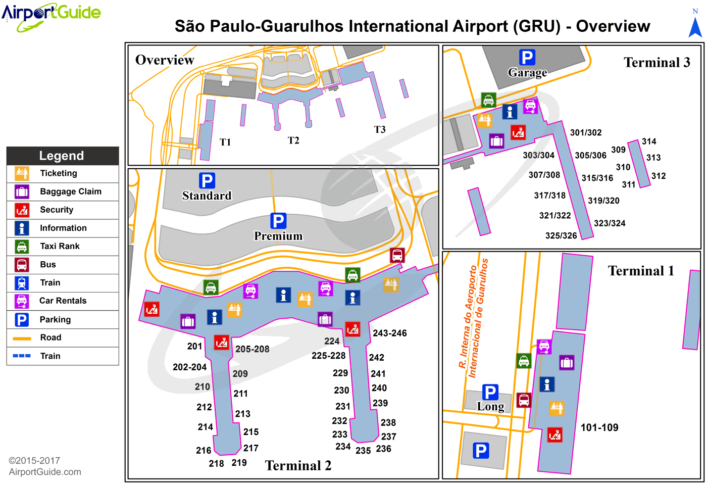
Maps & Diagrams
GRU Sectional
Flight Planning
at skyvector.com
at skyvector.com
