Location
Latitude: |
64-32-50.2800N (64.5473) |
Longitude: |
149-04-26.1300W (-149.073925) |
Elevation: |
367.7 feet MSL (112 m MSL) |
Magnetic Variation: |
15.2 E (as of April 2024 from WMM2020 model) |
Time Zone: |
UTC -9.0 (Standard Time) UTC -8.0 (Daylight Savings Time) |
From City: |
01 N.M. S of Nenana, Alaska |
Found On: |
Fairbanks Chart |
FAA Region: |
AAL |
Contacts
Manager: |
Publicly owned: |
| DAN SMITH NENANA, AK 99760 907-888-9065 |
CITY OF NENANA BOX 70 NENANA, AK 99760 907-832-5441 |
Operations
Airport Status: |
Operational |
Facility Use: |
Public |
Type: |
Airport |
Activation Date: |
04/1949 |
Control tower: |
No |
Attendance (Months/Days/Hours): |
Months/Days/Hours UNATTND |
Boundary ARTCC: |
ZAN (Anchorage) |
Responsible ARTCC: |
ZAN (Anchorage) |
Lighting Schedule: |
SEE RMK |
Segmented Circle Indicator: |
Yes |
Traffic Pattern Altitude (MSL): |
1368 feet (417 m) |
NOTAMs Facility: |
ENN |
NOTAM-D Service: |
Yes |
International Airport of Entry: |
No |
Customs Landing Rights: |
No |
Military Landing Rights: |
Yes |
Civil/Military Joint Use: |
No |
Based Aircraft
| Single Engine: | 19 |
Annual Operations (as of 12/31/2019)
| Total Operations: | 6000 | |
| Air Taxi: | 2500 | 41.7% |
| GA Local: | 1500 | 25.0% |
| GA Itinerant: | 2000 | 33.3% |
Communications
| CTAF: | 122.100 |
| Approach: | FAIRBANKS 125.35 125.35 125.35 125.35 |
| Departure: | FAIRBANKS 125.35 125.35 125.35 125.35 |
| ASOS: | 125.2 (907-832-5689) |
- COMMUNICATIONS PRVDD BY FAIRBANKS FSS ON FREQ 122.50 (NENANA RCO).
Fixed Based Operators (FBOs) & Fuel
(Click on a business for detail)
Please help us keep this information up to date. This is a FREE SERVICE just like everything else on Airport Guide! If you see that a business needs to be added, modified, or deleted please fill out our Update Form.
To add, modify, or delete a business click here.
Please help us keep this information up to date. This is a FREE SERVICE just like everything else on Airport Guide! If you see that a business needs to be added, modified, or deleted please fill out our Update Form.
Area Code: 907 |
| Business Name | Frequency | Phone | Fuel Grade |
|---|---|---|---|
| Nenana Municipal
Update FBO info |
832-5441 |
Flight Service Stations
| Primary | Alternate | |
| FSS on Field: | N | |
| FSS Name (ID): | Fairbanks(FAI) | |
| Frequency: | ||
| Toll Free Phone: | 1-866-248-6516 |
Instrument Procedures / Charts
FAA Terminal Procedures valid from 0901Z 03/21/24 to 0901Z 04/18/24.
There are various types of charts available for an airport. They are listed in the Page Type column. Here is a legend for those types:
APD - Airport Diagram
DP - Departure Procedure Charts
HOT - Hot Spots
IAP - Instrument Approach Procedure Charts
MIN - Minimums
STAR - Standard Terminal Arrival Charts
| Page Type | Page Name | Volume | Action Since Last Cycle |
|---|---|---|---|
| IAP | NDB RWY 04L | AK-1 | |
| IAP | RNAV (GPS) RWY 04L | AK-1 | |
| MIN | ALTERNATE MINIMUMS | AK-1 | |
| MIN | TAKEOFF MINIMUMS | AK-1 |
Terminal Procedures are only available for airports in several countries with more being added all the time. If you are looking for a specific country's charts, please send an email to support(at)airportguide.com stating the country name. This will be used to prioritize the implementation.
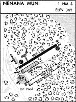
Navigation Aids (Navaids) near ENN
| Dist (NM) | ID | Morse Code | Name | Type | Freq | True Hdg | Mag Hdg |
|---|---|---|---|---|---|---|---|
| 0.1 | ICW | . . _ . _ . . _ _ | Ice Pool | NDB | 525 | 218 | 203 |
| 2.6 | ENN | . _ . _ . | Nenana | VORTAC | 115.80 | 0 | 345 |
| 31.2 | FAI | . . _ . . _ . . | Fairbanks | VORTAC | 108.60 | 60 | 45 |
| 44.1 | CUN | _ . _ . . . _ _ . | Chena | NDB | 257 | 65 | 50 |
| 45.8 | FOX | . . _ . _ _ _ _ . . _ | Fox | NDB | 356 | 55 | 40 |
| 51.4 | EIL | . . . . _ . . | Eielson | TACAN | 115.10 | 81 | 65 |
| 74.2 | UMM | . . _ _ _ _ _ | Summit | NDB | 326 | 181 | 166 |
| 87.7 | TAL | _ . _ . _ . . | Tanana | VOR-DME | 116.60 | 296 | 281 |
| 88.2 | BCC | _ . . . _ . _ . _ . _ . | Bear Creek | NDB | 212 | 296 | 281 |
| 93.3 | BIG | _ . . . . . _ _ . | Big Delta | VORTAC | 114.90 | 108 | 92 |
| 93.5 | MHM | _ _ . . . . _ _ | Minchumina | NDB | 227 | 246 | 231 |
| 93.6 | DJN | _ . . . _ _ _ _ . | Delta Junction | NDB | 347 | 108 | 92 |
Nearby Airports with Fuel
| Dist (NM) | Name (Airport IDs) | True Hdg | Mag Hdg | Fuel Grade |
|---|---|---|---|---|
| 35.1 | Fairbanks International Airport (FAI PAFA FAI) |
62 | 46 | 100LL, Jet A-1 |
| 45.1 | Bradley Sky-Ranch Airport (95Z) |
72 | 56 | 100LL |
| 69.4 | Cantwell Airport (PATW TTW) |
177 | 162 | 100LL |
Notices to Airmen (NOTAMS)
Remarks
| A110-1 | SHALLOW WATER NEAR FLOAT POND RAMP AREA. |
| A110-2 | WX CAMERA AVBL ON INTERNET AT HTTPS://WEATHERCAMS.FAA.GOV |
| A110-4 | RWY COND NOT MONITORED; RCMD VISUAL INSPECTION PRIOR TO USE. |
| A31-04R/22L | RWY 04R/22L IN SUMMER FULL LENGTH MAY NOT BE AVBL, DUE TO BEING SOFT; AVBL FOR SKI USE WHEN FROZEN. |
| A40-04L/22R | LIGHTS OTS INDEF. |
| A40-04R/22L | LIGHTS OTS INDEF. |
| A70-FUEL-10 | 0LL SELF-SVC FUEL AVBL 24/7 VIA CARD LOCK. |
| A81-APT | ACTVT REIL RWY 04L & 22R; PAPI 04L & 22R; MIRL RWY 04L/22R - CTAF. |
| A84 | SEGMENTED CIRCLE DAMAGED. |
Runways
Runway Summary
| Runways: | 04L/22R 04R/22L 04W/22W |
| Longest Runway: | 04L/22R is 4600 ft (1402 m) long |
| Runways with an Instrument Approach: |
ENN Airport Runway Details
| Runway 04L/22R | 4600 ft x 100 ft (1402 m x 30 m) | |
| Runway Length Source: | 3RD PARTY SURVEY as of 05/01/2021 | |
| Surface: | Asphalt - Good condition - No special surface treatment | |
| Runway Edge Lights: | Medium Intensity | |
Runway Weight Bearing Capacity (in thousands of pounds) |
||
| Single Wheel Landing Gear: | 160.0 | |
Runway 04L |
Runway 22R |
|
Elevation: |
367.6 | 365.2 |
Latitude: |
64-32-44.1687N | 64-33-07.5298N |
Longitude: |
149-05-13.4018W | 149-03-43.2638W |
|
Runway True Alignment: |
059 | 239 |
Glide Path Angle: |
3.0 degrees | 3.0 degrees |
Traffic Pattern: |
Right | Left |
Runway Markings Type: |
Nonprecision Instrument | Nonprecision Instrument |
Runway Markings Condition: |
Good | Good |
Object at End: |
TREES | TREES |
Object Height: |
30 | 31 |
Distance from End: |
201 | 360 |
Object Centerline Offset: |
220 ft. left of centerline | 142 ft. left and right of centerline |
Visual Glide Slope Indicators: |
4-Light PAPI On Left Side Of Runway | 4-Light PAPI On Left Side Of Runway |
REIL: |
Yes | Yes |
Threshold Crossing Height: |
35 | 35 |
| Runway 04R/22L | 1980 ft x 80 ft (604 m x 24 m) | |
| Runway Length Source: | 3RD PARTY SURVEY as of 05/01/2021 | |
| Surface: | Asphalt - Good condition - No special surface treatment | |
| Runway Edge Lights: | Medium Intensity | |
Runway 04R |
Runway 22L |
|
Elevation: |
363.8 | 363.5 |
Latitude: |
64-32-44.7375N | 64-32-54.7942N |
Longitude: |
149-04-57.9072W | 149-04-19.1067W |
|
Runway True Alignment: |
059 | 239 |
Glide Path Angle: |
0.0 degrees | 0.0 degrees |
Traffic Pattern: |
Right | |
Runway Markings Type: |
None | None |
Runway Markings Condition: |
Fair | Fair |
Object at End: |
TREES | TREES |
Object Height: |
30 | 23 |
Distance from End: |
0 | 0 |
Object Centerline Offset: |
220 ft. left of centerline | 142 ft. left and right of centerline |
| Runway 04W/22W | 3601 ft x 100 ft (1098 m x 30 m) | |
| Runway Length Source: | 3RD PARTY SURVEY as of 05/01/2021 | |
| Surface: | Asphalt - Good condition - No special surface treatment | |
Runway 04W |
Runway 22W |
|
Elevation: |
352.1 | 352.1 |
Latitude: |
64-32-33.5300N | 64-32-53.3600N |
Longitude: |
149-04-50.6300W | 149-03-42.3700W |
|
Runway True Alignment: |
056 | 236 |
Glide Path Angle: |
0.0 degrees | 0.0 degrees |
Traffic Pattern: |
Right | |
Runway Markings Type: |
Buoys (Seaplane Base) | Buoys (Seaplane Base) |
Runway Markings Condition: |
Good | Good |
Object Centerline Offset: |
220 ft. left of centerline | 142 ft. left and right of centerline |
Services
Fuel Available: |
100LL |
Maps & Diagrams
ENN Sectional
Flight Planning
at skyvector.com
at skyvector.com