Location
Latitude: |
41-43-09.8622N (41.719406) |
Longitude: |
086-00-11.5883W (-86.003219) |
Elevation: |
777.6 feet MSL (237 m MSL) |
Magnetic Variation: |
5.3 W (as of April 2024 from WMM2020 model) |
Time Zone: |
UTC -5.0 (Standard Time) UTC -4.0 (Daylight Savings Time) |
From City: |
03 N.M. NW of Elkhart, Indiana |
Found On: |
Chicago Chart |
FAA Region: |
AGL |
Contacts
Manager: |
Publicly owned: |
| ANDY JONES 1211 CO RD 6 W ELKHART, IN 46514 574-264-5217 |
CITY OF ELKHART 1211 CO RD 6 W ELKHART, IN 46514 574-264-5217 |
Operations
Airport Status: |
Operational |
Facility Use: |
Public |
Type: |
Airport |
Activation Date: |
04/1940 |
Control tower: |
Yes |
Attendance (Months/Days/Hours): |
Months/Days/Hours ALL/ALL/0600-2200 |
Boundary ARTCC: |
ZAU (Chicago) |
Responsible ARTCC: |
ZAU (Chicago) |
Lighting Schedule: |
SEE RMK |
Segmented Circle Indicator: |
Yes |
Traffic Pattern Altitude (MSL): |
1778 feet (542 m) |
NOTAMs Facility: |
EKM |
NOTAM-D Service: |
Yes |
International Airport of Entry: |
No |
Customs Landing Rights: |
No |
Military Landing Rights: |
Yes |
Civil/Military Joint Use: |
No |
Based Aircraft
| Single Engine: | 58 |
| Multi Engine: | 5 |
| Jet Engine: | 9 |
| GA Helicopters: | 5 |
| Gliders: | 1 |
| Military Aircraft: | 2 |
Annual Operations (as of 12/31/2019)
| Total Operations: | 31395 | |
| Air Taxi: | 910 | 2.9% |
| GA Local: | 13188 | 42.0% |
| GA Itinerant: | 16951 | 54.0% |
| Military Aircraft: | 346 | 1.1% |
Communications
| CTAF: | 119.500 |
| Unicom: | 122.950 |
| Tower: | ELKHART 119.5 Hrs: 0700-2100 MON-FRI, 0800-1800 SAT-SUN. |
| Clearance Del.: | 121.8 |
| Ground: | 121.8 |
| Approach: | SOUTH BEND 118.55 118.55 118.55 CHICAGO ARTCC |
| Departure: | SOUTH BEND 118.55 118.55 118.55 CHICAGO ARTCC |
| AWOS-3: | 124.475 (574-264-9002) |
- APCH/DEP SVC PRVDD BY CHICAGO ARTCC ON 127.55/307.175 (GOSHEN RCAG) WHEN SOUTH BEND APCH CTL CLSD.
- CLEARANCE DELIVERY SVC PRVDD BY SOUTH BEND APCH CTL ON 119.7 WHEN ELKHART ATCT CLSD.
Fixed Based Operators (FBOs) & Fuel
(Click on a business for detail)
Please help us keep this information up to date. This is a FREE SERVICE just like everything else on Airport Guide! If you see that a business needs to be added, modified, or deleted please fill out our Update Form.
To add, modify, or delete a business click here.
Please help us keep this information up to date. This is a FREE SERVICE just like everything else on Airport Guide! If you see that a business needs to be added, modified, or deleted please fill out our Update Form.
Area Code: 219 |
| Business Name | Frequency | Phone | Fuel Grade |
|---|---|---|---|
| Indiana Flight Center
Update FBO info |
Unicom 122.95 | 264-5920, 266-4040 FBO, 262-4422 maintenance |
100LL, Jet A |
| Premier Aviation, LLC
Website Update FBO info |
888-496-8100 |
Flight Service Stations
| Primary | Alternate | |
| FSS on Field: | N | |
| FSS Name (ID): | Terre Haute(HUF) | |
| Frequency: | ||
| Toll Free Phone: | 1-800-WX-BRIEF |
Instrument Procedures / Charts
FAA Terminal Procedures valid from 0901Z 03/21/24 to 0901Z 04/18/24.
There are various types of charts available for an airport. They are listed in the Page Type column. Here is a legend for those types:
APD - Airport Diagram
DP - Departure Procedure Charts
HOT - Hot Spots
IAP - Instrument Approach Procedure Charts
MIN - Minimums
STAR - Standard Terminal Arrival Charts
| Page Type | Page Name | Volume | Action Since Last Cycle |
|---|---|---|---|
| APD | AIRPORT DIAGRAM | EC-2 | |
| IAP | ILS OR LOC RWY 27 | EC-2 | |
| IAP | RNAV (GPS) RWY 09 | EC-2 | |
| IAP | RNAV (GPS) RWY 18 | EC-2 | |
| IAP | RNAV (GPS) RWY 27 | EC-2 | |
| IAP | RNAV (GPS) RWY 36 | EC-2 | |
| IAP | VOR RWY 09 | EC-2 | |
| MIN | ALTERNATE MINIMUMS | EC-2 | |
| MIN | TAKEOFF MINIMUMS | EC-2 |
Terminal Procedures are only available for airports in several countries with more being added all the time. If you are looking for a specific country's charts, please send an email to support(at)airportguide.com stating the country name. This will be used to prioritize the implementation.
Navigation Aids (Navaids) near EKI
| Dist (NM) | ID | Morse Code | Name | Type | Freq | True Hdg | Mag Hdg |
|---|---|---|---|---|---|---|---|
| 9.7 | SB | . . . _ . . . | Misha | NDB | 341 | 265 | 270 |
| 11.7 | GSH | _ _ . . . . . . . . | Goshen | VORTAC | 113.70 | 185 | 190 |
| 14.4 | GIJ | _ _ . . . . _ _ _ | Gipper | VORTAC | 115.40 | 281 | 286 |
| 23.3 | HAI | . . . . . _ . . | Three Rivers | NDB | 407 | 51 | 57 |
| 26.1 | ELX | . . _ . . _ . . _ | Keeler | VOR-DME | 116.60 | 348 | 353 |
| 26.1 | IRS | . . . _ . . . . | Sturgis | NDB | 382 | 77 | 83 |
| 28.1 | BE | _ . . . . | Mally | NDB | 397 | 330 | 335 |
| 32.5 | AZ | . _ _ _ . . | Austn | NDB | 371 | 40 | 46 |
| 34.7 | CPB | _ . _ . . _ _ . _ . . . | Culver | NDB | 391 | 209 | 214 |
| 36.3 | OLK | _ _ _ . _ . . _ . _ | Webster Lake | VOR | 110.40 | 141 | 146 |
| 36.9 | IUL | . . . . _ . _ . . | La Porte | NDB | 356 | 249 | 254 |
| 37.0 | AZO | . _ _ _ . . _ _ _ | Kalamazoo | DME | 109 | 32 | 38 |
| 37.6 | OXI | _ _ _ _ . . _ . . | Knox | DME | 115.6 | 230 | 235 |
| 41.3 | ANQ | . _ _ . _ _ . _ | Angola | NDB | 347 | 96 | 102 |
| 42.4 | VP | . . . _ . _ _ . | Sedly | NDB | 212 | 247 | 252 |
| 45.0 | PMM | . _ _ . _ _ _ _ | Pullman | VOR-DME | 112.10 | 354 | 359 |
| 46.3 | RWN | . _ . . _ _ _ . | Winamac/Dcmsnd | NDB | 335 | 215 | 220 |
| 48.7 | BTL | _ . . . _ . _ . . | Battle Creek | VORTAC | 109.40 | 43 | 49 |
| 53.1 | BT | _ . . . _ | Batol | NDB | 272 | 43 | 49 |
| 53.6 | GW | _ _ . . _ _ | Shenk | NDB | 227 | 117 | 123 |
Nearby Airports with Fuel
Notices to Airmen (NOTAMS)
Remarks
| A110-2 | TWY MKD WITH REFLECTORS; TWY A UNAVBL TO ACFT WITH MORE THAN 30 PAX SEATS. |
| A110-3 | (E94) SWARS. |
| A110-4 | FOR CD WHEN ATCT CLSD, CTC SOUTH BEND ATCT ON FREQ. WHEN SOUTH BEND ATCT CLSD, CTC CHICAGO ARTCC AT 630-906-8921. |
| A30-08/26 | VFR OPS DRG ATCT HRS ONLY. |
| A42-08 | WHITE CORNER MKRS. |
| A42-18 | FADED. |
| A42-26 | WHITE CORNER MKRS. |
| A42-36 | FADED. |
| A43-36 | VASI UNUSBL 7 DEG LEFT & RIGHT OF CNTRLN. |
| A58-36 | 7 FT BRUSH L & R OF CNTRLN 100 FT FM THR. |
| A81-APT | ACTVT MALSR RWY 27; REIL RWY 09, 18 & 36; VASI RWY 09 & 36; PAPI RWY 18 & 27 - CTAF. WHEN ATCT CLSD HIRL RWY 09/27; MIRL RWY 18/36 PRESET LOW INTST; INCR INTST - CTAF. |
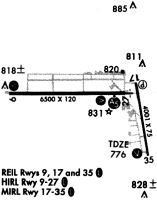
Runways
Runway Summary
| Runways: | 08/26 09/27 18/36 |
| Longest Runway: | 09/27 is 6500 ft (1981 m) long |
| Runways with an Instrument Approach: | 27 |
EKI Airport Runway Details
| Runway 08/26 | 2480 ft x 250 ft (756 m x 76 m) | |
| Runway Length Source: | 3RD PARTY SURVEY as of 10/26/2009 | |
| Surface: | Turf - Excellent condition - No special surface treatment | |
Runway 08 |
Runway 26 |
|
Elevation: |
769.3 | 773.3 |
Latitude: |
41-43-10.4962N | 41-43-10.7570N |
Longitude: |
086-00-51.3686W | 086-00-18.6714W |
|
Runway True Alignment: |
089 | 269 |
Glide Path Angle: |
0.0 degrees | 0.0 degrees |
Runway Markings Condition: |
Fair | Fair |
Object Centerline Offset: |
0 ft. left and right of centerline | |
Declared Distances |
||
Take Off Run Avbl. (TORA): |
2480 | 2480 |
Take Off Distance Avbl. (TODA): |
2480 | 2480 |
Actual Stop Dist. Avbl. (ASDA): |
2480 | 2480 |
Landing Dist. Avbl. (LDA): |
2480 | 2480 |
| Runway 09/27 | 6500 ft x 120 ft (1981 m x 37 m) | |
| Runway Length Source: | 3RD PARTY SURVEY as of 10/26/2009 | |
| Surface: | Turf - Excellent condition - Saw-cut or plastic grooved | |
| Runway Edge Lights: | High Intensity | |
Runway Weight Bearing Capacity (in thousands of pounds) |
||
| Single Wheel Landing Gear: | 40.0 | |
| Dual Wheel Landing Gear: | 60.0 | |
| Dual Tandem Wheel Landing Gear: | 120.0 | |
Runway 09 |
Runway 27 |
|
Elevation: |
770.4 | 777.1 |
Latitude: |
41-43-15.2447N | 41-43-15.3639N |
Longitude: |
086-01-09.7969W | 085-59-44.0886W |
|
Runway True Alignment: |
090 | 270 |
ILS Type: |
ILS | |
Glide Path Angle: |
3.0 degrees | 3.0 degrees |
Runway Markings Type: |
Precision Instrument | Precision Instrument |
Runway Markings Condition: |
Good | Good |
Object at End: |
TREES | TREES |
Object Height: |
40 | 69 |
Distance from End: |
1050 | 2645 |
Object Centerline Offset: |
0 ft. left and right of centerline | |
Visual Glide Slope Indicators: |
4-Box VASI On Left Side Of Runway | 4-Light PAPI On Left Side Of Runway |
Runway Visual Range (RVR): |
Rollout | Touchdown |
Approach Light System: |
1,400 Foot Medium Intensity Approach Lighting System With Runway Alignment Indicator Lights | |
REIL: |
Yes | |
Threshold Crossing Height: |
38 | 46 |
Declared Distances |
||
Take Off Run Avbl. (TORA): |
6500 | 6500 |
Take Off Distance Avbl. (TODA): |
6500 | 6500 |
Actual Stop Dist. Avbl. (ASDA): |
6500 | 6500 |
Landing Dist. Avbl. (LDA): |
6500 | 6500 |
| Runway 18/36 | 3999 ft x 75 ft (1219 m x 23 m) | |
| Runway Length Source: | 3RD PARTY SURVEY as of 10/26/2009 | |
| Surface: | Turf - Excellent condition - Saw-cut or plastic grooved | |
| Runway Edge Lights: | Medium Intensity | |
Runway Weight Bearing Capacity (in thousands of pounds) |
||
| Single Wheel Landing Gear: | 45.0 | |
| Dual Wheel Landing Gear: | 65.0 | |
Runway 18 |
Runway 36 |
|
Elevation: |
777.2 | 771.8 |
Latitude: |
41-43-20.0978N | 41-42-40.9870N |
Longitude: |
085-59-35.7976W | 085-59-28.4028W |
|
Runway True Alignment: |
172 | 352 |
Glide Path Angle: |
3.0 degrees | 4.0 degrees |
Traffic Pattern: |
Left | Left |
Runway Markings Type: |
Nonprecision Instrument | Nonprecision Instrument |
Runway Markings Condition: |
Poor | Poor |
Object at End: |
TREES | TREES |
Object Height: |
40 | 62 |
Distance from End: |
1200 | 1200 |
Object Centerline Offset: |
0 ft. left and right of centerline | |
Visual Glide Slope Indicators: |
4-Light PAPI On Left Side Of Runway | 4-Box VASI On Left Side Of Runway |
REIL: |
Yes | Yes |
Threshold Crossing Height: |
38 | 57 |
Declared Distances |
||
Take Off Run Avbl. (TORA): |
4001 | 4001 |
Take Off Distance Avbl. (TODA): |
4001 | 4001 |
Actual Stop Dist. Avbl. (ASDA): |
4001 | 4001 |
Landing Dist. Avbl. (LDA): |
4001 | 4001 |
Services
Fuel Available: |
100LL, Jet A |
Landing Fees: |
No |
Parking: |
Hangars and tiedowns available |
Maps & Diagrams
EKI Sectional
Flight Planning
at skyvector.com
at skyvector.com