Location
Latitude: |
36-14-01.4140N (36.233726) |
Longitude: |
101-25-55.8820W (-101.432189) |
Elevation: |
3205.3 feet MSL (977 m MSL) |
Magnetic Variation: |
5.5 E (as of April 2024 from WMM2020 model) |
Time Zone: |
UTC -6.0 (Standard Time) UTC -5.0 (Daylight Savings Time) |
From City: |
02 N.M. SW of Gruver, Texas |
Found On: |
Wichita Chart |
FAA Region: |
ASW |
Contacts
Manager: |
Publicly owned: |
| JOHNNIE WILLIAMS PO BOX 947 GRUVER, TX 79040 806-733-2424 |
CITY OF GRUVER PO BOX 947 GRUVER, TX 79040 806-733-2424 |
Operations
Airport Status: |
Operational |
Facility Use: |
Public |
Type: |
Airport |
Activation Date: |
12/1978 |
Control tower: |
No |
Attendance (Months/Days/Hours): |
Months/Days/Hours Unattended |
Boundary ARTCC: |
ZAB (Albuquerque) |
Responsible ARTCC: |
ZAB (Albuquerque) |
Lighting Schedule: |
SEE RMK |
Segmented Circle Indicator: |
Yes |
Traffic Pattern Altitude (MSL): |
4205 feet (1282 m) |
NOTAMs Facility: |
FTW |
NOTAM-D Service: |
Yes |
International Airport of Entry: |
No |
Customs Landing Rights: |
No |
Military Landing Rights: |
Yes |
Based Aircraft
| Single Engine: | 13 |
| Gliders: | 1 |
Annual Operations (as of 09/16/2021)
| Total Operations: | 3100 | |
| GA Local: | 3000 | 96.8% |
| GA Itinerant: | 100 | 3.2% |
Communications
| CTAF: | 122.900 |
- APCH/DEP SVC PRVDD BY ALBUQUERQUE ARTCC (ZAB) ON FREQS 127.85/285.475 (AMARILLO RCAG).
Fixed Based Operators (FBOs) & Fuel
(Click on a business for detail)
Please help us keep this information up to date. This is a FREE SERVICE just like everything else on Airport Guide! If you see that a business needs to be added, modified, or deleted please fill out our Update Form.
To add, modify, or delete a business click here.
Please help us keep this information up to date. This is a FREE SERVICE just like everything else on Airport Guide! If you see that a business needs to be added, modified, or deleted please fill out our Update Form.
Area Code: 806 |
| Business Name | Frequency | Phone | Fuel Grade |
|---|
Flight Service Stations
| Primary | Alternate | |
| FSS on Field: | N | |
| FSS Name (ID): | Fort Worth(FTW) | |
| Frequency: | ||
| Toll Free Phone: | 1-800-WX-BRIEF |
Instrument Procedures / Charts
FAA Terminal Procedures valid from 0901Z 03/21/24 to 0901Z 04/18/24.
There are various types of charts available for an airport. They are listed in the Page Type column. Here is a legend for those types:
APD - Airport Diagram
DP - Departure Procedure Charts
HOT - Hot Spots
IAP - Instrument Approach Procedure Charts
MIN - Minimums
STAR - Standard Terminal Arrival Charts
| Page Type | Page Name | Volume | Action Since Last Cycle |
|---|---|---|---|
| IAP | RNAV (GPS) RWY 02 | SC-2 | |
| IAP | RNAV (GPS) RWY 20 | SC-2 | |
| MIN | TAKEOFF MINIMUMS | SC-2 |
Terminal Procedures are only available for airports in several countries with more being added all the time. If you are looking for a specific country's charts, please send an email to support(at)airportguide.com stating the country name. This will be used to prioritize the implementation.
Navigation Aids (Navaids) near E19
| Dist (NM) | ID | Morse Code | Name | Type | Freq | True Hdg | Mag Hdg |
|---|---|---|---|---|---|---|---|
| 25.7 | BGD | _ . . . _ _ . _ . . | Borger | TACAN | 108.60 | 174 | 169 |
| 28.5 | GUY | _ _ . . . _ _ . _ _ | Guymon | NDB | 275 | 352 | 347 |
| 34.8 | PYX | . _ _ . _ . _ _ _ . . _ | Perryton | NDB | 266 | 71 | 66 |
| 43.0 | PPA | . _ _ . . _ _ . . _ | Pampa | NDB | 368 | 150 | 145 |
| 49.5 | LB | . _ . . _ . . . | Panck | NDB | 383 | 27 | 22 |
| 50.9 | EHA | . . . . . . _ | Elkhart | NDB | 377 | 334 | 328 |
| 53.5 | LBL | . _ . . _ . . . . _ . . | Liberal | TACAN | 112.30 | 24 | 19 |
| 54.6 | DHT | _ . . . . . . _ | Dalhart | VORTAC | 112.00 | 261 | 255 |
| 55.9 | HQG | . . . . _ _ . _ _ _ . | Hugoton | NDB | 365 | 2 | 357 |
| 61.3 | PNH | . _ _ . _ . . . . . | Panhandle | VORTAC | 116.60 | 192 | 186 |
| 67.7 | AM | . _ _ _ | Pande | NDB | 251 | 195 | 189 |
| 75.4 | MMB | _ _ _ _ _ . . . | Mitbee | VORTAC | 115.60 | 84 | 79 |
| 81.9 | ULS | . . _ . _ . . . . . | Ulysses | NDB | 395 | 2 | 357 |
| 83.9 | CAO | _ . _ . . _ _ _ _ | Clayton | NDB | 332 | 279 | 273 |
| 85.4 | JHN | . _ _ _ . . . . _ . | Bear Creek | NDB | 341 | 350 | 344 |
| 93.4 | HRX | . . . . . _ . _ . . _ | Hereford | NDB | 341 | 208 | 202 |
| 95.2 | BFK | _ . . . . . _ . _ . _ | Buffalo | NDB | 215 | 66 | 61 |
Nearby Airports with Fuel
Notices to Airmen (NOTAMS)
Remarks
| A110*G | THIS AIRPORT HAS BEEN SURVEYED BY THE NATIONAL GEODETIC SURVEY. |
| A110-1 | FOR CD CTC ALBUQUERQUE ARTCC AT 505-856-4861. |
| A14 | CITY MANAGER. |
| A33-02/20 | EXTSV PAVEMENT CRACKING, POTHOLES AT RWY 20 THR. |
| A58-02 | 4 FT FENCE AT THR, 200 FT LEFT. |
| A81-APT | ACTVT MIRL RWY 02/20 - CTAF. |
Runways
Runway Summary
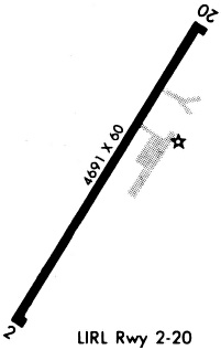
| Runways: | 02/20 |
| Longest Runway: | 02/20 is 4698 ft (1432 m) long |
| Runways with an Instrument Approach: |
E19 Airport Runway Details
| Runway 02/20 | 4698 ft x 60 ft (1432 m x 18 m) | |
| Runway Length Source: | NGS as of 03/19/1997 | |
| Surface: | Asphalt - Poor condition - No special surface treatment | |
| Runway Edge Lights: | Medium Intensity | |
Runway Weight Bearing Capacity (in thousands of pounds) |
||
| Single Wheel Landing Gear: | 12.5 | |
Runway 02 |
Runway 20 |
|
Elevation: |
3205.3 | 3186.8 |
Latitude: |
36-13-41.3540N | 36-14-21.4220N |
Longitude: |
101-26-10.4000W | 101-25-41.3860W |
|
Runway True Alignment: |
030 | 210 |
Glide Path Angle: |
0.0 degrees | 0.0 degrees |
Traffic Pattern: |
Left | Left |
Runway Markings Type: |
Nonprecision Instrument | Nonprecision Instrument |
Runway Markings Condition: |
Fair | Fair |
Object at End: |
FENCE | FENCE |
Object Height: |
4 | 4 |
Distance from End: |
200 | 370 |
Object Centerline Offset: |
197 ft. left of centerline | 140 ft. right of centerline |
Services
Airframe Repair: |
Major |
Powerplant Repair: |
Major |
Bottled Oxygen: |
None |
Bulk Oxygen: |
None |
Fuel Available: |
100LL, Jet A |
Landing Fees: |
No |
Parking: |
Hangars and tiedowns available |
Maps & Diagrams
E19 Sectional
Flight Planning
at skyvector.com
at skyvector.com